File:The Great Bahama Bank (Copernicus).jpg

Original file (4,363 × 2,540 pixels, file size: 2.58 MB, MIME type: image/jpeg)
Captions
Captions
Summary
[edit].jpg&action=edit§ion=1)
| Description |
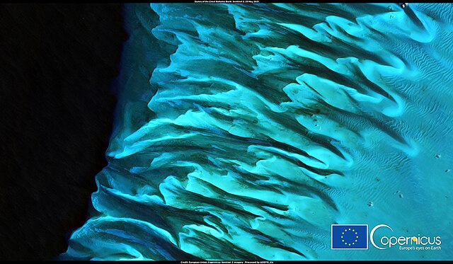
English: This image, acquired by one of the Copernicus Sentinel-2 satellites on 29 May 2021, shows the underwater dunes of the Great Bahama Bank in the Atlantic Ocean. The Great Bahama Bank is a large shallow water body located between Great Exuma and Andros islands in the Bahama Archipelago. The sea in this stretch of water has depths of no more than 5 metres. The limited depth of the seabed favours the growth of corals that cover much of the Bank. The marine area also has a considerable ecological value as it supports a complex food chain, as phytoplankton and some valuable species of tuna proliferate in the growing seasons. In 2016, the Bahamas government started a process to protect at least 20% of its marine environment, including the Great Bahama Bank. Built essentially as a land monitoring mission, the Copernicus Sentinel-2 satellites are now found to be very useful for a multitude of marine applications such as monitoring coastal waters and coral reefs, bathymetry, detecting marine debris etc. |
| Date | Taken on 29 May 2021 |
| Source | The Great Bahama Bank |
| Author | European Union, Copernicus Sentinel-2 imagery |
Licensing
[edit].jpg&action=edit§ion=2)

|
This image contains data from a satellite in the Copernicus Programme, such as Sentinel-1, Sentinel-2 or Sentinel-3. Attribution is required when using this image.
Attribution: Contains modified Copernicus Sentinel data 2021
The use of Copernicus Sentinel Data is regulated under EU law (Commission Delegated Regulation (EU) No 1159/2013 and Regulation (EU) No 377/2014). Relevant excerpts:
Free access shall be given to GMES dedicated data [...] made available through GMES dissemination platforms [...].
Access to GMES dedicated data [...] shall be given for the purpose of the following use in so far as it is lawful:
GMES dedicated data [...] may be used worldwide without limitations in time.
GMES dedicated data and GMES service information are provided to users without any express or implied warranty, including as regards quality and suitability for any purpose. |
File history
Click on a date/time to view the file as it appeared at that time.
| Date/Time | Thumbnail | Dimensions | User | Comment | |
|---|---|---|---|---|---|
| current | 19:33, 8 September 2023 | | 4,363 × 2,540 (2.58 MB) | OptimusPrimeBot (talk | contribs) | #Spacemedia - Upload of https://www.copernicus.eu/system/files/2021-06/image_day/20210602_GreatBahamaBank.jpg via Commons:Spacemedia |
You cannot overwrite this file.
File usage on Commons
There are no pages that use this file.
.jpg&oldid=799722655)