File:The Grand Theater of the War in Italy WDL413.png
Jump to navigation
Jump to search

Size of this preview: 723 × 600 pixels. Other resolutions: 289 × 240 pixels | 579 × 480 pixels | 926 × 768 pixels | 1,234 × 1,024 pixels.
Original file (1,234 × 1,024 pixels, file size: 2.87 MB, MIME type: image/png)
Captions
Captions
Add a one-line explanation of what this file represents
Summary[edit]
| Author |
Русский: Мортье, Пьер (1663-1736)
Français : Mortier, Pierre (1663-1736)
English: Mortier, Pierre (1663-1736)
中文:莫迪埃, 皮埃尔 (1663-1736)
Português: Mortier, Pierre (1663-1736)
العربية: مورتيير, بيير (1663-1736)
Español: Mortier, Pierre (1663-1736) |
| Title |
Русский: Большой театр военных действий в Италии
Français : Le grand théâtre de la guerre en Italie
English: The Grand Theater of the War in Italy
中文:意大利大战场
Português: O Grande Palco da Guerra na Itália
العربية: مسرح الأحداث الكبير للحرب في إيطاليا
Español: El Gran teatro de la guerra en Italia |
| Description |
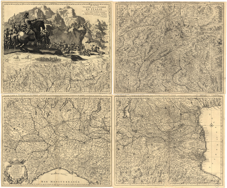
Русский: Пьер Мортье (1661-1711) был голландским издателем атласов, карт и схем. Мортье был внуком религиозных беженцев, покинувших Францию и поселившихся в Лейдене около 1625 года. Он вырос в Амстердаме, который в то время был центром международной книжной торговли. В юношеском возрасте он провел несколько лет в Париже, где познакомился с французскими картами и издателями. Вернувшись в Амстердам около 1685 года, он зарекомендовал себя как издатель карт высокого качества, в том числе репринтов работ Алексиса-Юбера Жайо, Николаса Сансона и других великих французских картографов. Эту карту подчеркнуто военной направленности Мортье составил для принца Евгения Савойского (1663-1736), главнокомандующего войсками Священной Римской империи в войне за испанское наследство (1701-14). Эта война была соперничеством за европейское влияние, в результате которого Франция Людовика XIV оказалась натравленной на коалицию, включавшую Англию, Голландию и Священную Римскую империю. Первые этапы войны развернулись в северной Италии. В работу Мортье включены четыре карты, на которых изображены разные зоны конфликта. В верхнем левом углу карты размещены яркие гравюры Евгения, разворачивающего военные операции в Альпах, а также гравюра пленения маршала Франсуа де Нефвиль де Виллерой в ночь с 31 января на 1 февраля 1702 года. Карта в правом верхнем углу доходит до Германии (Баварии) и Австрии.
Священная Римская империя; Военные карты; Война за испанское наследство, 1701-1714 гг. Français : Pierre Mortier (1661-1711) était un éditeur néerlandais d'atlas ainsi que de cartes terrestres et marines. Petit-fils de réfugiés religieux de France qui se sont installés à Leiden aux environs de 1625, Mortier grandit à Amsterdam, qui était à l'époque le centre du commerce international de l'édition. En tant que jeune homme, il passa plusieurs années à Paris, où il découvrit les cartes et les éditeurs français. De retour à Amsterdam vers 1685, il s'établit comme éditeur de cartes de haute qualité, comprenant des rééditions des œuvres d'Alexis-Hubert Jaillot, de Nicolas Sanson, et d'autres grands cartographes français. Mortier a produit ce plan d'attaque militaire pour le Prince Eugène de Savoie (1663-1736), principal commandant des forces du Saint Empire romain germanique dans la guerre de Succession d'Espagne (1701-14). La guerre était une lutte pour la dominance de l'Europe, elle oposait la France de Louis XIV contre une coalition comprenant l'Angleterre, la Hollande et le Saint Empire Romain germanique. Une grande partie des premiers combats ont eu lieu au nord de l'Italie. L'oeuvre de Mortier comprend quatre cartes indiquant les différentes zones de conflit. La carte en haut à gauche contient des gravures picturales d'Eugène conduisant des opérations militaires dans les Alpes et la capture du Maréchal François de Neufville de Villeroy, dans la nuit du 31 Janvier 1702 au 1er Février 1702. La carte en haut à droite s'étend à l'Allemagne (Bavière) et à l'Autriche.
Saint Empire romain; Cartes militaires; Succession d'Espagne, Guerre de, 1701-1714 English: Pierre Mortier (1661-1711) was a Dutch publisher of atlases, maps, and charts. The grandson of religious refugees from France who settled in Leiden about 1625, Mortier grew up in Amsterdam, which at the time was the center of the international book trade. As a young man, he spent several years in Paris, where he got to know French maps and publishers. Returning to Amsterdam about 1685, he established himself as a publisher of high quality maps, including reprints of works by Alexis-Hubert Jaillot, Nicolas Sanson, and the other great French mapmakers. Mortier produced this striking military map for Prince Eugene of Savoy (1663-1736), the principal commander of the forces of the Holy Roman Empire in the War of the Spanish Succession (1701-14). The war was a contest for European dominance that pitted the France of Louis XIV against a coalition that included England, Holland, and the Holy Roman Empire. Much of the early fighting took place in northern Italy. Mortier’s work includes four maps showing different areas of conflict. The map at the upper left contains vivid engravings of Eugene conducting military operations in the Alps and of his capture of Marshall François de Neufville de Villeroy on the night of January 31-February 1, 1702. The map at the upper right extends into Germany (Bavaria) and Austria.
Holy Roman Empire; Military maps; Spanish Succession, War of, 1701-1714 中文:皮埃尔·莫蒂埃(1661-1711 年)是一位荷兰地图册、地图与图表出版商。 作为 1625 年左右定居莱顿的法国宗教难民的子孙,莫蒂埃在阿姆斯特丹成长,当时阿姆斯特丹是国际图书交易中心。 年轻时,他曾在巴黎呆过一段时间,在那里他开始结识法国地图出版商。 1685 年返回阿姆斯特丹后,他自己也成立了一家高品质的出版公司,包括翻印亚历克斯·休伯特·简洛特、尼古拉斯·桑松以及其他伟大的法国制图师作品。 莫蒂埃为萨沃王朝的尤金王子(1663-1736 年)创作了这一惊世骇俗的军事地图,尤金王子是神圣罗马帝国在西班牙王位继承战争(1701-1714 年)中的主要指挥官。 这场战争是以法国路易十四为代表的欧洲联盟对抗包括英国、荷兰以及神圣罗马帝国的联盟。 早期大部分战事均发生在意大利北部。 莫蒂埃的著作包括四幅显示不同战役地点的地图。 左上角的地图栩栩如生地描述了尤金在阿尔卑斯山进行的军事帷幄,并在 1702 年 1 月 31 日至 2 月 1 日夜间抓获了马歇尔·弗朗索瓦(Marshall François de Neufville de Villeroy)。 本地图右上角延伸至德国(巴伐利亚)与奥地利。
神圣罗马帝国; 军事地图; 西班牙王位继承战争,1701-1714 年 Português: Pierre Mortier (1661-1711) foi um editor holandês de atlas, mapas e gráficos. Neto de refugiados religiosos franceses que se estabeleceram em Leiden por volta de 1625, Mortier cresceu em Amsterdam que, na época, era o centro do comércio internacional livreiro. Quando jovem, ele viveu vários anos em Paris, onde passou a conhecer os mapas e os editores franceses. De volta à Amsterdam, por volta de 1685, ele se estabeleceu como editor de mapas de alta qualidade, incluindo reedições das obras de Alexis-Hubert Jaillot, Nicolas Sanson e de outros grandes cartógrafos franceses. Mortier produziu este impressionante mapa militar para o Principe Eugene de Sabóia (1663-1736), o principal comandante das forças do Sagrado Império Romano na Guerra da Sucessão Espanhola (1701-14). A guerra foi uma disputa pelo domínio europeu que lançou a França de Luís XVI contra uma coalizão que incluia a Inglaterra, Holanda e o Sagrado Império Romano. Grande parte dos combates iniciais aconteceu no norte da Itália. A obra de Mortier inclui quatro mapas mostrando as diferentes áreas do conflito. O mapa no canto superior à esquerda contém gravuras vívidas de Eugene à frente das operações militares nos Alpes e sua captura do marechal François de Neufville de Villeroy na noite de 31 de janeiro- 1 de fevereiro de 1702. O mapa no canto superior à direita se extende pela a Alemanha (Bavária) e a Áustria.
Sacro Império Romano; Mapas militares; Sucessão Espanhola, Guerra da, 1701-1714 العربية: كان بيير مورتيير ( 1661- 1711) ناشر أطالس وخرائط ورسوم بيانية هولنديا. وهو حفيد لاجئين متدينين من فرنسا استقروا حول ليدن عام 1625 وترعرع في أمستردام التي كانت في ذلك الوقت مركزا للتجارة الدولية للكتب. قضى عدة سنوات في باريس عندما كان شابًا حيث تعرف على الخرائط الفرنسية والناشرين. عاد إلى أمستردام حوالي عام 1865 حيث وطَّد نفسه كناشر خرائط ذات جودة عالية، بما فيها إعادة طبع أعمال ألكسيس - هيوبرت جيلوت ونيكولا سانسون ومعدي الخرائط الفرنسيين الآخرين. أنتج مورتيير هذه الخريطة العسكرية اللافتة للنظر للأمير يوجين سافوي (1663- 1736)، وهوالقائد الرئيسي لقوات الإمبراطورية الرومانية المقدسة في حرب الوراثة الإسبانية (1701- 14). كانت الحرب سباقا لبسط الهيمنة الأوروبية وضعت فرنسا وملكها لويس الرابع عشر ضد تحالف ضم إنكلترا وهولندا والإمبراطورية الرومانية المقدسة. دار الكثير من القتال المبكر في شمال إيطاليا. تضمنت أعمال مورتيير أربعة خرائط تبين مناطق مختلفة من الصراع. تتضمن الخريطة في أعلى اليسار نقوشات مفعمة بالحيوية ليوجين أثناء قيامه بعمليات عسكرية في جبال الألب واعتقاله مارشال فرانسوا دي فيليروا ليلة 31 كانون الثاني - 1 شباط 1702. تمتد الخريطة في اليمين الأعلى إلى ألمانيا (بافاريا) والنمسا.
الإمبراطورية الرومانية المقدسة; الخرائط الحربية; الوراثة الإسبانية، حرب 1701-1714 Español: Pierre Mortier (1661-1711) fue un editor holandés de atlas, mapas y cartas de navegación. Nieto de refugiados religiosos franceses asentados en Leiden alrededor de 1625, Mortier creció en Amsterdam, que en aquel momento era el centro internacional del comercio de libros. Durante su juventud, pasó varios años en París, donde se familiarizó con los mapas y editores franceses. Regresó a Amsterdam alrededor de 1685 y se estableció como editor de mapas de alta calidad, incluyendo reediciones de obras de Alexis-Hubert Jaillot, Nicolas Sanson y otros grandes cartógrafos franceses. Mortier creó este impresionante mapa militar para el príncipe Eugenio de Saboya (1663-1736), comandante principal de las fuerzas del Sacro Imperio Romano durante la Guerra de Sucesión española (1701-14). La guerra fue una contienda por la dominación europea que enfrentó a Luis XIV de Francia contra una coalición que incluía a Inglaterra, Holanda y el Sacro Imperio Romano. La mayor parte de los primeros combates tuvo lugar al norte de Italia. La obra de Mortier incluye cuatro mapas que muestran diferentes zonas de conflicto. El mapa de la parte superior izquierda contiene grabados realistas de Eugenio llevando a cabo operaciones militares en los Alpes, y de su captura del mariscal François de Neufville de Villeroy la noche del 31 de enero al 1 de febrero de 1702. El mapa de la parte superior derecha se extiende hasta Alemania (Baviera) y Austria.
Sacro Imperio Romano; Mapas militares; Sucesión española, Guerra de, 1701-1714 |
| Date | 1705 |
| Medium |
Русский: Карты
Français : Cartes
English: Maps
中文:地图
Português: Mapas
العربية: خرائط
Español: Mapas |
| Dimensions |
English: 1 map on 4 sheets : 49 x 59 centimeters or smaller |
| Collection |
Русский: Библиотека Конгресса
Français : Bibliothèque du Congrès
English: Library of Congress
中文:国会图书馆
Português: Biblioteca do Congresso
العربية: مكتبة الكونغرس
Español: Biblioteca del Congreso |
| Place of creation |
Русский: Австрия
Français : Autriche
English: Austria
中文:奥地利
Português: Áustria
العربية: النمسا
Español: Austria |
| Notes |
Original language title: Le Grand Teatre de la Guerre en Italie Русский: Приблизительный масштаб: 1:420 000
Français : Échelle approximative 1 : 420 000
English: Scale approximately 1:420,000
中文:比例尺约为 1:420,000
Português: Escala aproximadamente 1:420.000
العربية: المقياس نحو 1:420،000
Español: Escala aproximada 1:420.000 |
| References | http://hdl.loc.gov/loc.wdl/dlc.413 |
| Source/Photographer |
|
Licensing[edit]
|
This is a faithful photographic reproduction of a two-dimensional, public domain work of art. The work of art itself is in the public domain for the following reason:
The official position taken by the Wikimedia Foundation is that "faithful reproductions of two-dimensional public domain works of art are public domain".
This photographic reproduction is therefore also considered to be in the public domain in the United States. In other jurisdictions, re-use of this content may be restricted; see Reuse of PD-Art photographs for details. | ||||
File history
Click on a date/time to view the file as it appeared at that time.
| Date/Time | Thumbnail | Dimensions | User | Comment | |
|---|---|---|---|---|---|
| current | 16:23, 11 March 2014 | | 1,234 × 1,024 (2.87 MB) | Fæ (talk | contribs) | =={{int:filedesc}}== {{Artwork |artist = |author ={{ru|1=Мортье, Пьер (1663-1736)}} {{fr|1=Mortier, Pierre (1663-1736)}} {{en|1=Mortier, Pierre (1663-1736)}} {{zh|1=莫迪埃, 皮埃尔 (1663-1736)}} {{pt|1=Mortier, Pierre (1663-1736)}} {{ar|... |
You cannot overwrite this file.
File usage on Commons
The following page uses this file: