File:The Cumbrian and Durham Derwents.svg
Jump to navigation
Jump to search

Size of this PNG preview of this SVG file: 800 × 395 pixels. Other resolutions: 320 × 158 pixels | 640 × 316 pixels | 1,024 × 505 pixels | 1,280 × 631 pixels | 2,560 × 1,262 pixels | 1,821 × 898 pixels.
Original file (SVG file, nominally 1,821 × 898 pixels, file size: 8 MB)
Captions
Captions
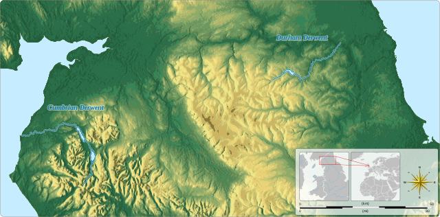
The Locations of the Cumbrian and Durham Derwents
Summary[edit]
| Description |
English: The Location of the rivers named Derwent which scholars consider to be the most plausible identities of the Derwennyd referred to in the poem Dinogad's smock.
|
||||||||||||||||||||||||||||||||||||||||||||||||||||||||
| Date | |||||||||||||||||||||||||||||||||||||||||||||||||||||||||
| Source |
Own work Derived from; Information from:
|
||||||||||||||||||||||||||||||||||||||||||||||||||||||||
| Author | Goran_tek-en | ||||||||||||||||||||||||||||||||||||||||||||||||||||||||
| Permission (Reusing this file) |
This file is licensed under the Creative Commons Attribution-Share Alike 4.0 International license. Attribution: Goran tek-en
|
||||||||||||||||||||||||||||||||||||||||||||||||||||||||
| SVG development | This vector image was created with Inkscape. |
||||||||||||||||||||||||||||||||||||||||||||||||||||||||


| Object location | | View this and other nearby images on: OpenStreetMap |
|---|


File history
Click on a date/time to view the file as it appeared at that time.
| Date/Time | Thumbnail | Dimensions | User | Comment | |
|---|---|---|---|---|---|
| current | 10:53, 9 November 2021 | | 1,821 × 898 (8 MB) | Goran tek-en (talk | contribs) | {{Information |description ={{en|The Location of the rivers named Derwent which scholars consider to be the most plausible identities of the ''Derwennyd'' referred to in the poem ''Dinogad's smock''.}} {{Institution |wikidata=Q1200401}} {{Institution |wikidata=Q2457755}} {{Institution |wikidata=Q934551}} {{Institution |wikidata=Q506996}} {{Institution |wikidata=Q1345964}} |date =2021-11-09 |source ={{Own}}<br> {{Derived from|United_Kingdom_adm_location_map.svg|Map... |
You cannot overwrite this file.
File usage on Commons
The following page uses this file:
File usage on other wikis
The following other wikis use this file:
- Usage on en.wikipedia.org