File:The Amazing Race Canada 4 map.png
Jump to navigation
Jump to search

Size of this preview: 619 × 600 pixels. Other resolutions: 248 × 240 pixels | 495 × 480 pixels | 1,000 × 969 pixels.
Original file (1,000 × 969 pixels, file size: 74 KB, MIME type: image/png)
Captions
Captions
Add a one-line explanation of what this file represents
Summary[edit]
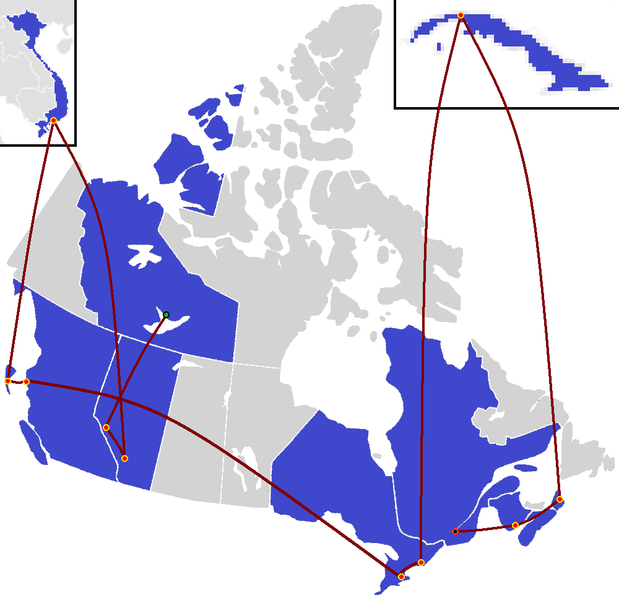
| Description | The route map of The Amazing Race Canada 4 |
| Date | (UTC) |
| Source | Canada blank map.svg |
| Author |
ApprenticeFan work
|
Licensing[edit]
| I, the copyright holder of this work, release this work into the public domain. This applies worldwide. In some countries this may not be legally possible; if so: I grant anyone the right to use this work for any purpose, without any conditions, unless such conditions are required by law. |
File history
Click on a date/time to view the file as it appeared at that time.
| Date/Time | Thumbnail | Dimensions | User | Comment | |
|---|---|---|---|---|---|
| current | 01:10, 21 August 2021 | | 1,000 × 969 (74 KB) | Shadow2 (talk | contribs) | James Bay belongs to Nunavut |
| 07:25, 14 September 2016 |  | 1,000 × 969 (71 KB) | ApprenticeFan (talk | contribs) | Montreal | |
| 23:52, 6 September 2016 |  | 1,000 × 969 (71 KB) | ApprenticeFan (talk | contribs) | New Brunswick for early | |
| 08:36, 31 August 2016 |  | 1,000 × 969 (71 KB) | ApprenticeFan (talk | contribs) | Nova Scotia | |
| 08:30, 24 August 2016 |  | 1,000 × 969 (68 KB) | ApprenticeFan (talk | contribs) | Cuba | |
| 04:02, 10 August 2016 |  | 1,000 × 969 (72 KB) | Sportsfan 1234 (talk | contribs) | Reverted to version as of 04:00, 10 August 2016 (UTC) | |
| 04:02, 10 August 2016 |  | 1,000 × 969 (72 KB) | Sportsfan 1234 (talk | contribs) | leg 7 | |
| 04:00, 10 August 2016 |  | 1,000 × 969 (72 KB) | Sportsfan 1234 (talk | contribs) | Updated to include up to leg 7 | |
| 10:52, 27 July 2016 |  | 1,000 × 969 (58 KB) | ApprenticeFan (talk | contribs) | British Columbia | |
| 15:10, 13 July 2016 |  | 1,000 × 969 (56 KB) | ApprenticeFan (talk | contribs) | Vietnam |
You cannot overwrite this file.
File usage on Commons
The following 9 pages use this file:
- User:Chumwa/OgreBot/Travel and communication maps/2016 August 1-10
- User:Chumwa/OgreBot/Travel and communication maps/2016 August 21-31
- User:Chumwa/OgreBot/Travel and communication maps/2016 July 1-10
- User:Chumwa/OgreBot/Travel and communication maps/2016 July 11-20
- User:Chumwa/OgreBot/Travel and communication maps/2016 July 21-31
- User:Chumwa/OgreBot/Travel and communication maps/2016 June 21-30
- User:Chumwa/OgreBot/Travel and communication maps/2016 September 1-10
- User:Chumwa/OgreBot/Travel and communication maps/2016 September 11-20
- User:Chumwa/OgreBot/Travel and communication maps/2021 August 21-31
File usage on other wikis
The following other wikis use this file:
- Usage on en.wikipedia.org
- Usage on no.wikipedia.org
- Usage on zh.wikipedia.org