File:Thayet-District-Burma-2010.png
Jump to navigation
Jump to search

Size of this preview: 800 × 541 pixels. Other resolutions: 320 × 216 pixels | 640 × 433 pixels | 1,024 × 693 pixels | 1,313 × 888 pixels.
Original file (1,313 × 888 pixels, file size: 210 KB, MIME type: image/png)
Captions
Captions
Add a one-line explanation of what this file represents

|
This locator map image could be re-created using vector graphics as an SVG file. This has several advantages; see Commons:Media for cleanup for more information. If an SVG form of this image is available, please upload it and afterwards replace this template with
{{vector version available|new image name}}.
It is recommended to name the SVG file “Thayet-District-Burma-2010.svg”—then the template Vector version available (or Vva) does not need the new image name parameter. |
Summary
[edit]
| Description |
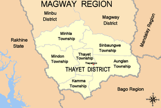
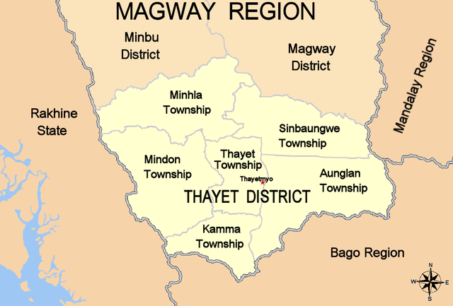
English: Map of Thayet District of Mayway (Magwe) Region, Burma (Mynamar), showing internal townships, capital Thayetmyo, adjacent districts and regions/states, based upon data from Myanmar Information Management Unit (MIMU) for Magway Division. |
| Date | |
| Source | Own work |
| Author | Bejnar |
| Permission (Reusing this file) |
Public domain dedication |
Licensing
[edit]
I, the copyright holder of this work, hereby publish it under the following license:
| This file is made available under the Creative Commons CC0 1.0 Universal Public Domain Dedication. | |
| The person who associated a work with this deed has dedicated the work to the public domain by waiving all of their rights to the work worldwide under copyright law, including all related and neighboring rights, to the extent allowed by law. You can copy, modify, distribute and perform the work, even for commercial purposes, all without asking permission.
|
File history
Click on a date/time to view the file as it appeared at that time.
| Date/Time | Thumbnail | Dimensions | User | Comment | |
|---|---|---|---|---|---|
| current | 21:17, 10 November 2010 | | 1,313 × 888 (210 KB) | Bejnar (talk | contribs) | Reverted to version as of 21:14, 10 November 2010 |
| 21:16, 10 November 2010 |  | 1,313 × 888 (210 KB) | Bejnar (talk | contribs) | add missing township, Minhla Township | |
| 21:14, 10 November 2010 |  | 1,313 × 888 (210 KB) | Bejnar (talk | contribs) | add missing township, Minhla Township | |
| 21:04, 8 November 2010 |  | 1,313 × 888 (197 KB) | Bejnar (talk | contribs) | {{Information |Description={{en|1=Map of Thayet District of Mayway (Magwe) Region, Burma (Mynamar), showing internal townships, capital Thayetmyo, adjacent districts and regions/states, based upon data from Myanmar Information Management Unit (MIMU) for M |
You cannot overwrite this file.
File usage on Commons
There are no pages that use this file.
File usage on other wikis
The following other wikis use this file:
- Usage on ca.wikipedia.org
- Usage on en.wikipedia.org
- Usage on www.wikidata.org
- Usage on zh.wikipedia.org