File:Thameslink.svg
Jump to navigation
Jump to search

Size of this PNG preview of this SVG file: 688 × 600 pixels. Other resolutions: 275 × 240 pixels | 551 × 480 pixels | 881 × 768 pixels | 1,175 × 1,024 pixels | 2,350 × 2,048 pixels | 1,807 × 1,575 pixels.
Original file (SVG file, nominally 1,807 × 1,575 pixels, file size: 1.45 MB)
Captions
Captions
Add a one-line explanation of what this file represents
Summary
[edit]
| Description |
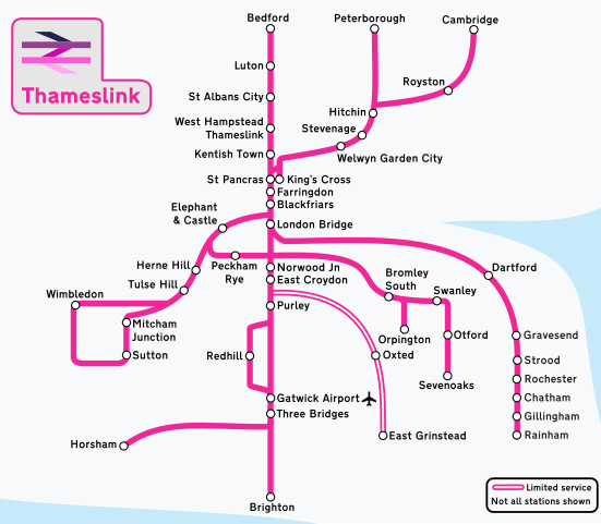
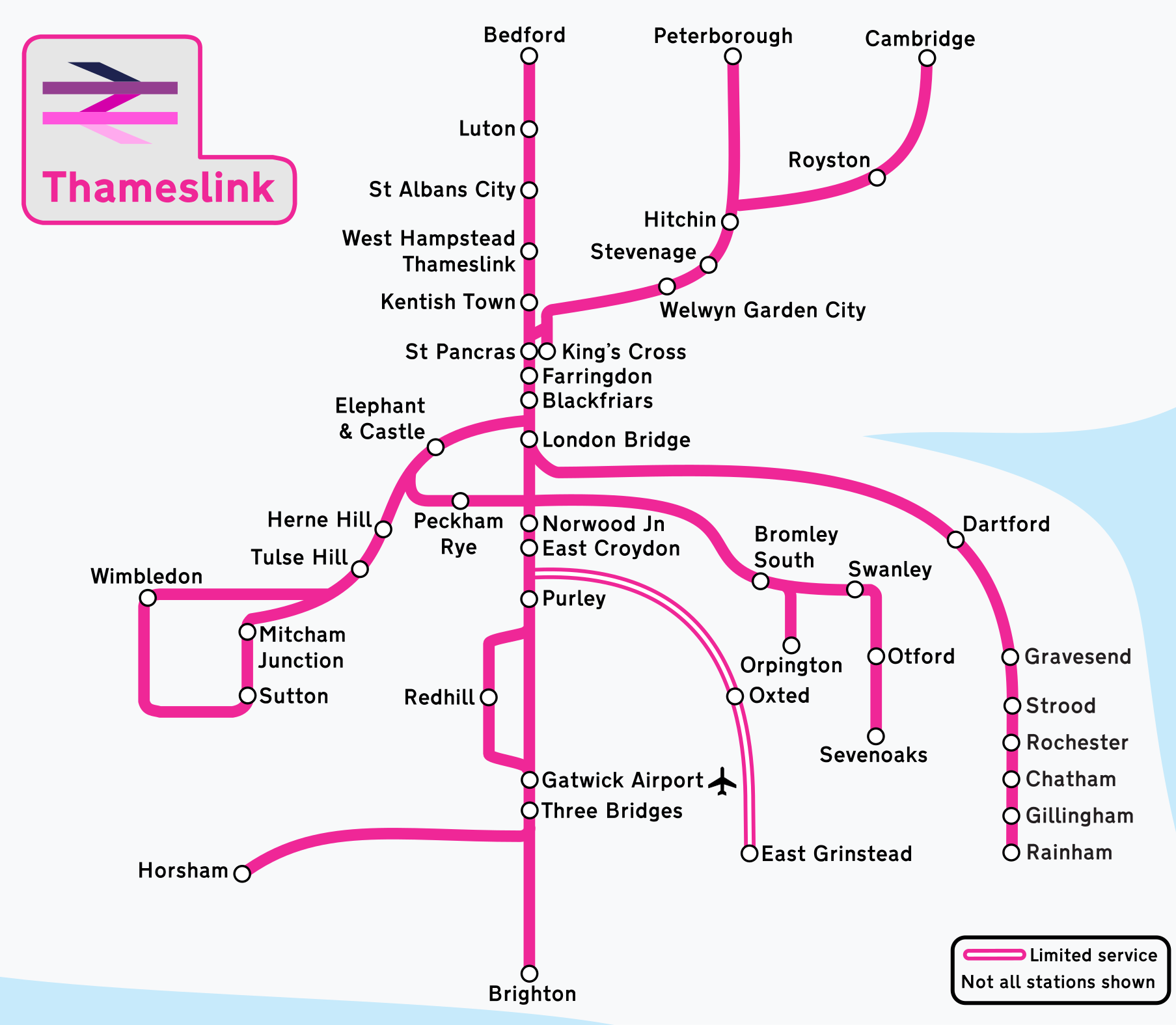
English: A vector map of the Thameslink network. |
| Date | |
| Source | Own work |
| Author | Rcsprinter123 |
Licensing
[edit]
I, the copyright holder of this work, hereby publish it under the following license:
This file is licensed under the Creative Commons Attribution 3.0 Unported license.
- You are free:
- to share – to copy, distribute and transmit the work
- to remix – to adapt the work
- Under the following conditions:
- attribution – You must give appropriate credit, provide a link to the license, and indicate if changes were made. You may do so in any reasonable manner, but not in any way that suggests the licensor endorses you or your use.
File history
Click on a date/time to view the file as it appeared at that time.
| Date/Time | Thumbnail | Dimensions | User | Comment | |
|---|---|---|---|---|---|
| current | 21:17, 30 May 2023 | | 1,807 × 1,575 (1.45 MB) | Rcsprinter123 (talk | contribs) | rm Littlehampton route following service change |
| 02:54, 28 September 2021 |  | 1,807 × 1,575 (4.11 MB) | Rcsprinter123 (talk | contribs) | . | |
| 00:41, 9 July 2021 |  | 1,807 × 1,575 (4.11 MB) | Rcsprinter123 (talk | contribs) | . | |
| 02:19, 6 July 2021 |  | 1,807 × 1,575 (1.47 MB) | Rcsprinter123 (talk | contribs) | Uploaded own work with UploadWizard |
You cannot overwrite this file.
File usage on Commons
The following 10 pages use this file:
- User:Chumwa/OgreBot/Public transport information/2021 July 1-10
- User:Chumwa/OgreBot/Public transport information/2021 September 21-30
- User:Chumwa/OgreBot/Public transport information/2023 May 21-31
- User:Chumwa/OgreBot/Transport Maps/2021 July 1-10
- User:Chumwa/OgreBot/Transport Maps/2021 September 21-30
- User:Chumwa/OgreBot/Transport Maps/2023 May 21-31
- User:Mattbuck/Railways/2021 July
- User:Mattbuck/Railways/2021 September/Overflow 1
- User:Mattbuck/Railways/2023 May
- Category:Thameslink
File usage on other wikis
The following other wikis use this file:
- Usage on da.wikipedia.org
- Usage on en.wikipedia.org
- Usage on en.wikivoyage.org
- Usage on es.wikipedia.org
- Usage on it.wikipedia.org
- Usage on uk.wikipedia.org
- Usage on www.wikidata.org