File:Test PSK826Th CoG uT.svg
Jump to navigation
Jump to search

Size of this PNG preview of this SVG file: 778 × 599 pixels. Other resolutions: 312 × 240 pixels | 623 × 480 pixels | 997 × 768 pixels | 1,280 × 986 pixels | 2,560 × 1,972 pixels | 853 × 657 pixels.
Original file (SVG file, nominally 853 × 657 pixels, file size: 1.04 MB)
Captions
Captions
Add a one-line explanation of what this file represents
Summary
[edit]
| Description |
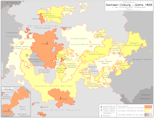
Deutsch: Übersichtskarte (S-C u G im Deutschen Bund 1826) Karte der Mitgliedstaaten des Deutschen Bundes 1826. Lage und Staatsgebiet von Sachsen-Coburg und Gotha ist rot gekennzeichnet, die übrigen thüringischen Staaten erscheinen in gelber Farbe. |
| Source | IEG-Maps am Institut für Europäische Geschichte Mainz, p826DB_CoG |
| Author | Andreas Kunz, J. Robert Moeschl |
Deutsch: Kartenserver IEG-Maps am Institut für Europäische Geschichte Mainz (http://www.ieg-maps.uni-mainz.de).
English: Server IEG-Maps; Institute of European History Mainz, Germany (http://www.ieg-maps.uni-mainz.de).
This tag does not indicate the copyright status of the attached work. A normal copyright tag is still required. See Commons:Licensing for more information. |
Licensing
[edit]
I, the copyright holder of this work, hereby publish it under the following license:
This file is licensed under the Creative Commons Attribution-Share Alike 3.0 Germany license.
- You are free:
- to share – to copy, distribute and transmit the work
- to remix – to adapt the work
- Under the following conditions:
- attribution – You must give appropriate credit, provide a link to the license, and indicate if changes were made. You may do so in any reasonable manner, but not in any way that suggests the licensor endorses you or your use.
- share alike – If you remix, transform, or build upon the material, you must distribute your contributions under the same or compatible license as the original.

File history
Click on a date/time to view the file as it appeared at that time.
| Date/Time | Thumbnail | Dimensions | User | Comment | |
|---|---|---|---|---|---|
| current | 14:18, 19 June 2009 | | 853 × 657 (1.04 MB) | Alexrk2 (talk | contribs) | == Beschreibung == {{Information |Description= {{de| Übersichtskarte (S-C u G im Deutschen Bund 1826)<br> Karte der Mitgliedstaaten des Deutschen Bundes 1826. Lage und Staatsgebiet von Sachsen-Coburg und Gotha ist rot gekennzeichnet, die übrigen thürin |
You cannot overwrite this file.
File usage on Commons
There are no pages that use this file.
File usage on other wikis
The following other wikis use this file:
- Usage on de.wikipedia.org