File:Terre Magellanique (Patagonia) in Carte du Paraguay, du Chili, du Detroit de Magellan.jpg
Jump to navigation
Jump to search
Size of this preview: 436 × 600 pixels. Other resolutions: 174 × 240 pixels | 349 × 480 pixels | 687 × 945 pixels.
Original file (687 × 945 pixels, file size: 895 KB, MIME type: image/jpeg)
Captions
Captions
Add a one-line explanation of what this file represents
| Description |
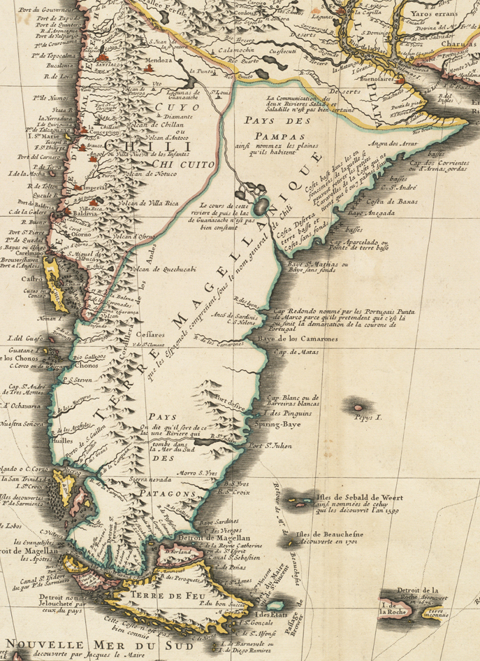
Zoom into this map at maps.bpl.org. Author: L'Isle, Guillaume de Publisher: Covens, Jean & Corneille Mortier Date: 1721 Location: Argentina, Chile, Paraguay, South America, Strait of Magellan (Chile and Argentina), Uruguay Dimension 47x56cm Scale: [ca. 1:93,442] Call Number: G5200 1721 .L57 |
| Date | |
| Source |
Carte du Paraguay, du Chili, du Detroit de Magellan &c.
|
| Author | http://maps.bpl.org |
| Other versions |
.jpg)
Licensing
[edit]_in_Carte_du_Paraguay,_du_Chili,_du_Detroit_de_Magellan.jpg&action=edit§ion=1)
This file is licensed under the Creative Commons Attribution 2.0 Generic license.
- You are free:
- to share – to copy, distribute and transmit the work
- to remix – to adapt the work
- Under the following conditions:
- attribution – You must give appropriate credit, provide a link to the license, and indicate if changes were made. You may do so in any reasonable manner, but not in any way that suggests the licensor endorses you or your use.
File history
Click on a date/time to view the file as it appeared at that time.
| Date/Time | Thumbnail | Dimensions | User | Comment | |
|---|---|---|---|---|---|
| current | 15:29, 1 January 2023 | | 687 × 945 (895 KB) | Janitoalevic (talk | contribs) | File:Carte du Paraguay, du Chili, du Detroit de Magellan &c. (4586557571).jpg cropped 66 % horizontally, 44 % vertically using CropTool with precise mode. |
You cannot overwrite this file.
File usage on Commons
The following page uses this file:
File usage on other wikis
The following other wikis use this file:
- Usage on es.wikipedia.org
_in_Carte_du_Paraguay,_du_Chili,_du_Detroit_de_Magellan.jpg&oldid=825714019)