File:Tennessee 1-50,000. Fort Campbell military installation map LOC 2010594744.jpg
Jump to navigation
Jump to search

Size of this preview: 795 × 600 pixels. Other resolutions: 318 × 240 pixels | 636 × 480 pixels | 1,018 × 768 pixels | 1,280 × 966 pixels | 2,560 × 1,932 pixels | 12,249 × 9,242 pixels.
Original file (12,249 × 9,242 pixels, file size: 21.21 MB, MIME type: image/jpeg)
Captions
Captions
Add a one-line explanation of what this file represents
Summary
[edit]| Warning | The original file is very high-resolution. It might not load properly or could cause your browser to freeze when opened at full size. |
|---|
| Description |
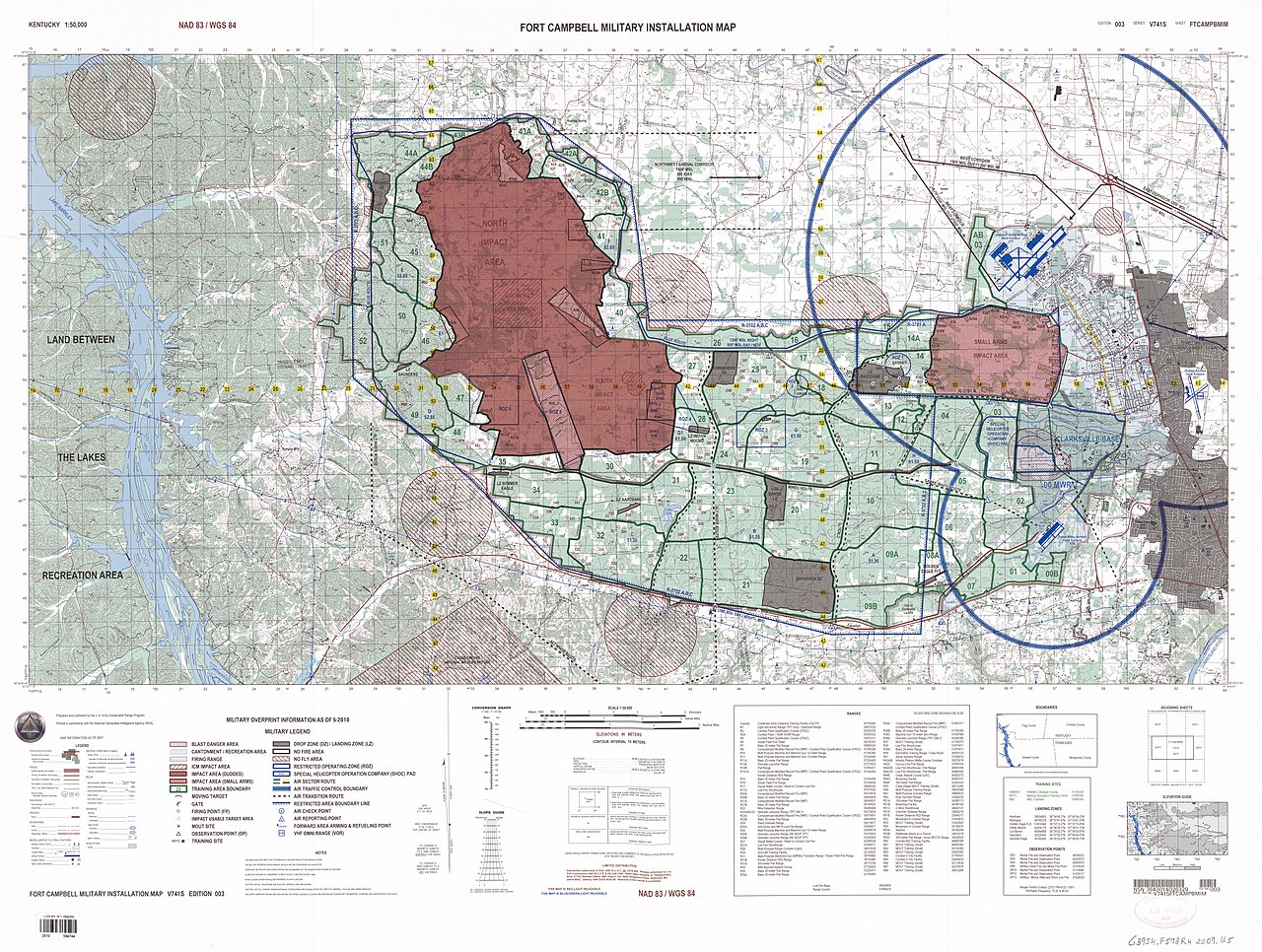
English: "Map information as of 2007 ... Military overprint information ... 2010." Relief shown by contours and spot heights. "Printed in partnership with the National-Geospatial-Intelligence Agency (NGA)." Includes notes, elevation guide, index map, conversion graph, boundary diagram, and list of military ranges. Available also through the Library of Congress Web site as a raster image. |
||
| Title | Tennessee 1:50,000. Fort Campbell military installation map | ||
| Shelf ID | G3954.F578R4 2007 .U5 | ||
| Date | |||
| Source | https://www.loc.gov/item/2010594744/ | ||
| Author | United States. Army. Sustainable Range Program; United States. National Geospatial-Intelligence Agency | ||
| Permission (Reusing this file) |
|
||
| Other versions |
|
||
| Location | Kentucky · United States · Tennessee · Fort Campbell Region. · Fort Campbell · Fort Campbell Region | ||
| Part of | American Memory · General Maps · Catalog · Geography And Map Division | ||
| Subject | Military Maps · Military Training Camps · Topographic Maps · Kentucky · United States · Maps · Tennessee · Fort Campbell (Ky. And Tenn.) · Fort Campbell Region |

Licensing
[edit]
| This work is from the Library of Congress. According to the library, there are no known copyright restrictions on the use of this work. |  |
File history
Click on a date/time to view the file as it appeared at that time.
| Date/Time | Thumbnail | Dimensions | User | Comment | |
|---|---|---|---|---|---|
| current | 22:25, 19 May 2019 | | 12,249 × 9,242 (21.21 MB) | Fæ (talk | contribs) | LOC Maps https://www.loc.gov/item/2010594744/ #2310 |
You cannot overwrite this file.
File usage on Commons
The following page uses this file: