File:Temple de Mercure - borne miliaire.jpg
Jump to navigation
Jump to search

Size of this preview: 450 × 600 pixels. Other resolutions: 180 × 240 pixels | 360 × 480 pixels | 576 × 768 pixels | 768 × 1,024 pixels | 2,112 × 2,816 pixels.
Original file (2,112 × 2,816 pixels, file size: 1.6 MB, MIME type: image/jpeg)
Captions
Captions
Add a one-line explanation of what this file represents
Summary
[edit]
| Description |
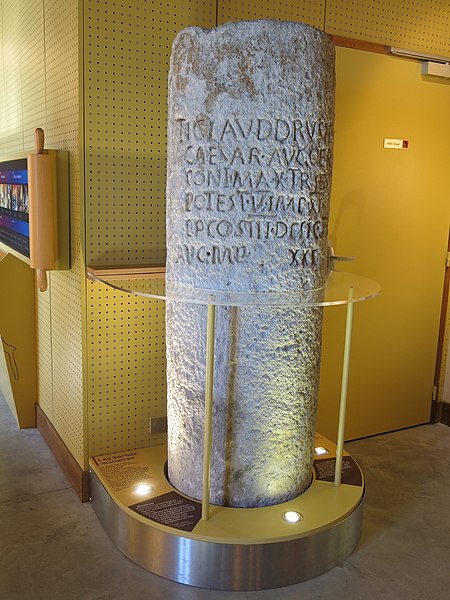
TI(BERIUS) CLAUD(IUS), DRUSI F(ILIUS)
CAESAR, AUG(USTUS), GER(MANICUS),
PONT(IFEX) MAX(IMUS), TRIB(UNICIA)
POTEST(ATE) V, IMP(ERATOR) XI
P(ATER) P(ATRIAE), CO(N)S(UL) III,
DESIG(NATUS) IV,
AUG(USTONEMETO), M(ILIA) P(ASSUUM) XXI.
Cf. Michel Provost, Christine Mennessier-Jouannet, Carte archéologique de la Gaule 63-2 : Le Puy-de-Dôme, Paris, 1994, p. 206 et 318 (mention avec copie au château d'Aulteribe) ; Gerold Walser, CIL XVII-2, 1986, inscr. 349 (CIL XVII2, 00349).
English: Roman milestone preserved in the espace du temple de Mercure (Puy-de-Dôme, France). The text is Tiberius Claudius Cesar Auguste Germanicus, son of Drusus, supreme pontif, holder of his fifth Tribunician Power, eleven times acclaimed emperor, father of the country, three times consul, consul designate for the fourth time. Augustonemetum twenty-one thousand steps.
Français : Borne miliaire conservée à l'espace du temple de Mercure (Puy-de-Dôme). Gravée en 45-46 ap. J.-C., elle se trouvait en 1607 sur la voie romaine Lyon-Saintes à Billom (CIL XIII, 8909), Neuville (archeolyon ?) ou Sermentizon (copie), dans le Puy-de-Dôme, à 21.000 pas de Clermont-Ferrand (Augustonemetum). Le texte est : Tiberius Claudius Cesar Auguste Germanicus, fils de Drusus, grand pontife, titulaire de sa cinquième puissance tribunicienne, salué empereur onze fois, père de la patrie, consul trois fois, désigné pour la quatrième fois. D'Augustonemetum vingt et un mille pas. |
| Date | |
| Source | Self-photographed |
| Author | Tangopaso |
- Original au temple de Mercure du puy de Dôme
| Object location | | View this and other nearby images on: OpenStreetMap |
|---|
- Copie au château d'Aulteribe
| Object location | | View this and other nearby images on: OpenStreetMap |
|---|
Licensing
[edit]
| I, the copyright holder of this work, release this work into the public domain. This applies worldwide. In some countries this may not be legally possible; if so: I grant anyone the right to use this work for any purpose, without any conditions, unless such conditions are required by law. |
File history
Click on a date/time to view the file as it appeared at that time.
| Date/Time | Thumbnail | Dimensions | User | Comment | |
|---|---|---|---|---|---|
| current | 21:16, 17 December 2014 | | 2,112 × 2,816 (1.6 MB) | Tangopaso (talk | contribs) | =={{int:filedesc}}== {{Information |description= <center> TI(BERIUS) CLAUD(IUS), DRUSI F(ILIUS) CAESAR, AUG(USTUS), GER(MANICUS), PONT(IFEX) MAX(IMUS), TRIB(UNICIA) POTEST(ATE) V, IMP(ERATOR) XI P(ATER) P(ATRIAE), CO(N)S(UL) III, DESIG(NATUS) IV,... |
You cannot overwrite this file.
File usage on Commons
The following page uses this file: