File:Templat Peta-id.svg
Jump to navigation
Jump to search

Size of this PNG preview of this SVG file: 440 × 600 pixels. Other resolutions: 176 × 240 pixels | 352 × 480 pixels | 563 × 768 pixels | 751 × 1,024 pixels | 1,502 × 2,048 pixels | 1,100 × 1,500 pixels.
Original file (SVG file, nominally 1,100 × 1,500 pixels, file size: 274 KB)
Captions
Captions
Add a one-line explanation of what this file represents
| Description |
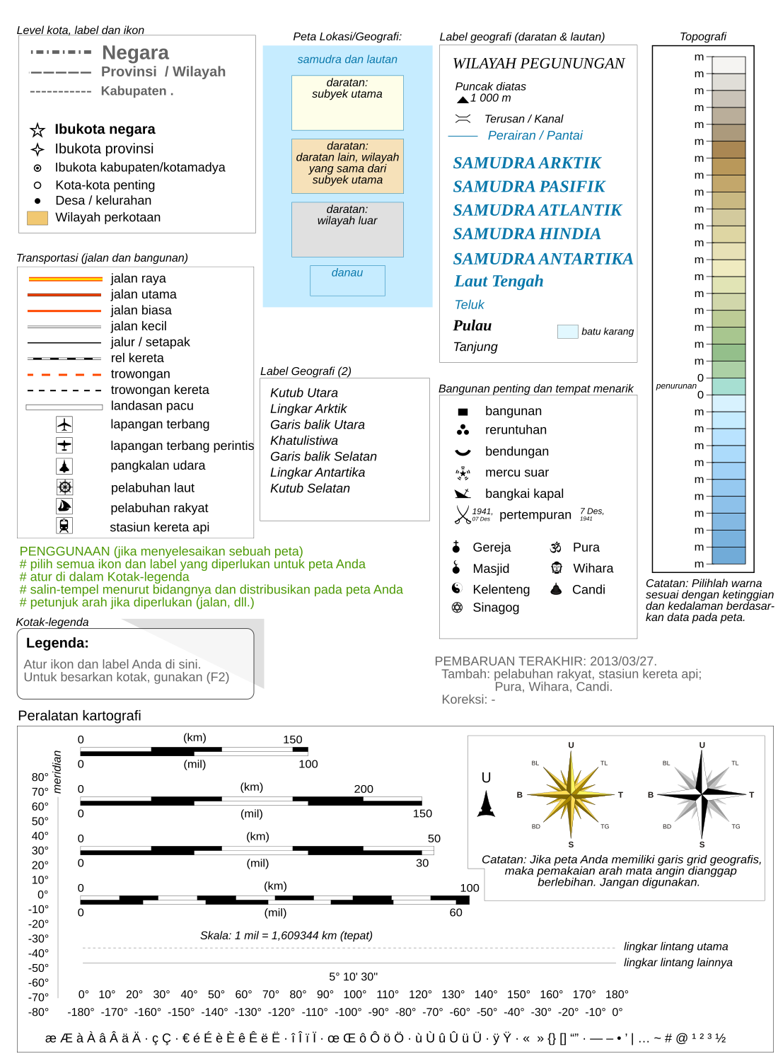
Bahasa Indonesia: Templat untuk pembuatan peta geografis dan topografi dengan fitur yang paling umum digunakan, mengikuti konvensi saat ini di WP-fr.
English: Template for the creation of geographic and topographic maps with the most common features used, following the current convention in WP-fr, and for some elements also in part of WP-de.
Français : Modèle pour la création de cartes géographiques et topographiques avec les principaux éléments habituellement employés et qui suit les conventions cartographiques actuelles de WP-fr et pour certains éléments en partie dans WP-de.
Русский: Шаблон для создания географических и топографических карт. |
| Date | |
| Source | Maps template-fr.svg |
| Author |
|
| Permission (Reusing this file) |
I, the copyright holder of this work, hereby publish it under the following license: This file is licensed under the Creative Commons Attribution 3.0 Unported license.
|
| Other versions |
English: Versions of the Maps template, a toolbox helping wiki-mapmakers and contains icons and formatted text/objects that serve as a template for Wikipedia map conventions. The French version is the 'mother one', the first to be updated, and is frequently improved and updated following calm talks between mapmakers. Experienced cartographers may propose (using English) a new icon on this talkpage.
|


| This is a retouched picture, which means that it has been digitally altered from its original version. Modifications: translation, reorganisation. The original can be viewed here: Maps template-fr.svg:
|
Original upload log[edit]
This image is a derivative work of the following images:
- File:Maps template-fr.svg licensed with cc-by-2.5, GFDL
- 2009-03-08T09:53:58Z Sémhur 1100x1500 (220266 Bytes) 13 - Change port icon (anchor), + all the fonts are now in DejaVu (Sans or Serif) Condensed.
- 2009-02-04T18:08:38Z Sting 1100x1500 (218741 Bytes) Fonts modified to the MediaWiki supported DejaVu type
- 2009-01-27T13:06:03Z Yug 1100x1500 (203738 Bytes) MINOR UPDATES: 2009/01/27. Add: port ; bat. judaisme, bat. chinese religions. Correct: terre principal fefee4 -> fefee9 (german usage) Add frames' titles, legend box. Move frames to more suitable place.
- 2008-09-04T00:08:14Z Sting 1100x1500 (176632 Bytes) Several little improvements
- 2008-07-15T14:45:27Z Sting 1100x1500 (170548 Bytes) Some improvements
- 2008-06-24T01:02:19Z Sting 1100x1500 (170673 Bytes) Valors for elevations and depths deleted to avoid confusion
- 2008-06-23T18:53:20Z Sémhur 1100x1500 (170836 Bytes) Change lighthouse icon, and decrease weight
- 2008-06-22T14:26:16Z Sting 1100x1500 (209351 Bytes) Additional topo colors for high elevations/permanent snow areas
- 2008-06-18T13:06:33Z Sting 1100x1500 (202960 Bytes) Additional modifications
- 2008-06-17T02:19:19Z Sting 1100x1500 (202606 Bytes) Some slight modifications
- 2008-06-13T14:51:52Z Sting 1100x1500 (202325 Bytes) Linear scales reduced to one type
- 2008-06-11T22:30:44Z Sting 1100x1500 (331785 Bytes) Some adjustments
- 2008-06-11T03:57:09Z Sting 1100x1500 (324893 Bytes) == Summary == {{Information |Description={{en|Template for the creation of geographic and topographic maps with the most common features used and following the convention to be used in the whole Wikimedia projet. *'''''Import
File history
Click on a date/time to view the file as it appeared at that time.
| Date/Time | Thumbnail | Dimensions | User | Comment | |
|---|---|---|---|---|---|
| current | 13:57, 27 March 2013 | | 1,100 × 1,500 (274 KB) | Iwan Novirion (talk | contribs) | {{Information |Description= {{id|Templat untuk pembuatan peta geografis dan topografi dengan fitur yang paling umum digunakan, mengikuti konvensi saat ini di WP-fr.}} {{en|Template for the creation of geographic and topographic maps with the most commo... |
You cannot overwrite this file.
File usage on Commons
The following 7 pages use this file:
File usage on other wikis
The following other wikis use this file:
- Usage on id.wikipedia.org