File:Telefoondistrict alkmaar ca 1952.svg
Jump to navigation
Jump to search

Size of this PNG preview of this SVG file: 558 × 599 pixels. Other resolutions: 223 × 240 pixels | 447 × 480 pixels | 715 × 768 pixels | 954 × 1,024 pixels | 1,907 × 2,048 pixels | 977 × 1,049 pixels.
Original file (SVG file, nominally 977 × 1,049 pixels, file size: 493 KB)
Captions
Captions
Add a one-line explanation of what this file represents
Summary[edit]
| Description |
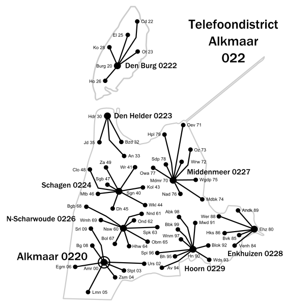
English: Schematic map of the Alkmaar telephone district, 1950s. The district exchange is located in Alkmaar, which is connected to eight node exchanges (one of them in the district exchange). These in turn are connected to the terminal exchanges to which the subscribers are connected.
Nederlands: Schematische kaart van telefoondistrict Alkmaar, jaren 1950. In Alkmaar bevindt zich de districtcentrale, die verbonden is met 8 knooppuntcentrales (een ervan in de districtscentrale). Deze zijn op hun beurt weer verbonden met de eindcentrales waarop de abonnees zijn aangesloten.
日本語: 1950年代のアルクマール電話地区の概略図。地区取引所はアルクマールにあり、8つの取引所(そのうちの1つは地区取引所にあります)に接続されています。 これらは、加入者が接続されている端末交換に接続されます。 |
| Date |
1950s |
| Source | Own work |
| Author | Pbech |
| SVG development |
Licensing[edit]
| I, the copyright holder of this work, release this work into the public domain. This applies worldwide. In some countries this may not be legally possible; if so: I grant anyone the right to use this work for any purpose, without any conditions, unless such conditions are required by law. |
File history
Click on a date/time to view the file as it appeared at that time.
| Date/Time | Thumbnail | Dimensions | User | Comment | |
|---|---|---|---|---|---|
| current | 21:47, 7 November 2008 | | 977 × 1,049 (493 KB) | Pbech (talk | contribs) | Complete revision, links between zone exchange and node exchanges omitted for clarity, added numbers of local exchanges. Volledig herzien, verbindingen districtcentrale-knoppuntcentrales weggelaten voor de duidelijkheid, nummers van eindcentrales toegevoe |
| 02:37, 7 November 2008 |  | 577 × 585 (146 KB) | Pbech (talk | contribs) | Converted all text to curves | |
| 02:35, 7 November 2008 |  | 577 × 585 (121 KB) | Pbech (talk | contribs) | == Summary == {{Information |Description={{en|1=Schematic map of Dutch PTT telephone district Alkmaar, 1950s. }} {{nl|1=Schematische kaart van telefoondistrict Alkmaar, jaren 1950. In Alkmaar bevindt zich de districtcentrale, die verbonden is met 8 knoopp |
You cannot overwrite this file.
File usage on Commons
There are no pages that use this file.
File usage on other wikis
The following other wikis use this file:
- Usage on nl.wikipedia.org