File:Tavernier - France postal route map 1632.jpg
Jump to navigation
Jump to search

Size of this preview: 770 × 599 pixels. Other resolutions: 308 × 240 pixels | 617 × 480 pixels | 987 × 768 pixels | 1,280 × 996 pixels | 2,560 × 1,993 pixels | 4,262 × 3,318 pixels.
Original file (4,262 × 3,318 pixels, file size: 14.49 MB, MIME type: image/jpeg)
Captions
Captions
Add a one-line explanation of what this file represents
Summary[edit]
| Description |
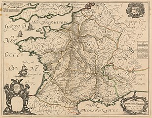
English: “Carte géographicque des postes qui trauersent la France” (Paris: Par Melchior Tauernier . . . , 1632). Copperplate map, with added outline color, 41 × 52 cm [Historic Maps Collection].
First postal road map—also the first important map issued by Sanson. The map shows all of the routes used by the royal posts of the time, identifying the stops along the way; it was reprinted many times during the seventeenth century. Curiously, the cartouche for the dedication has been left blank. The French postal system dates back to 1477, when King Louis XI set up a Royal Postal Service that employed mounted couriers. The timing of this map is relevant, for private mail delivery had just been legalized several years earlier (1627), so both services were operating over the same major routes. In 1672, France made postal service a government-only function. |
|||||||||||||||||||||||||
| Date | ||||||||||||||||||||||||||
| Source | http://libweb5.princeton.edu/visual_materials/maps/websites/thematic-maps/qualitative/sanson-map-1632.jpg linked from this webpage | |||||||||||||||||||||||||
| Author |
|
|||||||||||||||||||||||||
Licensing[edit]
|
This is a faithful photographic reproduction of a two-dimensional, public domain work of art. The work of art itself is in the public domain for the following reason:
The official position taken by the Wikimedia Foundation is that "faithful reproductions of two-dimensional public domain works of art are public domain".
This photographic reproduction is therefore also considered to be in the public domain in the United States. In other jurisdictions, re-use of this content may be restricted; see Reuse of PD-Art photographs for details. | ||||
File history
Click on a date/time to view the file as it appeared at that time.
| Date/Time | Thumbnail | Dimensions | User | Comment | |
|---|---|---|---|---|---|
| current | 22:20, 8 April 2018 | | 4,262 × 3,318 (14.49 MB) | Ww2censor (talk | contribs) | == {{int:filedesc}} == {{Information |Description={{en|“Carte géographicque des postes qui trauersent la France” (Paris: Par Melchior Tauernier . . . , 1632). Copperplate map, with added outline color, 41 × 52 cm [Historic Maps Collection]. First postal road map—also the first important map issued by Sanson. The map shows all of the routes used by the royal posts of the time, identifying the stops along the way; it was reprinted many times during the seventeenth century. Curiously, the cart... |
You cannot overwrite this file.
File usage on Commons
The following 2 pages use this file: