File:Tasmania-satellite.jpg
Jump to navigation
Jump to search

Size of this preview: 671 × 600 pixels. Other resolutions: 269 × 240 pixels | 537 × 480 pixels | 860 × 768 pixels | 1,146 × 1,024 pixels | 1,343 × 1,200 pixels.
Original file (1,343 × 1,200 pixels, file size: 146 KB, MIME type: image/jpeg)
Captions
Captions
Add a one-line explanation of what this file represents
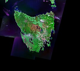
Tasmania viewed from satellite Landsat
Landsat satellite photo of the island of Tasmania.
| This file is in the public domain in the United States because it was solely created by NASA. NASA copyright policy states that "NASA material is not protected by copyright unless noted". (See Template:PD-USGov, NASA copyright policy page or JPL Image Use Policy.) | ||
 |
Warnings:
|
File history
Click on a date/time to view the file as it appeared at that time.
| Date/Time | Thumbnail | Dimensions | User | Comment | |
|---|---|---|---|---|---|
| current | 15:45, 12 December 2004 | | 1,343 × 1,200 (146 KB) | Mschlindwein (talk | contribs) | Tasmania viewed from satellite |
You cannot overwrite this file.
File usage on Commons
The following 3 pages use this file:
File usage on other wikis
The following other wikis use this file:
- Usage on bo.wikipedia.org
- Usage on de.wikipedia.org
- Usage on en.wikipedia.org
- Usage on fi.wikipedia.org
- Usage on fr.wikipedia.org
- Usage on gl.wikipedia.org
- Usage on is.wikipedia.org
- Usage on kn.wikipedia.org
- Usage on nn.wikipedia.org
- Usage on oc.wikipedia.org
- Usage on pt.wikipedia.org
- Usage on sco.wikipedia.org
- Usage on sh.wikipedia.org
- Usage on sv.wikipedia.org
- Usage on zh.wikipedia.org