File:Tancheon Location Map-ar.png
Jump to navigation
Jump to search

Size of this preview: 758 × 599 pixels. Other resolutions: 304 × 240 pixels | 607 × 480 pixels | 955 × 755 pixels.
Original file (955 × 755 pixels, file size: 43 KB, MIME type: image/png)
Captions
Captions
Add a one-line explanation of what this file represents
Summary[edit]
| Description |
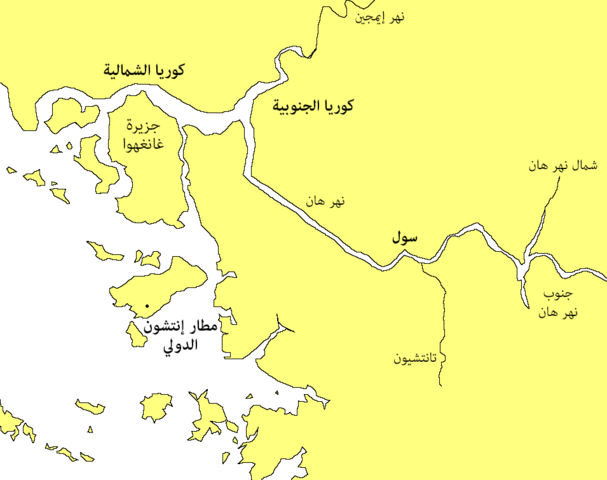
العربية: خارطة الموقع الجغرافي لتانتشيون
English: Tancheon Location Map |
| Date | |
| Source | Derivative from this file |
| Author |
Original:User:Jpbarrass. Derivative: User:Moataz1997 |
| Other versions | English |
| This is a retouched picture, which means that it has been digitally altered from its original version. Modifications: Translated to Arabic - عُرِبَت. Modifications made by Moataz1997.
|
Licensing[edit]
| This work has been released into the public domain by its author, Jpbarrass at English Wikipedia. This applies worldwide. In some countries this may not be legally possible; if so: Jpbarrass grants anyone the right to use this work for any purpose, without any conditions, unless such conditions are required by law. |
Original upload log[edit]
The original description page was here. All following user names refer to en.wikipedia.
- 2007-05-22 16:54 Jpbarrass 955×755×8 (40589 bytes) Location of the Tancheon (Stream)
File history
Click on a date/time to view the file as it appeared at that time.
| Date/Time | Thumbnail | Dimensions | User | Comment | |
|---|---|---|---|---|---|
| current | 18:15, 18 October 2016 | | 955 × 755 (43 KB) | Moataz1997 (talk | contribs) | User created page with UploadWizard |
You cannot overwrite this file.
File usage on Commons
There are no pages that use this file.
File usage on other wikis
The following other wikis use this file:
- Usage on ar.wikipedia.org