File:Taman Nasional Rawa Aopa Watumohai - Kenangan Tentang Rawaku.jpg
Jump to navigation
Jump to search

Size of this preview: 800 × 600 pixels. Other resolutions: 320 × 240 pixels | 640 × 480 pixels | 1,024 × 768 pixels | 1,280 × 960 pixels | 2,560 × 1,920 pixels | 4,000 × 3,000 pixels.
Original file (4,000 × 3,000 pixels, file size: 6.48 MB, MIME type: image/jpeg)
Captions
Captions
A memories of My Swamp
Summary[edit]
| Description |
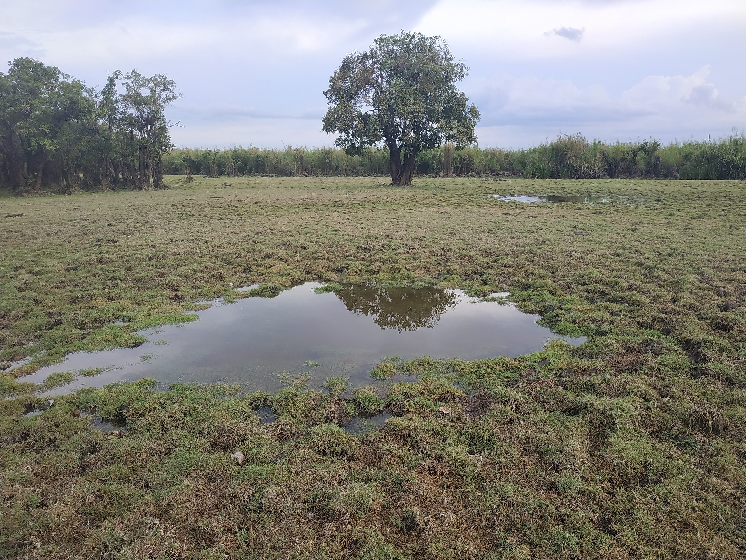
English: Memories of My Swamp
Rawa Aopa Watumohai Puriala National Park, Konawe Regency, Southeast Sulawesi on December 23, 2019 ago. A few years ago, the area around was still filled with water but now there is only a small puddle that reminds me of what this place was like. Fish live under tree roots which are inundated by water and birds nest on its branches. But now all that's left is a small pond. The destruction of nature by humans and the long drought becomes the main reason of this such horrible situation. The opening up of oil palm plantations and climate change might allow some adapted species to survive for a period of time, but it does not mean forever.
Bahasa Indonesia: Kenangan Tentang Rawaku
Taman Nasional Rawa Aopa Watumohai Puriala, Kabupaten Konawe, Sulawesi Tenggara pada 23 Desember 2019 silam. Beberapa waktu yang lalu area disekitar Rawa ini masih dipenuhi dengan air namun kini tinggal genangan kecil yang mengingatkanku tentang seperti apa tempat ini dahulu. Ikan-ikan hidup di bawah akar-akar pohon yang tergenang oleh air dan burung burung bersarang diatas ranting-ranting. Namun kini yang tersisa hanya sebuah kolam kecil ini. Perusakan alam oleh manusia lah yang menjadi penyebab utama hal ini bisa terjadi. Pembukaan area perkebunan sawit serta perubahan iklim terus menyusutkan keberadaan rawa. Hal ini mungkin akan membiarkan beberapa spesies yang dapat beradatasi untuk tetap hidup selama beberapa waktu, tapi tidak untuk selamanya. |
| Date | |
| Source | Own work |
| Author | EfraimJF |
| Camera location | | View this and other nearby images on: OpenStreetMap |
|---|
Many people in Indonesia struggle about the rights of local communities to the entry of large companies that do not have a good impact on the surrounding population
Licensing[edit]
I, the copyright holder of this work, hereby publish it under the following license:
This file is licensed under the Creative Commons Attribution-Share Alike 4.0 International license.
- You are free:
- to share – to copy, distribute and transmit the work
- to remix – to adapt the work
- Under the following conditions:
- attribution – You must give appropriate credit, provide a link to the license, and indicate if changes were made. You may do so in any reasonable manner, but not in any way that suggests the licensor endorses you or your use.
- share alike – If you remix, transform, or build upon the material, you must distribute your contributions under the same or compatible license as the original.
This image was uploaded as part of Wiki Loves Earth 2020.
|
 |
File history
Click on a date/time to view the file as it appeared at that time.
| Date/Time | Thumbnail | Dimensions | User | Comment | |
|---|---|---|---|---|---|
| current | 09:01, 20 May 2020 | | 4,000 × 3,000 (6.48 MB) | EfraimJF (talk | contribs) | Uploaded own work with UploadWizard |
You cannot overwrite this file.
File usage on Commons
There are no pages that use this file.
File usage on other wikis
The following other wikis use this file:
- Usage on ban.wikipedia.org
- Usage on de.wikipedia.org
- Usage on id.wikipedia.org