File:TT Samba.png
Jump to navigation
Jump to search

Size of this preview: 600 × 600 pixels. Other resolutions: 240 × 240 pixels | 480 × 480 pixels | 768 × 768 pixels | 1,024 × 1,024 pixels | 1,358 × 1,358 pixels.
Original file (1,358 × 1,358 pixels, file size: 588 KB, MIME type: image/png)
Captions
Captions
Add a one-line explanation of what this file represents
Summary[edit]
| Description |
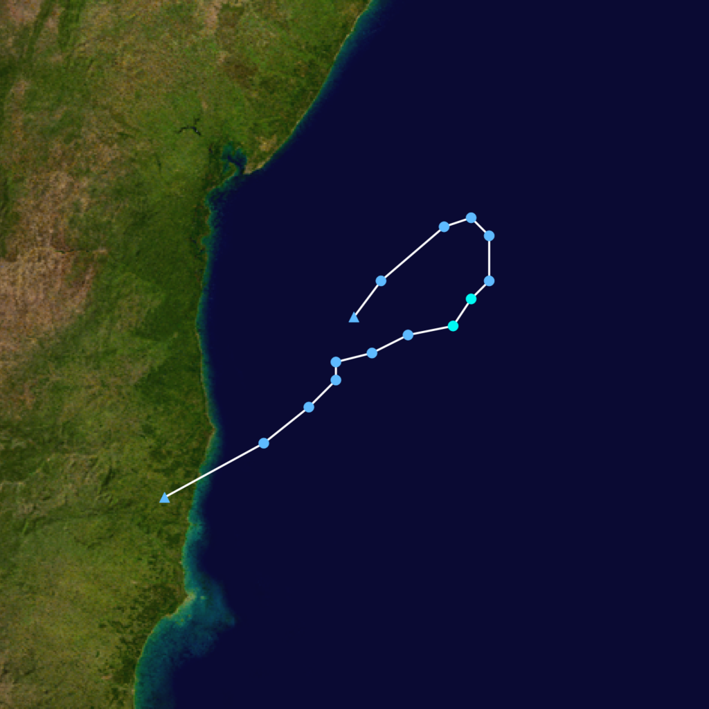
Español: Imagen que muestra el recorrido de la tormenta tropical Samba en enero de 2004 |
| Date | |
| Source | Trabajo propio, utilizando reanálisis ERA5 e información de Australia Severe Weather |
| Author | Luxin1989 |
Summary
| Description |
English: Español: Esta figura muestra la trayectoria de la tormenta tropical Samba. Los puntos muestran la ubicación cada 6 horas. Los colores representan la intensidad máxima sostenida del viento según la escala de huracanes Saffir-Simpson y los símbolos representan el tipo del ciclón Tropical depression (≤38 mph, ≤62 km/h)
Tropical storm (39–73 mph, 63–118 km/h)
Category 1 (74–95 mph, 119–153 km/h)
Category 2 (96–110 mph, 154–177 km/h)
Category 3 (111–129 mph, 178–208 km/h)
Category 4 (130–156 mph, 209–251 km/h)
Category 5 (≥157 mph, ≥252 km/h)
Unknown
Storm type |
| Date | 18/01/2004–21/01/2004 |
| Source | Created by Luxin1989 using Wikipedia:WikiProject Tropical cyclones/Tracks. The background image is from NASA. Tracking data is from Own work, using ERA5 reanalysis and information of Australia Severe Weather. |
| Author | Luxin1989 |
Licensing[edit]
| This work has been released into the public domain by its author, Luxin1989. This applies worldwide. In some countries this may not be legally possible; if so: Luxin1989 grants anyone the right to use this work for any purpose, without any conditions, unless such conditions are required by law. |
Licensing[edit]
I, the copyright holder of this work, hereby publish it under the following license:
This file is licensed under the Creative Commons Attribution-Share Alike 4.0 International license.
- You are free:
- to share – to copy, distribute and transmit the work
- to remix – to adapt the work
- Under the following conditions:
- attribution – You must give appropriate credit, provide a link to the license, and indicate if changes were made. You may do so in any reasonable manner, but not in any way that suggests the licensor endorses you or your use.
- share alike – If you remix, transform, or build upon the material, you must distribute your contributions under the same or compatible license as the original.
File history
Click on a date/time to view the file as it appeared at that time.
| Date/Time | Thumbnail | Dimensions | User | Comment | |
|---|---|---|---|---|---|
| current | 00:06, 26 October 2022 | | 1,358 × 1,358 (588 KB) | Luxin1989 (talk | contribs) | Recorrido actualizado, usando imágenes satelitales y el software WCT de la NOAA |
| 01:34, 1 August 2022 |  | 2,038 × 2,038 (758 KB) | Luxin1989 (talk | contribs) | Uploaded own work with UploadWizard |
You cannot overwrite this file.
File usage on Commons
There are no pages that use this file.
File usage on other wikis
The following other wikis use this file:
- Usage on es.wikipedia.org
- Usage on pt.wikipedia.org
- Usage on vi.wikipedia.org