File:TTCsubwayRTmap-2015.png
Jump to navigation
Jump to search

Size of this preview: 800 × 478 pixels. Other resolutions: 320 × 191 pixels | 640 × 383 pixels | 831 × 497 pixels.
Original file (831 × 497 pixels, file size: 113 KB, MIME type: image/png)
Captions
Captions
Add a one-line explanation of what this file represents
Summary
[edit]
| Description |
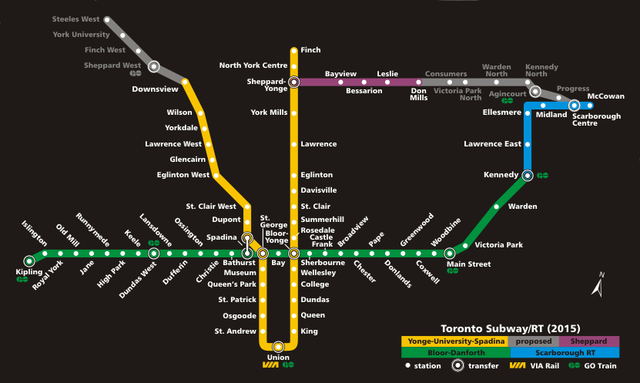
Toronto TTC subway/RT map: proposed (2015) Created by E Pluribus Anthony |
| Date | 16 October 2005 (original upload date) |
| Source | No machine-readable source provided. Own work assumed (based on copyright claims). |
| Author | No machine-readable author provided. E Pluribus Anthony~commonswiki assumed (based on copyright claims). |
Licensing
[edit]
| I, the copyright holder of this work, release this work into the public domain. This applies worldwide. In some countries this may not be legally possible; if so: I grant anyone the right to use this work for any purpose, without any conditions, unless such conditions are required by law. |
File history
Click on a date/time to view the file as it appeared at that time.
| Date/Time | Thumbnail | Dimensions | User | Comment | |
|---|---|---|---|---|---|
| current | 16:25, 5 May 2020 | | 831 × 497 (113 KB) | Leonel Sohns (talk | contribs) | Removed border. |
| 06:13, 20 October 2005 |  | 831 × 497 (104 KB) | E Pluribus Anthony~commonswiki (talk | contribs) | TTC subway/RT map: proposed (2015) | |
| 00:32, 19 October 2005 |  | 831 × 497 (104 KB) | E Pluribus Anthony~commonswiki (talk | contribs) | TTC subway/RT map: proposed (2015) | |
| 12:05, 18 October 2005 |  | 831 × 497 (107 KB) | E Pluribus Anthony~commonswiki (talk | contribs) | TTC subway/RT map: proposed (2015) | |
| 18:45, 16 October 2005 |  | 831 × 497 (107 KB) | E Pluribus Anthony~commonswiki (talk | contribs) | TTC subway/RT map: proposed (2015) |
You cannot overwrite this file.
File usage on Commons
The following 3 pages use this file: