File:Szczecinek (gmina wiejska) location map.png
Jump to navigation
Jump to search

Size of this preview: 406 × 599 pixels. Other resolutions: 163 × 240 pixels | 325 × 480 pixels | 894 × 1,318 pixels.
Original file (894 × 1,318 pixels, file size: 177 KB, MIME type: image/png)
Captions
Captions
Add a one-line explanation of what this file represents
| Description |
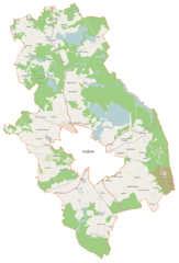
Polski: Mapa gminy Szczecinek, Polska
English: Map of Gmina Szczecinek, Poland |
|||||||||
| Date | ||||||||||
| Source | You may find a page on the OpenStreetMap wiki page for Szczecinek (gmina wiejska) | |||||||||
| Creator |
OpenStreetMap contributors OpenStreetMap contributors |
|||||||||
| Permission (Reusing this file) |
OpenStreetMap data is available under the Open Database License (details). Map tiles are licensed under the Creative Commons Attribution-ShareAlike 2.0 license (CC-BY-SA 2.0).
This file is licensed under the Creative Commons Attribution-Share Alike 2.0 Generic license.
|
|||||||||
| Geotemporal data | ||||||||||
| Bounding box |
|
|||||||||
| Georeferencing | If inappropriate please set warp_status = skip to hide. | |||||||||
File history
Click on a date/time to view the file as it appeared at that time.
| Date/Time | Thumbnail | Dimensions | User | Comment | |
|---|---|---|---|---|---|
| current | 12:39, 18 April 2015 | | 894 × 1,318 (177 KB) | VanWiel (talk | contribs) | {{OpenStreetMap | name = Szczecinek (gmina wiejska) | location = Szczecinek (gmina wiejska) | description = {{pl|Mapa gminy Szczecinek, Polska}} {{en|Map of Gmina Szczecinek, Poland}} | top = 53.9128 | bott... |
You cannot overwrite this file.
File usage on Commons
There are no pages that use this file.
File usage on other wikis
The following other wikis use this file:
- Usage on fr.wikipedia.org
- Białe (Poméranie-Occidentale)
- Drawień
- Drężno
- Dobrogoszcz (Szczecinek)
- Dalęcino
- Dębowo (Poméranie-Occidentale)
- Dębrzyna
- Dalęcinko
- Dąbrowa (Szczecinek)
- Buczek (Szczecinek)
- Brzeźno (Szczecinek)
- Grochowiska (Poméranie-Occidentale)
- Gwda Mała
- Grąbczyński Młyn
- Gołębiewo (Poméranie-Occidentale)
- Grąbczyn
- Godzimierz (Poméranie-Occidentale)
- Dziki (Poméranie-Occidentale)
- Gałówko
- Lipnica (Poméranie-Occidentale)
- Łączka (Poméranie-Occidentale)
- Łabędź (Poméranie-Occidentale)
- Kusowo (Poméranie-Occidentale)
- Kwakowo (Poméranie-Occidentale)
- Krasnobrzeg (Poméranie-Occidentale)
- Krągłe (Poméranie-Occidentale)
- Janowo (Szczecinek)
- Jelenino (Szczecinek)
- Jadwiżyn (Szczecinek)
- Gwda Wielka
- Niedźwiady (Poméranie-Occidentale)
- Nizinne
- Myślęcin (Poméranie-Occidentale)
- Mosina (Szczecinek)
- Malechowo (Szczecinek)
- Marcelin (Poméranie-Occidentale)
- Miękowo (Szczecinek)
- Łozinka
- Łysa Góra (Poméranie-Occidentale)
- Orawka (Poméranie-Occidentale)
- Orłowce (Poméranie-Occidentale)
- Nowe Gonne
- Omulna
- Opoczyska
- Sierszeniska
- Sitno (Szczecinek)
- Siedlice (Szczecinek)
- Pietrzykowo (Poméranie-Occidentale)
- Płużyny
- Parnica (Szczecinek)
View more global usage of this file.
_location_map.png)
_location_map.png&oldid=497294921)