File:Symphyotrichum kentuckiense range.png
Jump to navigation
Jump to search
No higher resolution available.
Symphyotrichum_kentuckiense_range.png (500 × 500 pixels, file size: 212 KB, MIME type: image/png)
Captions
Captions
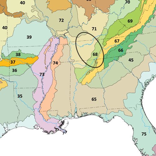
The endemic range of Symphyotrichum kentuckiense is in limestone cedar glades of Kentucky, Tennessee, Alabama, and Georgia roughly within the black oval on this map.
Summary
[edit]| Description |
English: The endemic range of Symphyotrichum kentuckiense is in limestone cedar glades of Kentucky, Tennessee, Alabama, and Georgia roughly within the black oval on this map. |
| Date | |
| Source | |
| Author | US Environmental Protection Agency (EPA) |

Licensing
[edit]
This work is in the public domain in the United States because it is a work prepared by an officer or employee of the United States Government as part of that person’s official duties under the terms of Title 17, Chapter 1, Section 105 of the US Code.
Note: This only applies to original works of the Federal Government and not to the work of any individual U.S. state, territory, commonwealth, county, municipality, or any other subdivision. This template also does not apply to postage stamp designs published by the United States Postal Service since 1978. (See § 313.6(C)(1) of Compendium of U.S. Copyright Office Practices). It also does not apply to certain US coins; see The US Mint Terms of Use.
|
 | |
| This file has been identified as being free of known restrictions under copyright law, including all related and neighboring rights. | ||
File history
Click on a date/time to view the file as it appeared at that time.
| Date/Time | Thumbnail | Dimensions | User | Comment | |
|---|---|---|---|---|---|
| current | 01:22, 3 October 2022 | | 500 × 500 (212 KB) | Eewilson (talk | contribs) | Uploaded a work by US Environmental Protection Agency (EPA) from File:Level III ecoregions, United States.png with UploadWizard |
You cannot overwrite this file.
File usage on Commons
The following page uses this file:
File usage on other wikis
The following other wikis use this file:
- Usage on en.wikipedia.org
- Usage on www.wikidata.org