File:Swedish Empire (1560-1815) es.svg
Jump to navigation
Jump to search

Size of this PNG preview of this SVG file: 604 × 600 pixels. Other resolutions: 242 × 240 pixels | 483 × 480 pixels | 773 × 768 pixels | 1,031 × 1,024 pixels | 2,062 × 2,048 pixels | 734 × 729 pixels.
Original file (SVG file, nominally 734 × 729 pixels, file size: 728 KB)
Captions
Captions
Add a one-line explanation of what this file represents
Summary[edit]
_es.svg&action=edit§ion=1)
| Description |
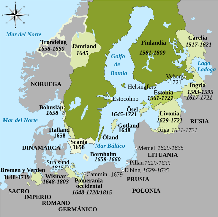
Français : Carte vectorielle montrant le développement de l'Empire Suédois en Europe du Nord entre 1560 et 1815.
Español: El Imperio sueco entre 1560 y 1815
Territorios de Gustavo I (hasta 1560)
Acquisiciones de los hijos de Gustavo I (1560-1611)
Acquisiciones de Carlos X (1654-1660)
Acquisiciones de Gustavo II Adolfo y Cristina (1611-1654) |
| Date | |
| Source | Swedish Empire (1560-1815) fr.svg |
| Author |
|
_fr.svg)
Licensing[edit]
_es.svg&action=edit§ion=2)
I, the copyright holder of this work, hereby publish it under the following license:
This file is licensed under the Creative Commons Attribution-Share Alike 4.0 International license.
- You are free:
- to share – to copy, distribute and transmit the work
- to remix – to adapt the work
- Under the following conditions:
- attribution – You must give appropriate credit, provide a link to the license, and indicate if changes were made. You may do so in any reasonable manner, but not in any way that suggests the licensor endorses you or your use.
- share alike – If you remix, transform, or build upon the material, you must distribute your contributions under the same or compatible license as the original.
File history
Click on a date/time to view the file as it appeared at that time.
| Date/Time | Thumbnail | Dimensions | User | Comment | |
|---|---|---|---|---|---|
| current | 22:28, 26 June 2020 | | 734 × 729 (728 KB) | Rowanwindwhistler (talk | contribs) | Minor change |
| 09:22, 26 June 2020 |  | 434 × 431 (716 KB) | Rowanwindwhistler (talk | contribs) | Zoomed in, colour legend removed (now in file description), new font, lighter colours for territories. | |
| 12:11, 21 June 2018 |  | 433 × 531 (736 KB) | Srittau (talk | contribs) | Reverted to version as of 09:26, 19 June 2018 (UTC) | |
| 12:03, 21 June 2018 |  | 433 × 531 (746 KB) | Srittau (talk | contribs) | Reverted to version as of 10:21, 26 September 2016 (UTC) | |
| 09:26, 19 June 2018 |  | 433 × 531 (736 KB) | Vertem (talk | contribs) | Corrección error ortográfico grave. | |
| 10:21, 26 September 2016 |  | 433 × 531 (746 KB) | Rowanwindwhistler (talk | contribs) | Error corrected (duplicated text) | |
| 10:19, 26 September 2016 |  | 433 × 531 (719 KB) | Rowanwindwhistler (talk | contribs) | https://en.wikipedia.org/wiki/Wikipedia:WikiProject_Maps/Conventions Real text hidden, fake text added | |
| 10:17, 7 August 2015 |  | 433 × 531 (225 KB) | Rowanwindwhistler (talk | contribs) | User created page with UploadWizard |
You cannot overwrite this file.
File usage on Commons
The following page uses this file:
File usage on other wikis
The following other wikis use this file:
- Usage on ast.wikipedia.org
- Usage on ca.wikipedia.org
- Usage on es.wikipedia.org
- Usage on eu.wikipedia.org
- Usage on mt.wikipedia.org
- Usage on no.wikipedia.org
- Usage on pt.wikipedia.org
- Usage on ro.wikipedia.org
- Usage on www.wikidata.org
_es.svg&oldid=606480055)