File:Streaks of Sediment in the Gulf of Khambhat (MODIS 2022-01-11).jpg

Original file (2,165 × 1,707 pixels, file size: 1.57 MB, MIME type: image/jpeg)
Captions
Captions
Summary[edit]
.jpg&action=edit§ion=1)
| Description |
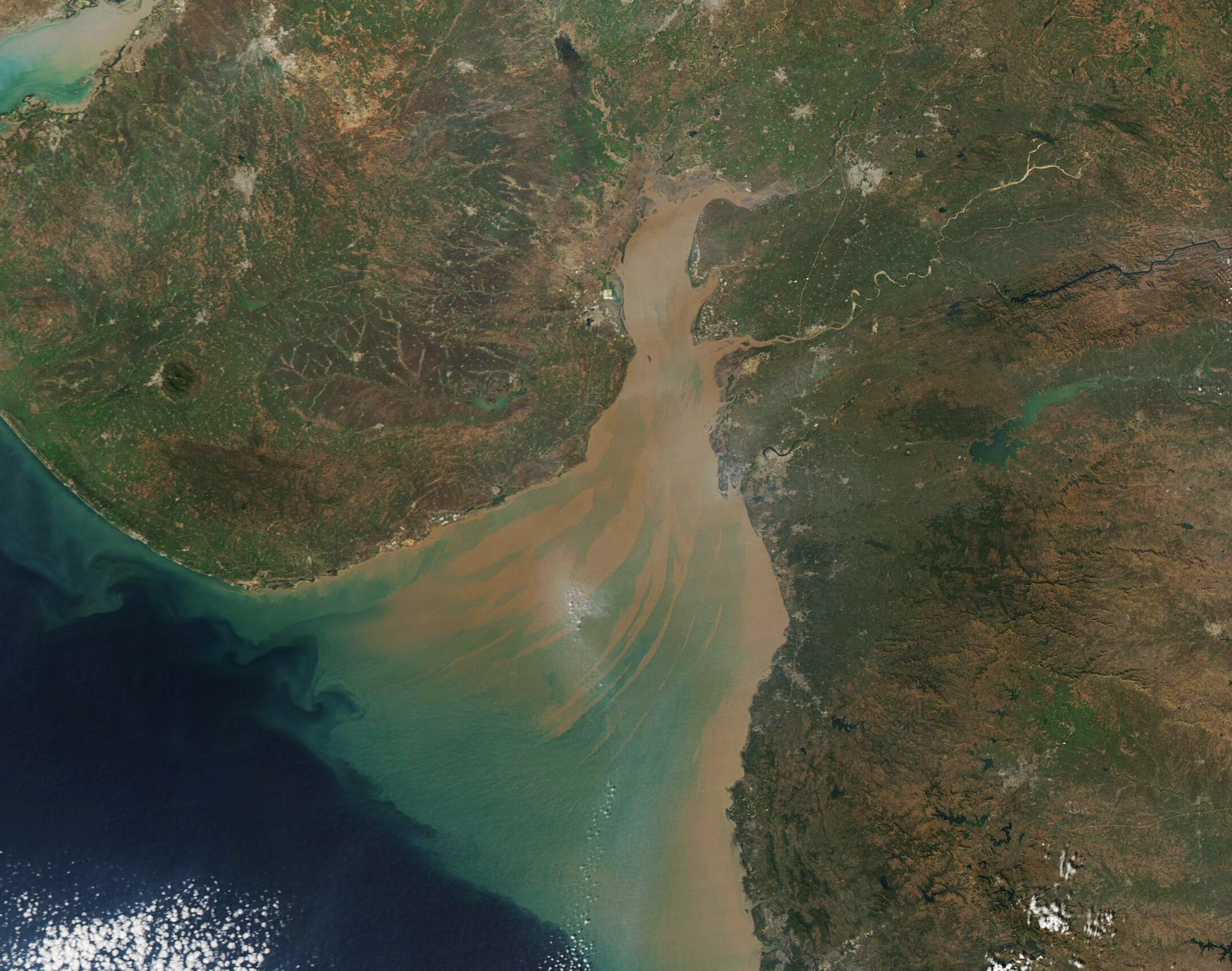
English: This gorgeous true-color image of sediment-laden water coloring the Gulf of Khambhat was acquired by the Moderate Resolution Imaging Spectroradiometer (MODIS) on board NASA’s Aqua satellite on January 10, 2022. The mud-brown sediment is thickest and nearest the surface in the northern section of the Gulf. As sediment begins to disperse and sink, the reflectivity changes and so it is seen as greenish in color. Currents leave streaks of sediment near the surface, creating a beautiful tan-and-green pattern as the waters open into the deep blue of the Arabian Sea.
The Gulf of Khambhat, which was once called the Gulf of Cambay, is a funnel-shaped indentation of the Arabian Sea that separates the large Saurashtra Peninsula and the mainland of Gujarat state, India. About 50 miles (80 km) wide at the mouth, the Gulf squeeze to a narrow 15 miles (25 km) as it courses northward. The mouth is also deeper than the northern area, with maximum water depth ranging from 98 feet (30 m) close to the Arabian Sea to 33 feet (10 m) in the north. Waters of the Gulf of Khambhat are often turbid, with sediment suspended both from the action of the tides over the shallow northern waters and from the inflow of several rivers. The Narmada, Tapi, Mahi, and Sabarmati Rivers spill into the Gulf of Khambhat, carrying both freshwater and heavy loads of suspended sediment. |
||
| Date | Taken on 10 January 2022 | ||
| Source |
Streaks of Sediment in the Gulf of Khambhat (direct link)
|
||
| Author | MODIS Land Rapid Response Team, NASA GSFC |
| This media is a product of the Aqua mission Credit and attribution belongs to the mission team, if not already specified in the "author" row |
Licensing[edit]
.jpg&action=edit§ion=2)
| This file is in the public domain in the United States because it was solely created by NASA. NASA copyright policy states that "NASA material is not protected by copyright unless noted". (See Template:PD-USGov, NASA copyright policy page or JPL Image Use Policy.) | ||
 |
Warnings:
|
File history
Click on a date/time to view the file as it appeared at that time.
| Date/Time | Thumbnail | Dimensions | User | Comment | |
|---|---|---|---|---|---|
| current | 22:22, 9 January 2024 | | 2,165 × 1,707 (1.57 MB) | OptimusPrimeBot (talk | contribs) | #Spacemedia - Upload of http://modis.gsfc.nasa.gov/gallery/images/image01112022_250m.jpg via Commons:Spacemedia |
You cannot overwrite this file.
File usage on Commons
There are no pages that use this file.
.jpg&oldid=840281460)