File:Strassenbahnnetz-Leipzig.svg
Jump to navigation
Jump to search

Size of this PNG preview of this SVG file: 800 × 570 pixels. Other resolutions: 320 × 228 pixels | 640 × 456 pixels | 1,024 × 730 pixels | 1,280 × 912 pixels | 2,560 × 1,825 pixels | 2,065 × 1,472 pixels.
Original file (SVG file, nominally 2,065 × 1,472 pixels, file size: 279 KB)
Captions
Captions
Add a one-line explanation of what this file represents
Summary[edit]
| Description |
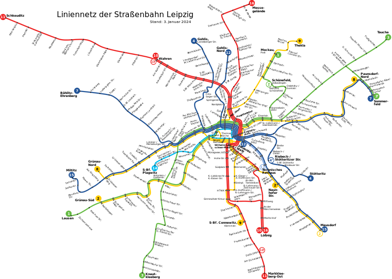
English: Map of the tram network in Leipzig, Germany as of January 3, 2024 Deutsch: Liniennetzplan der Leipziger Straßenbahn, Stand 3. Januar 2024 |
| Date | (UTC) |
| Source |
This file was derived from: Strassenbahnnetz-Leipzig 20111211.svg: |
| Author |
|
| This is a retouched picture, which means that it has been digitally altered from its original version. Modifications: Haltestelle Richard-Lehmann-Str. in HTWK umbenannt. The original can be viewed here: Strassenbahnnetz-Leipzig 20111211.svg:
|
Licensing[edit]
I, the copyright holder of this work, hereby publish it under the following licenses:
This file is licensed under the Creative Commons Attribution-Share Alike 3.0 Unported, 2.5 Generic, 2.0 Generic and 1.0 Generic license.
- You are free:
- to share – to copy, distribute and transmit the work
- to remix – to adapt the work
- Under the following conditions:
- attribution – You must give appropriate credit, provide a link to the license, and indicate if changes were made. You may do so in any reasonable manner, but not in any way that suggests the licensor endorses you or your use.
- share alike – If you remix, transform, or build upon the material, you must distribute your contributions under the same or compatible license as the original.

|
Permission is granted to copy, distribute and/or modify this document under the terms of the GNU Free Documentation License, Version 1.2 or any later version published by the Free Software Foundation; with no Invariant Sections, no Front-Cover Texts, and no Back-Cover Texts. A copy of the license is included in the section entitled GNU Free Documentation License. |
You may select the license of your choice.
Original upload log[edit]
This image is a derivative work of the following images:
- File:Strassenbahnnetz-Leipzig_20111211.svg licensed with Cc-by-sa-3.0,2.5,2.0,1.0, GFDL
- 2012-02-10T21:51:11Z Onegin 2065x1472 (290575 Bytes) == {{int:filedesc}} == {{Information |Description={{en|1=Map of the tram network in Leipzig, Germany as of December 11, 2011}} {{de|1=Liniennetzplan der Leipziger Straßenbahn, Stand 11. Dezember 2011}} |Source={{Derived from
Uploaded with derivativeFX
File history
Click on a date/time to view the file as it appeared at that time.
| Date/Time | Thumbnail | Dimensions | User | Comment | |
|---|---|---|---|---|---|
| current | 18:23, 10 January 2024 | | 2,065 × 1,472 (279 KB) | Bürgerentscheid (talk | contribs) | updated to 2024-01-03 |
| 21:46, 9 June 2022 |  | 2,065 × 1,472 (279 KB) | Bürgerentscheid (talk | contribs) | updated to 2021-11-27 | |
| 21:29, 6 December 2021 |  | 2,065 × 1,472 (283 KB) | Master Uegly (talk | contribs) | flowRoot element removed | |
| 08:20, 11 May 2016 |  | 2,065 × 1,472 (278 KB) | Bürgerentscheid (talk | contribs) | defs cleaned��� | |
| 08:14, 11 May 2016 |  | 2,065 × 1,472 (279 KB) | Bürgerentscheid (talk | contribs) | minor correction | |
| 08:10, 11 May 2016 |  | 2,065 × 1,472 (279 KB) | Bürgerentscheid (talk | contribs) | updated to 2015-11-28 | |
| 16:10, 29 November 2012 |  | 2,065 × 1,472 (284 KB) | Onegin (talk | contribs) | == {{int:filedesc}} == {{Information |Description={{en|1=Map of the tram network in Leipzig, Germany as of November 25, 2012}} {{de|1=Liniennetzplan der Leipziger Straßenbahn, Stand 25. November 2012}} |Source={{Derived from|Strassenbahnnetz-Leipzig_2... |
You cannot overwrite this file.
File usage on Commons
The following 15 pages use this file:
- User:Chumwa/OgreBot/Potential transport maps/2016 May 11-20
- User:Chumwa/OgreBot/Public transport information/2016 May 11-20
- User:Chumwa/OgreBot/Public transport information/2021 December 1-10
- User:Chumwa/OgreBot/Public transport information/2022 June 1-10
- User:Chumwa/OgreBot/Public transport information/2024 January 1-10
- User:Chumwa/OgreBot/Transport Maps/2016 May 11-20
- User:Chumwa/OgreBot/Transport Maps/2021 December 1-10
- User:Chumwa/OgreBot/Transport Maps/2022 June 1-10
- User:Chumwa/OgreBot/Transport Maps/2024 January 1-10
- User:Chumwa/OgreBot/Travel and communication maps/2016 May 11-20
- User:Nordlicht8/Rail Germany/2016 May 11-20
- User:Roy17/Leipzig/2021 December
- User:Roy17/Leipzig/2022 June
- User:Roy17/Leipzig/2024 January
- Category:Tram transport in Leipzig
File usage on other wikis
The following other wikis use this file:
- Usage on cs.wikipedia.org
- Usage on de.wikipedia.org
- Usage on en.wikipedia.org
- Usage on eo.wikipedia.org
- Usage on es.wikipedia.org
- Usage on fa.wikipedia.org
- Usage on fr.wikipedia.org
- Usage on it.wikipedia.org
- Usage on ja.wikipedia.org
- Usage on nl.wikipedia.org
- Usage on pl.wikipedia.org
- Usage on ru.wikipedia.org
- Usage on uk.wikipedia.org
- Usage on www.wikidata.org