File:Storåshallen - KMB - 16000300023893.jpg
Jump to navigation
Jump to search
No higher resolution available.
Storåshallen_-_KMB_-_16000300023893.jpg (743 × 479 pixels, file size: 70 KB, MIME type: image/jpeg)
Captions
Captions
Add a one-line explanation of what this file represents
| Storåshallen
( |
|||||||||||||||||||||||||||
|---|---|---|---|---|---|---|---|---|---|---|---|---|---|---|---|---|---|---|---|---|---|---|---|---|---|---|---|
| Photographer |
|
||||||||||||||||||||||||||
| Title |
Storåshallen |
||||||||||||||||||||||||||
| Original caption |
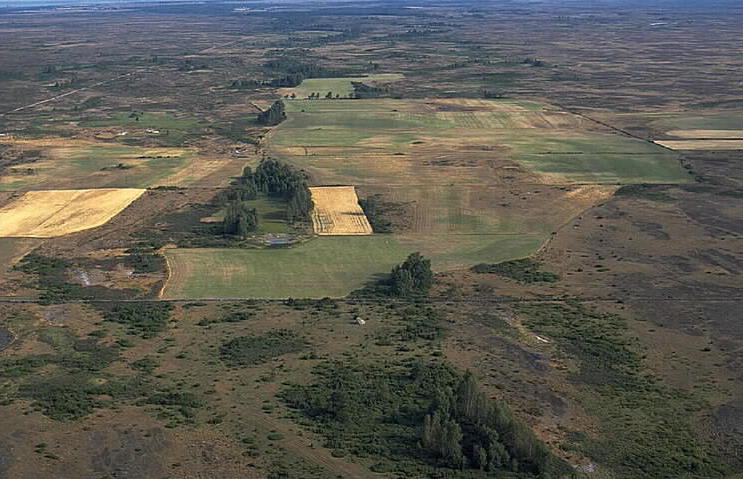
Notera Av dokumentationsskäl har originalbeskrivningen från Riksantikvarieämbetet behållits. Tillrättalägganden och alternativa beskrivningar bör införas separat från nedanstående information. Fornlämningsområde på Alvaret. Stensättning, husgrund och fyra resta stenar.Felaktigheter kan även anmälas till denna sida. Motiv: Storåshallen |
||||||||||||||||||||||||||
| Description |
Fornlämningsområde på Alvaret. Stensättning, husgrund och fyra resta stenar.
|
||||||||||||||||||||||||||
| Depicted place | Sweden, Mörbylånga Municipality, Q10688956 | ||||||||||||||||||||||||||
| Date | 26 July 1992 | ||||||||||||||||||||||||||
| Collection |
|
||||||||||||||||||||||||||
| Accession number | |||||||||||||||||||||||||||
| Source |
Jan Norrman / Kulturmiljöbild, Riksantikvarieämbetet
|
||||||||||||||||||||||||||
| Permission (Reusing this file) |
This file is licensed under the Creative Commons Attribution 2.5 Generic license. Attribution: Jan Norrman / Riksantikvarieämbetet
|
||||||||||||||||||||||||||


| Object location | | View this and other nearby images on: OpenStreetMap |
|---|
File history
Click on a date/time to view the file as it appeared at that time.
| Date/Time | Thumbnail | Dimensions | User | Comment | |
|---|---|---|---|---|---|
| current | 20:00, 16 November 2020 | | 743 × 479 (70 KB) | Nasko (talk | contribs) | Cropped 3 % horizontally, 6 % vertically using CropTool with lossless mode. |
| 14:12, 11 July 2017 |  | 768 × 512 (74 KB) | AndreCostaWMSE-bot (talk | contribs) | {{Kulturmiljöbild-image | short title = Storåshallen | original description = Fornlämningsområde på Alvaret. Stensättning, husgrund och fyra resta stenar.<br> Motiv: Storåshallen<br> Nyckelord: Flygbilder, Riksintressen, Världsarv<br> Kategori:... |
You cannot overwrite this file.
File usage on Commons
The following 4 pages use this file:
File usage on other wikis
The following other wikis use this file:
- Usage on sv.wikipedia.org
- Usage on www.wikidata.org