File:Stone Plan.jpg

Original file (4,016 × 4,252 pixels, file size: 1.91 MB, MIME type: image/jpeg)
Captions
Captions
Summary
[edit]
Druidic Calendar
| Description |
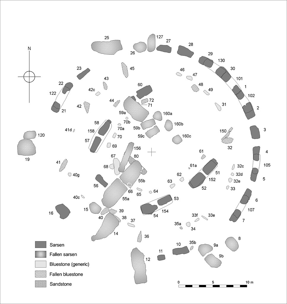
English: Plan of the central Stone Structure at Stonehenge as it survives today. Stone numbers are those conventionally used in the recent literature and following Petrie, F. 1880.
Note that the Term 'Sarsen' used on the key refers to the hard silicified tertiary rock local to the chalkland of the Stonehenge region, sarsen is an exceptionally obdurate form of sandstone: The reference to sandstone on the key is to other ‘non sarsen’ material. The term ‘bluestone’ conveniently, though somewhat controversially, describes a generic group of igneous rock exotic to Salisbury Plain. The major group of bluestones visible today are dolerite - whose province is regarded as south west Wales. A number of other igneous rocks are represented within the arrays. Those interested in the exact make up of the blustone assemblage are referred to Cleal 1995, and Cunliffe and Renfrew 1997. Cleal, R. M. J., Walker, K. E. & Montague, R., Stonehenge in its landscape (English Heritage, London, 1995) Cunliffe, B. & Renfrew, C. Science and Stonhenge (Proceedings of the British Academy - 92, Oxford University Press 1997) Johnson, A. Solving Stonehenge (Thames & Hudson 2008) |
| Date | |
| Source | Drawn by Author , a computer compilation of data from various surveys. |
| Author | Anthony Johnson |
| Permission (Reusing this file) |
By Author ©Anthony Johnson 2008 |
Licensing
[edit]

|
Permission is granted to copy, distribute and/or modify this document under the terms of the GNU Free Documentation License, Version 1.2 or any later version published by the Free Software Foundation; with no Invariant Sections, no Front-Cover Texts, and no Back-Cover Texts. A copy of the license is included in the section entitled GNU Free Documentation License. |
- You are free:
- to share – to copy, distribute and transmit the work
- to remix – to adapt the work
- Under the following conditions:
- attribution – You must give appropriate credit, provide a link to the license, and indicate if changes were made. You may do so in any reasonable manner, but not in any way that suggests the licensor endorses you or your use.
File history
Click on a date/time to view the file as it appeared at that time.
| Date/Time | Thumbnail | Dimensions | User | Comment | |
|---|---|---|---|---|---|
| current | 14:04, 27 September 2008 | | 4,016 × 4,252 (1.91 MB) | Sitehut~commonswiki (talk | contribs) | {{Information |Description={{en|1=Plan of the central stone structure at Stonehenge as it survives today. Conventional stone numbers shown. A eversion of the plan reproduced in 'Solving Stonehenge' (Thames & Hudson 2008).}} |Source=Drawn by Author , a com |
You cannot overwrite this file.
File usage on Commons
There are no pages that use this file.
File usage on other wikis
The following other wikis use this file:
- Usage on as.wikipedia.org
- Usage on de.wikipedia.org
- Usage on en.wikipedia.org
- Usage on es.wikipedia.org
- Usage on frr.wikipedia.org
- Usage on fr.wikipedia.org
- Usage on fy.wikipedia.org
- Usage on gl.wikipedia.org
- Usage on hr.wikipedia.org
- Usage on kw.wikipedia.org
- Usage on mt.wikipedia.org
- Usage on nl.wikipedia.org
- Usage on scn.wikipedia.org
- Usage on sr.wikipedia.org
- Usage on vi.wikipedia.org