File:State Department map of Gouta chemical attack.svg
Jump to navigation
Jump to search

Size of this PNG preview of this SVG file: 800 × 524 pixels. Other resolutions: 320 × 209 pixels | 640 × 419 pixels | 1,024 × 670 pixels | 1,280 × 838 pixels | 2,560 × 1,675 pixels | 978 × 640 pixels.
Original file (SVG file, nominally 978 × 640 pixels, file size: 622 KB)
Captions
Captions
Add a one-line explanation of what this file represents
Summary[edit]
| Description |
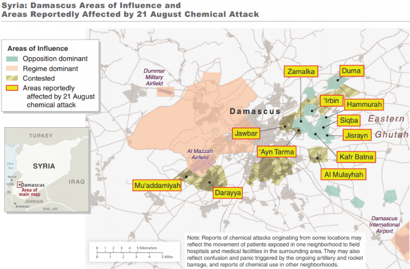
English: map of Gouta chemical attack |
| Date | |
| Source | http://www.whitehouse.gov/sites/default/files/docs/2013-08-30_map_accompanying_usg_assessment_on_syria.pdf |
| Author | White House Press Office |
Licensing[edit]
This work is in the public domain in the United States because it is a work prepared by an officer or employee of the United States Government as part of that person’s official duties under the terms of Title 17, Chapter 1, Section 105 of the US Code.
Note: This only applies to original works of the Federal Government and not to the work of any individual U.S. state, territory, commonwealth, county, municipality, or any other subdivision. This template also does not apply to postage stamp designs published by the United States Postal Service since 1978. (See § 313.6(C)(1) of Compendium of U.S. Copyright Office Practices). It also does not apply to certain US coins; see The US Mint Terms of Use.
|
 | |
| This file has been identified as being free of known restrictions under copyright law, including all related and neighboring rights. | ||

|
This image has been assessed under the valued image criteria and is considered the most valued image on Commons within the scope: Maps of the Ghouta chemical attack. You can see its nomination here. |
File history
Click on a date/time to view the file as it appeared at that time.
| Date/Time | Thumbnail | Dimensions | User | Comment | |
|---|---|---|---|---|---|
| current | 22:38, 30 August 2013 | | 978 × 640 (622 KB) | FutureTrillionaire (talk | contribs) | This version is less buggy |
| 22:35, 30 August 2013 |  | 730 × 480 (1.26 MB) | FutureTrillionaire (talk | contribs) | User created page with UploadWizard |
You cannot overwrite this file.
File usage on Commons
The following 4 pages use this file:
File usage on other wikis
The following other wikis use this file:
- Usage on ar.wikipedia.org
- Usage on ast.wikipedia.org
- Usage on de.wikipedia.org
- Usage on en.wikinews.org
- Usage on es.wikipedia.org
- Usage on es.wikinews.org
- Usage on hu.wikipedia.org
- Usage on pl.wikipedia.org
- Usage on pt.wikipedia.org
- Usage on ru.wikipedia.org
- Usage on ru.wikinews.org
- Usage on www.wikidata.org
- Usage on zh.wikipedia.org