File:Stag Lane cement works.jpg
Jump to navigation
Jump to search
No higher resolution available.
Stag_Lane_cement_works.jpg (640 × 480 pixels, file size: 136 KB, MIME type: image/jpeg)
Captions
Captions
Add a one-line explanation of what this file represents
Summary
[edit]
| Description |
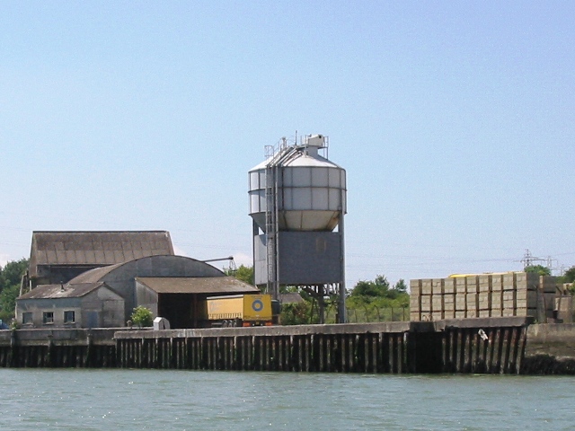
English: West Medina Cement Mill near to Parkhurst, Isle of Wight, England.
Originally a cement mill from 1852 until its closure in 1932 on the Western bank of the River Medina. Then used as a depot for cement "imported" from the mainland but currently under development, the first stage to include an Industrial Park on part of the site. |
| Date | |
| Source | see below |
| Author | see below |
| Camera location | | View this and other nearby images on: OpenStreetMap |
|---|
_heading:270.00&language=en)
| Object location | | View this and other nearby images on: OpenStreetMap |
|---|
_heading:270.00&language=en)
Licensing
[edit]

|
This image was taken from the Geograph project collection. See this photograph's page on the Geograph website for the photographer's contact details. The copyright on this image is owned by Mark Pilbeam and is licensed for reuse under the Creative Commons Attribution-ShareAlike 2.0 license.
|
This file is licensed under the Creative Commons Attribution-Share Alike 2.0 Generic license.
Attribution: Mark Pilbeam
- You are free:
- to share – to copy, distribute and transmit the work
- to remix – to adapt the work
- Under the following conditions:
- attribution – You must give appropriate credit, provide a link to the license, and indicate if changes were made. You may do so in any reasonable manner, but not in any way that suggests the licensor endorses you or your use.
- share alike – If you remix, transform, or build upon the material, you must distribute your contributions under the same or compatible license as the original.
Original upload log
[edit]
The original description page was here. All following user names refer to en.wikipedia.
- 2007-10-24 14:40 Bashereyre 640×480×8 (138921 bytes) Photo taken by Mark Pilbeam on 12th June 2007 and released onto Photograph every Grid Square via "Creative Commons" on that day.
File history
Click on a date/time to view the file as it appeared at that time.
| Date/Time | Thumbnail | Dimensions | User | Comment | |
|---|---|---|---|---|---|
| current | 19:43, 22 February 2008 | | 640 × 480 (136 KB) | File Upload Bot (Magnus Manske) (talk | contribs) | {{BotMoveToCommons|en.wikipedia}} {{Information |Description={{en|Photo taken by Mark Pilbeam on 12th June 2007 and released onto Photograph every Grid Square via "Creative Commons" on that day.}} |Source=Transferred from [http://en.wikipedia.org en.wiki |
You cannot overwrite this file.
File usage on Commons
There are no pages that use this file.
File usage on other wikis
The following other wikis use this file:
- Usage on en.wikipedia.org
- Usage on www.wikidata.org