File:St Stephens U Meth MH jeh.JPG
Jump to navigation
Jump to search

Size of this preview: 542 × 599 pixels. Other resolutions: 217 × 240 pixels | 434 × 480 pixels | 694 × 768 pixels | 926 × 1,024 pixels | 1,852 × 2,048 pixels | 2,912 × 3,220 pixels.
Original file (2,912 × 3,220 pixels, file size: 1.43 MB, MIME type: image/jpeg)
Captions
Captions
Add a one-line explanation of what this file represents
|
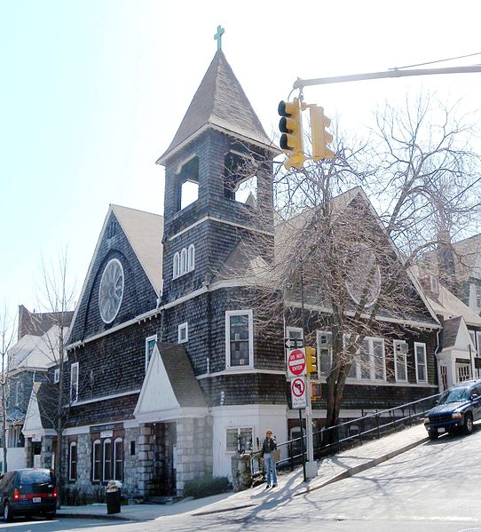
This is an image of a place or building that is listed on the National Register of Historic Places in the United States of America. Its reference number is 12000008. |
Summary[edit]
| Description | Looking south across 228th Street and Marble Hill Avenue on a sunny midday at St Stephens United Methodist Church in Marble Hill. |
| Date | |
| Source | Own work |
| Author | MyName (Jim.henderson (talk)) |
| Camera location | | View this and other nearby images on: OpenStreetMap |
|---|
Licensing[edit]
| I, the copyright holder of this work, release this work into the public domain. This applies worldwide. In some countries this may not be legally possible; if so: I grant anyone the right to use this work for any purpose, without any conditions, unless such conditions are required by law. |
File history
Click on a date/time to view the file as it appeared at that time.
| Date/Time | Thumbnail | Dimensions | User | Comment | |
|---|---|---|---|---|---|
| current | 03:15, 30 May 2014 | | 2,912 × 3,220 (1.43 MB) | Beyond My Ken (talk | contribs) | Slight crop in, adjustments to visibility |
| 17:18, 17 April 2009 |  | 3,377 × 3,371 (904 KB) | Jim.henderson (talk | contribs) | {{Information |Description= Looking north on a sunny midday at St Stephens United Methodist Church in Marble Hill. |Source=self-made |Date= 2009-04-02 |Author= MyName (~~~) |other_versions= }} Category:Marble Hill, New York City [[Category:Churche |
You cannot overwrite this file.
File usage on Commons
The following page uses this file:
File usage on other wikis
The following other wikis use this file:
- Usage on en.wikipedia.org
- Usage on es.wikipedia.org
- Usage on et.wikipedia.org
- Usage on fr.wikipedia.org
- Usage on nl.wikipedia.org
- Usage on pt.wikipedia.org
- Usage on www.wikidata.org