File:St Paul's United Methodist Church from Binz.jpg

Original file (3,144 × 2,348 pixels, file size: 2.41 MB, MIME type: image/jpeg)
Captions
Captions
Summary[edit]
| Description |
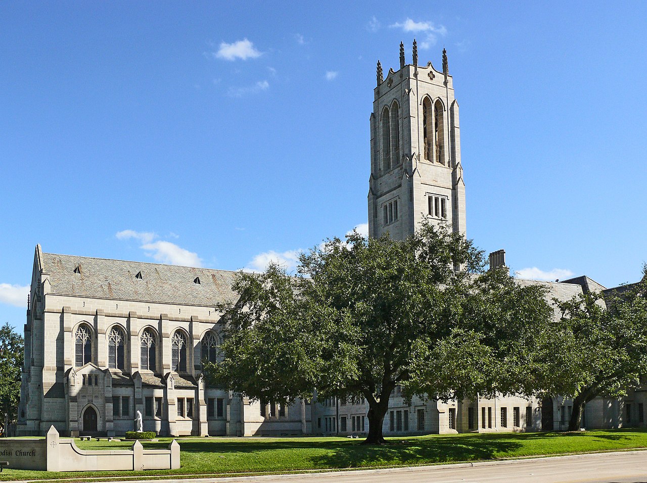
English: At the beginning of the 20th century, members of Houston’s Methodist community worked toward organizing a new congregation on what was then the burgeoning south end of town. In December 1905, individuals met at the J.O. Ross family home and held Christmas Eve services at the city auditorium. The congregation officially organized on January 14, 1906 with 153 charter members. Bishop Joseph Key preached the first sermon and suggested the congregation adopt St. Paul’s as its name. The Ross family gave lots at the corner of Milam and McGowen streets for a new building. Designed by R.D. Steele and consecrated in January 1909. The structure reflected a Grecian design with a dome reminiscent of Byzantine architecture.
The church grew along with the city of Houston, and in the late 1920s, members launched a campaign to raise money for new facilities. Jesse H. Jones, Walter Fondren and J.M. West, Sr. each contributed $150,000, and the church hired noted architect Alfred C. Finn to design a new building at the corner of Main and Binz streets. The Neo-Gothic styling features a cruciform plan on a steel-frame structure with limestone cladding. Stained glass windows from the structure, and the impressive tower houses bells also brought from the church’s original sanctuary. St. Paul’s church members support an array of outreach, worship, education, mission, music and caring services to the community. At the turn of the 21st century, the church is a spiritual and social community center, as well as a long-standing Houston institution. Coordinates N29° 43.576 W95° 23.336 |
| Date | |
| Source | Own work |
| Author | i_am_jim |
| Camera location | | View this and other nearby images on: OpenStreetMap |
|---|
Licensing[edit]
- You are free:
- to share – to copy, distribute and transmit the work
- to remix – to adapt the work
- Under the following conditions:
- attribution – You must give appropriate credit, provide a link to the license, and indicate if changes were made. You may do so in any reasonable manner, but not in any way that suggests the licensor endorses you or your use.
- share alike – If you remix, transform, or build upon the material, you must distribute your contributions under the same or compatible license as the original.

|
This image has been assessed under the valued image criteria and is considered the most valued image on Commons within the scope: St. Paul's United Methodist Church (Houston). You can see its nomination here. |
File history
Click on a date/time to view the file as it appeared at that time.
| Date/Time | Thumbnail | Dimensions | User | Comment | |
|---|---|---|---|---|---|
| current | 23:13, 5 March 2019 | | 3,144 × 2,348 (2.41 MB) | Jim Evans (talk | contribs) | larger image |
| 16:35, 11 November 2012 |  | 2,000 × 1,494 (1.28 MB) | Wiki name~commonswiki (talk | contribs) | User created page with UploadWizard |
You cannot overwrite this file.
File usage on Commons
The following 5 pages use this file:
File usage on other wikis
The following other wikis use this file:
- Usage on en.wikipedia.org
- Usage on www.wikidata.org