File:St Lucia Estuary ISS006-E-38182.jpg
Jump to navigation
Jump to search

Size of this preview: 800 × 529 pixels. Other resolutions: 320 × 212 pixels | 640 × 423 pixels | 1,024 × 677 pixels | 1,280 × 847 pixels | 3,032 × 2,006 pixels.
Original file (3,032 × 2,006 pixels, file size: 1.08 MB, MIME type: image/jpeg)
Captions
Captions
Add a one-line explanation of what this file represents
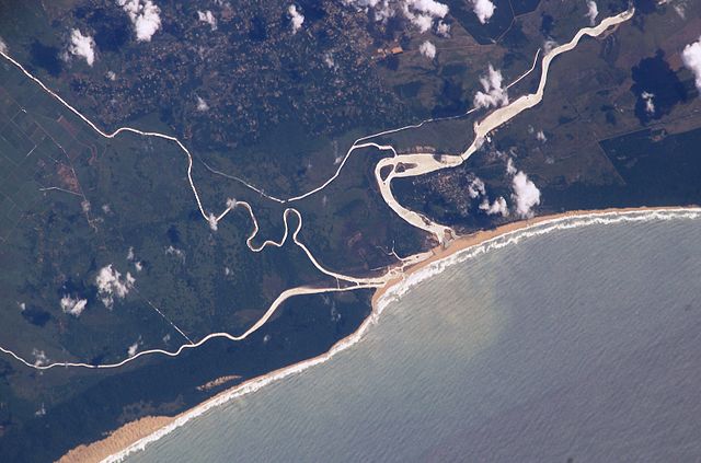
| Description | Saint Lucia Estuary, seen from space, image #ISS006-E-38182. The Msunduzi River is seen on the left (south), the Umfolozi in the middle, with canals since abandoned, and the St. Lucia estuary on the right (north). St. Lucia town is visible inside the bend of the estuary. Between the Msunduzi and Umfolozi is a wetland, showing as a mottled area. On the far left are sugar cane fields. Note a silt plume in the sea. |
| Date | |
| Source | [1] |
| Author | NASA |
This image or video was catalogued by one of the centers of the United States National Aeronautics and Space Administration (NASA) under Photo ID: ISS006-E-38182. This tag does not indicate the copyright status of the attached work. A normal copyright tag is still required. See Commons:Licensing. Other languages:
|
| This file is in the public domain in the United States because it was solely created by NASA. NASA copyright policy states that "NASA material is not protected by copyright unless noted". (See Template:PD-USGov, NASA copyright policy page or JPL Image Use Policy.) | ||
 |
Warnings:
|
File history
Click on a date/time to view the file as it appeared at that time.
| Date/Time | Thumbnail | Dimensions | User | Comment | |
|---|---|---|---|---|---|
| current | 15:56, 4 November 2005 | | 3,032 × 2,006 (1.08 MB) | Tintazul (talk | contribs) | {{Information| |Description=Saint Lucia Estuary, seen from space. Image #ISS006-E-38182 |Source=[http://eol.jsc.nasa.gov/scripts/sseop/photo.pl?mission=ISS006&roll=E&frame=38182] |Date=14 March 2003 |Author=Júlio Reis (User:Tintazul) |Permission=This |
You cannot overwrite this file.
File usage on Commons
The following 3 pages use this file:
File usage on other wikis
The following other wikis use this file:
- Usage on ast.wikipedia.org
- Usage on de.wikipedia.org
- Usage on en.wikipedia.org
- Usage on es.wikipedia.org
- Usage on fr.wikipedia.org
- Usage on hr.wikipedia.org
- Usage on is.wikipedia.org
- Usage on ja.wikipedia.org
- Usage on ko.wikipedia.org
- Usage on pt.wikipedia.org
- Usage on sh.wikipedia.org
- Usage on sv.wikipedia.org
- Usage on sw.wikipedia.org
- Usage on www.wikidata.org
Metadata
Categories:
- ISimangaliso Wetland Park
- Rivers of South Africa
- Satellite pictures of rivers
- Satellite pictures of South Africa
- Estuaries of South Africa
- ISS Expedition 6 Crew Earth Observations
- Geomorphology of South Africa
- Umfolozi River
- River mouths in South Africa
- Silt in South Africa
- Coastal sediment transport
- Fluvial sediment transport in South Africa
- Marine sediment transport