File:St Gregory Pottergate, Norwich - C18 monument - geograph.org.uk - 2102921.jpg

Original file (480 × 640 pixels, file size: 116 KB, MIME type: image/jpeg)
Captions
Captions
| Description |
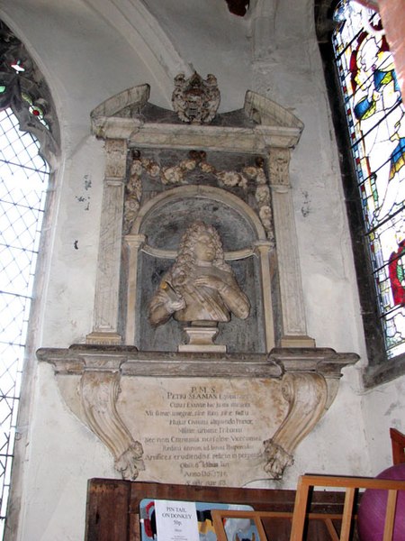
St Gregory's Church, Pottergate, Norwich, mural monument, east end of north aisle, to Sir Peter Seaman (1662-1715), Knight Batchelor, brewer, Mayor of Norwich 1707-8, Colonel of the City Corps and w:High Sheriff of Norfolk in 1710. Arms: Barry wavy of six argent and azure (Seaman) (canting arms, representing "the sea") T. Green, fecit. " P.M.S. Petri Seaman, Equitis Aurati, cuius exuviae hic juxta sitae sunt . . . . ob. vi. Iduum Jan., An. Dm. 1715, aetatis suae 53." (Source: Farrer, Edmund, Church Heraldry of Norfolk, Vol 3 (1893) Lynn, Norwich, Thetford, Yarmouth, p.62 [1]) Text per: /www.norwich-heritage.co.uk [2]
Sir Peter Seaman’s Charity (Registered Charity No 311101) arises from the will of Sir Peter Seaman who died in 1715. The Charity is governed by a Scheme of the Charity Commission dated 19th November 1889 as varied be Schemes of the Charity Commission dated 6th January 1931 and 15th March 1932. Charity Objective: The principal objective of the charity is to provide grants for the promotion of education, including social and physical training, of young persons of the City of Norwich who are under the age of 21 and who, in the opinion of the Trustees, are in need of financial assistance. Grants are made in accordance with the Scheme and within the financial resources of the Charity. The objective of the Charity is to apply the cleared income of the trust fund to provide grants for the promotion of education, including social and physical training, of persons under the age of 21 as the Trustees in their discretion may from time to time determine. The area of benefit is the City of Norwich and the contiguous parishes of Old Catton, Sprowston, Thorpe St. Andrew, Trowse with Newton, Cringleford, Colney, Costessey, Taverham, Drayton, Hellesdon and Horsham and Newton St. Faiths. (www.greathospital.org.uk [4]) Text from BlomefieldFrancis Blomefield, 'City of Norwich, chapter 42: West Wimer ward', in An Essay Towards A Topographical History of the County of Norfolk: Volume 4, the History of the City and County of Norwich, Part II (London, 1806), pp. 247-287 [5]
|
| Date |
|
| Source |
Geograph Britain and Ireland |
| Author |
Evelyn Simak |
![[3]](http://www.norwich-heritage.co.uk/monuments/Peter%20Seaman/images/Peter-Seaman-words.jpg)
Summary
| Description |
English: St Gregory Pottergate, Norwich - C18 monument |
| Depicts | church interior, Norwich |
| Date |
|
| Source |
Geograph Britain and Ireland |
| Author |
Evelyn Simak |
| Place of creation | Norwich |
| Camera location | | View this and other nearby images on: OpenStreetMap |
|---|
| Object location | | View this and other nearby images on: OpenStreetMap |
|---|
Licensing

|
This image was taken from the Geograph project collection. See this photograph's page on the Geograph website for the photographer's contact details. The copyright on this image is owned by Evelyn Simak
|
- You are free:
- to share – to copy, distribute and transmit the work
- to remix – to adapt the work
- Under the following conditions:
- attribution – You must give appropriate credit, provide a link to the license, and indicate if changes were made. You may do so in any reasonable manner, but not in any way that suggests the licensor endorses you or your use.
- share alike – If you remix, transform, or build upon the material, you must distribute your contributions under the same or compatible license as the original.
File history
Click on a date/time to view the file as it appeared at that time.
| Date/Time | Thumbnail | Dimensions | User | Comment | |
|---|---|---|---|---|---|
| current | 19:32, 2 June 2021 | | 480 × 640 (116 KB) | GeographBot (talk | contribs) | Uploading geograph.org.uk image from https://www.geograph.org.uk/photo/2102921 |
You cannot overwrite this file.
File usage on Commons
There are no pages that use this file.
File usage on other wikis
The following other wikis use this file:
- Usage on en.wikipedia.org
- Usage on www.wikidata.org