File:Ssxiso.gif
Jump to navigation
Jump to search

Size of this preview: 800 × 522 pixels. Other resolutions: 320 × 209 pixels | 640 × 418 pixels | 924 × 603 pixels.
Original file (924 × 603 pixels, file size: 39 KB, MIME type: image/gif)
Captions
Captions
Add a one-line explanation of what this file represents
Summary[edit]
| Description |
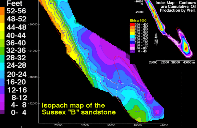
English: Isopach map of the Sussex "B" sandstone showing thickness in feet of the interval between bounding disconformities; contour interval is 4 ft (1.2 m). Map scales are meters. The small index contour map is cumulative oil production; contour interval is 40,000 barrels. The thin red line outlines the boundary of the House Creek field. Thin white lines in the southern half of the field are limits of sand-ridge 1 and overlying sand-ridge 2.
|
|||
| Source | http://pubs.usgs.gov/dds/dds-033/USGS_3D/ssx_gif/ssxiso.gif | |||
| Author | USGS |
Licensing[edit]
This image is in the public domain in the United States because it only contains materials that originally came from the United States Geological Survey, an agency of the United States Department of the Interior. For more information, see the official USGS copyright policy.
|
File history
Click on a date/time to view the file as it appeared at that time.
| Date/Time | Thumbnail | Dimensions | User | Comment | |
|---|---|---|---|---|---|
| current | 04:51, 14 July 2008 | | 924 × 603 (39 KB) | דקי (talk | contribs) | {{Information |Description={{en|1=Isopach map of the Sussex "B" sandstone showing thickness in feet of the interval between bounding disconformities; contour interval is 4 ft (1.2 m). Map scales are meters. The small index contour map is cumulative oil pr |
You cannot overwrite this file.
File usage on Commons
There are no pages that use this file.
File usage on other wikis
The following other wikis use this file:
- Usage on he.wikipedia.org