File:Squared Chart as used by 255 Squadron in 1918..png
Jump to navigation
Jump to search
Size of this preview: 381 × 600 pixels. Other resolutions: 152 × 240 pixels | 305 × 480 pixels | 488 × 768 pixels | 1,258 × 1,980 pixels.
Original file (1,258 × 1,980 pixels, file size: 4.01 MB, MIME type: image/png)
Captions
Captions
Add a one-line explanation of what this file represents
Summary[edit]
| Description |
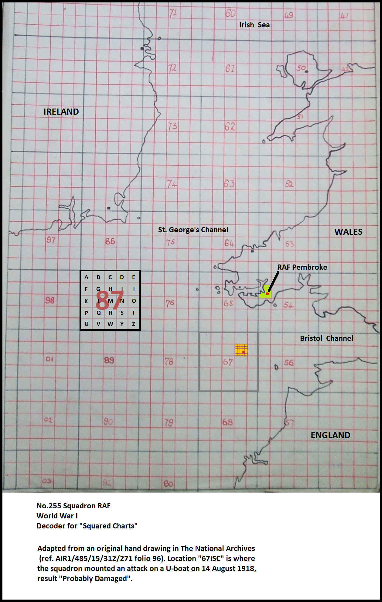
English: The system of "Squared Charts" was used to simplify the reporting of Latitude/Longitude. Crown copyright on the original chart has expired and written consent for this modified image to be presented as the uploader's own work has been obtained from The National Archives of the United Kingdom. (E-mail, Hugh Alexander, Deputy Manager of TNA Image Library, to Chris Eley on 25 Sep 2014 at 12:38.) |
| Date | |
| Source | Own work |
| Author | Christopher Michael ELEY on behalf of 255 Squadron Association, RAF |
At the time this chart was in use, No.255 Squadron was based at RAF Pembroke.
Licensing[edit]
I, the copyright holder of this work, hereby publish it under the following license:
This file is licensed under the Creative Commons Attribution-Share Alike 4.0 International license.
- You are free:
- to share – to copy, distribute and transmit the work
- to remix – to adapt the work
- Under the following conditions:
- attribution – You must give appropriate credit, provide a link to the license, and indicate if changes were made. You may do so in any reasonable manner, but not in any way that suggests the licensor endorses you or your use.
- share alike – If you remix, transform, or build upon the material, you must distribute your contributions under the same or compatible license as the original.
File history
Click on a date/time to view the file as it appeared at that time.
| Date/Time | Thumbnail | Dimensions | User | Comment | |
|---|---|---|---|---|---|
| current | 16:57, 26 September 2014 | | 1,258 × 1,980 (4.01 MB) | 255 Squadron Association (talk | contribs) | User created page with UploadWizard |
You cannot overwrite this file.
File usage on Commons
There are no pages that use this file.