File:Spratly Islands (US State Department) 2015.jpg
Jump to navigation
Jump to search
Size of this preview: 793 × 600 pixels. Other resolutions: 317 × 240 pixels | 635 × 480 pixels | 1,015 × 768 pixels | 1,280 × 968 pixels | 2,560 × 1,937 pixels | 5,340 × 4,040 pixels.
Original file (5,340 × 4,040 pixels, file size: 5.23 MB, MIME type: image/jpeg)
Captions
Captions
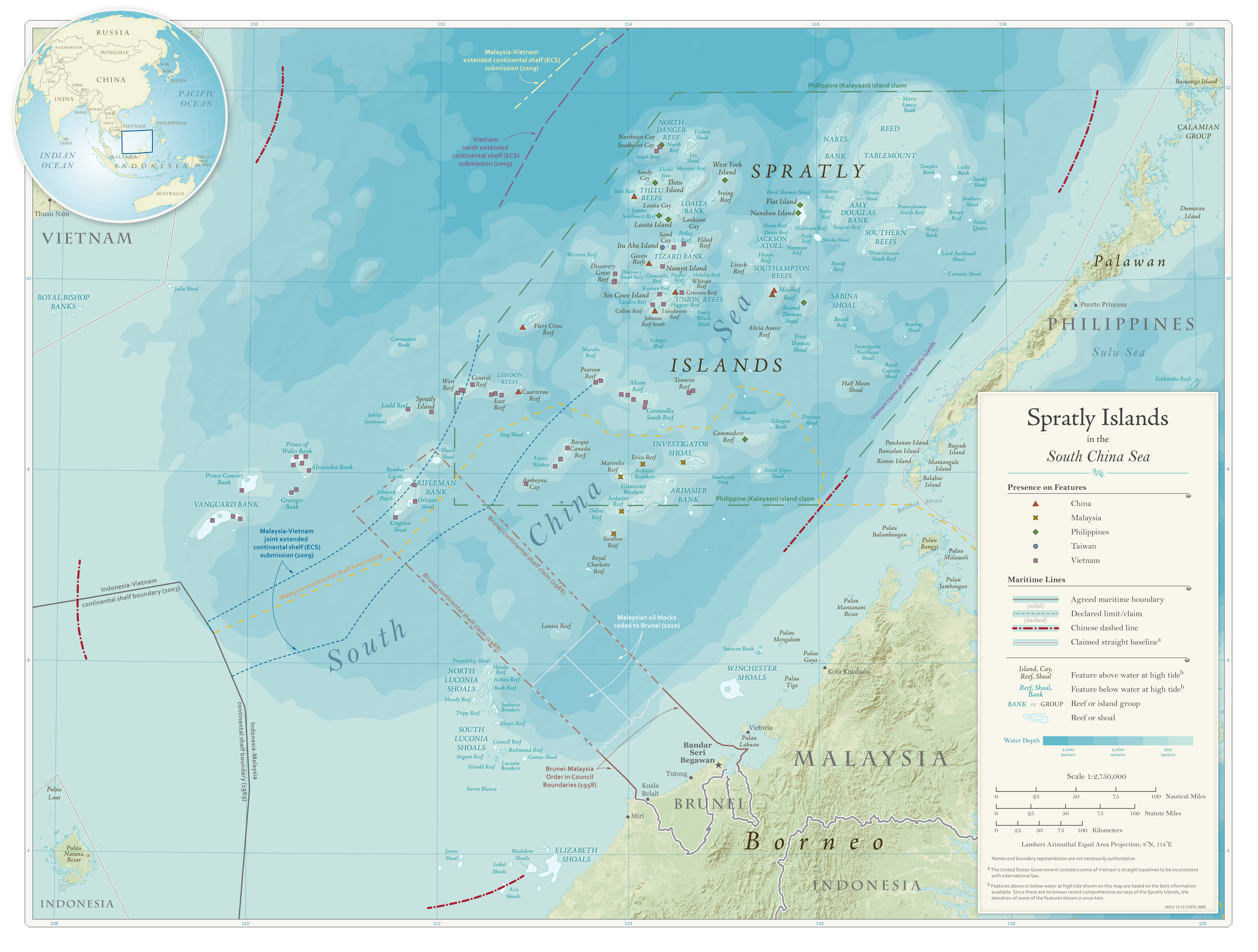
Status of features in the Spratly Islands as of 2015
Summary[edit]
_2015.jpg&action=edit§ion=1)
| Description |
English: This 2015 map from the United States Department of State shows which country had been present on which features in the Spratly Islands and markings for certain zones. |
| Date | |
| Source | United States Department of State Bureau of Intelligence and Research |
| Author | United States Department of State Bureau of Intelligence and Research |
Licensing[edit]
_2015.jpg&action=edit§ion=2)
This work is in the public domain in the United States because it is a work prepared by an officer or employee of the United States Government as part of that person’s official duties under the terms of Title 17, Chapter 1, Section 105 of the US Code.
Note: This only applies to original works of the Federal Government and not to the work of any individual U.S. state, territory, commonwealth, county, municipality, or any other subdivision. This template also does not apply to postage stamp designs published by the United States Postal Service since 1978. (See § 313.6(C)(1) of Compendium of U.S. Copyright Office Practices). It also does not apply to certain US coins; see The US Mint Terms of Use.
|
 | |
| This file has been identified as being free of known restrictions under copyright law, including all related and neighboring rights. | ||
File history
Click on a date/time to view the file as it appeared at that time.
| Date/Time | Thumbnail | Dimensions | User | Comment | |
|---|---|---|---|---|---|
| current | 20:14, 31 October 2023 | | 5,340 × 4,040 (5.23 MB) | Candivore (talk | contribs) | Uploaded a work by United States Department of State Bureau of Intelligence and Research from United States Department of State Bureau of Intelligence and Research with UploadWizard |
You cannot overwrite this file.
File usage on Commons
There are no pages that use this file.
_2015.jpg&oldid=870390140)