File:Sperrzonen Sprengung AfE-Turm 02.02.2014.png

Original file (822 × 822 pixels, file size: 494 KB, MIME type: image/png)
Captions
Captions
Summary[edit]
| DescriptionSperrzonen Sprengung AfE-Turm 02.02.2014.png |
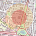
Deutsch: Ausschnitt OpenStreetMap-Karte des AfE-Turms in Frankfurt am Main.
Geplante Sprengung am 02.02.2014 um 10:00 MEZ. Roter Kreis: 135m-Sperrzone (ab 8:00 MEZ kein Aufenthalt von Personen mehr) Orangefarbener Kreis: 250m-Sperrzone (ab 9:30 MEZ Aufenthalt von Personen nur in Gebäuden) Alle Angaben ohne Gewähr.English: OpenStreetMap extract of AfE-Turm, Frankfurt, Germany.
Scheduled blasting at 2014-02-02, 10:00 CET. Red circle: 135m danger zone (no stay of persons from 8:00 CET) Orange circle: 250m danger zone (stay of persons in buildings only from 9:30 CET) No responsiblity is taken for the correctness of this information. |
| Date | |
| Source | http://www.openstreetmap.org/copyright and Layer-Plugin http://wp-osm-plugin.hanblog.net/ |
| Author | Sandres |
| Camera location | 50° 06′ 57.92″ N, 8° 39′ 04.68″ E | View this and other nearby images on: OpenStreetMap |
|---|
Licensing[edit]
- You are free:
- to share – to copy, distribute and transmit the work
- to remix – to adapt the work
- Under the following conditions:
- attribution – You must give appropriate credit, provide a link to the license, and indicate if changes were made. You may do so in any reasonable manner, but not in any way that suggests the licensor endorses you or your use.
- share alike – If you remix, transform, or build upon the material, you must distribute your contributions under the same or compatible license as the original.
File history
Click on a date/time to view the file as it appeared at that time.
| Date/Time | Thumbnail | Dimensions | User | Comment | |
|---|---|---|---|---|---|
| current | 00:36, 24 January 2014 |  | 822 × 822 (494 KB) | Sandres (talk | contribs) | Radien der Sperrzonen mit Hilfe von [http://sg.geodatenzentrum.de/web_bkg_webmap/applications/dop/dop_viewer.html DOP-Viewer] nachgemessen und interpoliert. Müsste nun korrekt sein. Radii checked with [http://sg.geodatenzentrum.de/web_bkg_webmap/appli... |
| 13:52, 23 January 2014 |  | 822 × 822 (494 KB) | Sandres (talk | contribs) | Sperrzonen manuell vergrößert, wie auch von GMaps dargestellt. Ohne Gewähr! Changed radius of danger zones manually, as shown by gmaps. No responsiblity is taken for the correctness of this information! | |
| 15:22, 22 January 2014 |  | 802 × 802 (464 KB) | Sandres (talk | contribs) | User created page with UploadWizard |
You cannot overwrite this file.
File usage on Commons
There are no pages that use this file.
File usage on other wikis
The following other wikis use this file:
- Usage on de.wikipedia.org
Metadata
This file contains additional information such as Exif metadata which may have been added by the digital camera, scanner, or software program used to create or digitize it. If the file has been modified from its original state, some details such as the timestamp may not fully reflect those of the original file. The timestamp is only as accurate as the clock in the camera, and it may be completely wrong.
| Horizontal resolution | 118.11 dpc |
|---|---|
| Vertical resolution | 118.11 dpc |
| File change date and time | 00:24, 24 January 2014 |