File:Spelga Dam - geograph.org.uk - 1205758.jpg
Spelga_Dam_-_geograph.org.uk_-_1205758.jpg (640 × 429 pixels, file size: 260 KB, MIME type: image/jpeg)
Captions
Captions
Summary
[edit]
| Description |
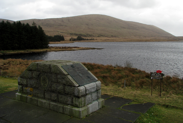
English: Spelga Dam. The Spelga Dam reservoir in the Mournes. See 1209131 and 1209120 for a few pictures from the little monument in the foreground.
There is a complete plaque on the monument which reads as thus: 1960 PORTADOWN AND BANBRIDGE REGIONAL WATERWORKS JOINT BOARD SPELGA DAM DURING THE YEAR 1946 THE PORTADOWN AND BANBRIDGE JOINT WATERWORKS BOARD INSTRUCTED THEIR CONSULTING ENGINEERS TO INVESTIGATE AND RECOMMEND AN ADDITIONAL SOURCE OF WATER TO SERVE THE INCREASED REQUIREMENTS OF THEIR AREA. THIS WORK CONTINUED WHEN THE ABOVE BOARD WAS ABSORBED INTO THE NEW AND ENLARGED PORTADOWN AND BANBRIDGE REGIONAL WATERWORKS JOINT BOARD IN 1948. THE NEW BOARD BEING COMPOSED OF THE FOLLOWING AUTHORITIES: PORTADOWN BOROUGH DISTRICT BANBRIDGE URBAN DISTRICT NEWRY URBAN DISTRICT DROMORE URBAN DISTRICT BANBRIDGE RURAL DISTRICT NEWRY No1 RURAL DISTRICT TANDRAGEE RURAL DISTRICT DOWNPATRICK RURAL DISTRICT VARIOUS SOURCES OF SUPPLY WERE INVESTIGATED AND ON THE RECOMMENDATION OF THE CONSULTING ENGINEERS THE BOARD DECIDED THAT A DAM SITUATED IN DEER'S MEADOW AT THE HEAD OF THE SPELGA PASS WOULD AUGMENT THEIR OTHER SOURCES SUFFICIENTLY TO SERVE THEIR REQUIREMENTS. INSTRUCTIONS WERE THEN GIVEN FOR A DESIGN TO BE PREPARED AND CONSTRUCTION COMMENCED IN NOVEMBER 1954. THE FIRST ROCK FOR THE FOUNDATIONS WAS EXCAVATED IN MAY 1955. PLACING OF CONCRETE COMMENCED DURING OCTOBER OF THAT YEAR. FILLING OF THE RESERVOIR BEGAN IN THE MONTH OF AUGUST 1957 AND THE WATER OVERFLOWED IN NOVEMBER OF THAT YEAR. SPELGA DAM, TOGETHER WITH FOFANNY RESERVOIR, IS CAPABLE OF SUPPLYING 6,500,000 GALLONS OF WATER PER DAY. 500,000 GALLONS ARE DISCHARGED INTO THE RIVER BANN AS COMPENSATION WATER AND THE REMAINDER AFTER FILTRATION IS USED TO SATISFY THE REQUIREMENTS OF THE COMPONENT AUTHORITIES AND THE KILCOO AREA OF KILKEEL RURAL DISTRICT. |
| Date | |
| Source | From geograph.org.uk |
| Author | Ross |
| Camera location | | View this and other nearby images on: OpenStreetMap |
|---|
_heading:135.00&language=en)
| Object location | | View this and other nearby images on: OpenStreetMap |
|---|
_heading:135.00&language=en)
Licensing
[edit]

|
This image was taken from the Geograph project collection. See this photograph's page on the Geograph website for the photographer's contact details. The copyright on this image is owned by Ross and is licensed for reuse under the Creative Commons Attribution-ShareAlike 2.0 license.
|
- You are free:
- to share – to copy, distribute and transmit the work
- to remix – to adapt the work
- Under the following conditions:
- attribution – You must give appropriate credit, provide a link to the license, and indicate if changes were made. You may do so in any reasonable manner, but not in any way that suggests the licensor endorses you or your use.
- share alike – If you remix, transform, or build upon the material, you must distribute your contributions under the same or compatible license as the original.
File history
Click on a date/time to view the file as it appeared at that time.
| Date/Time | Thumbnail | Dimensions | User | Comment | |
|---|---|---|---|---|---|
| current | 04:28, 26 February 2011 | | 640 × 429 (260 KB) | GeographBot (talk | contribs) | == {{int:filedesc}} == {{Information |description={{en|1=Spelga Dam The Spelga Dam reservoir in the Mournes. See 1209131 and 1209120 for a few pictures from the little monument in the foreground. There is a complete plaque on the monument which |
You cannot overwrite this file.
File usage on Commons
There are no pages that use this file.