File:Soco Gap-2014.jpg
Jump to navigation
Jump to search

Size of this preview: 800 × 534 pixels. Other resolutions: 320 × 214 pixels | 640 × 427 pixels | 1,024 × 683 pixels | 1,280 × 854 pixels | 2,560 × 1,709 pixels | 5,520 × 3,684 pixels.
Original file (5,520 × 3,684 pixels, file size: 8.23 MB, MIME type: image/jpeg)
Captions
Captions
Add a one-line explanation of what this file represents
Summary[edit]
| Description |
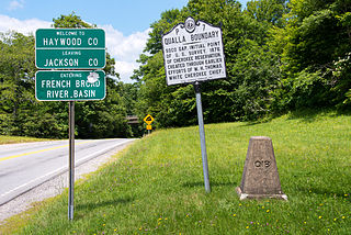
English: At the Soco Gap, located at the eastern point of the Qualla Boundary, between Haywood and Jackson counties, and connects both U.S. Route 19 and the Blue Ridge Parkway. |
| Date | |
| Source | Own work |
| Author | Washuotaku |
| Camera location | | View this and other nearby images on: OpenStreetMap |
|---|
Licensing[edit]
I, the copyright holder of this work, hereby publish it under the following license:
This file is licensed under the Creative Commons Attribution-Share Alike 4.0 International license.
- You are free:
- to share – to copy, distribute and transmit the work
- to remix – to adapt the work
- Under the following conditions:
- attribution – You must give appropriate credit, provide a link to the license, and indicate if changes were made. You may do so in any reasonable manner, but not in any way that suggests the licensor endorses you or your use.
- share alike – If you remix, transform, or build upon the material, you must distribute your contributions under the same or compatible license as the original.
File history
Click on a date/time to view the file as it appeared at that time.
| Date/Time | Thumbnail | Dimensions | User | Comment | |
|---|---|---|---|---|---|
| current | 02:23, 19 July 2014 | | 5,520 × 3,684 (8.23 MB) | Washuotaku (talk | contribs) | User created page with UploadWizard |
You cannot overwrite this file.
File usage on Commons
The following 8 pages use this file:
- Category:Births in Haywood County, North Carolina
- Category:Geography of Haywood County, North Carolina
- Category:Haywood County, North Carolina
- Category:Maps of Haywood County, North Carolina
- Category:People of Haywood County, North Carolina
- Category:Qualla Boundary
- Category:Qualla Boundary Historic Marker P-7
- Category:Soco Gap
File usage on other wikis
The following other wikis use this file:
- Usage on ce.wikipedia.org
- Usage on en.wikipedia.org
- Usage on tt.wikipedia.org
- Usage on www.wikidata.org
Metadata
Categories:
- Qualla Boundary
- Road signs in North Carolina
- Warning road signs in North Carolina
- Qualla Boundary Historic Marker P-7
- July 2014 in North Carolina
- Soco Gap
- County signs in North Carolina
- Signs in Haywood County, North Carolina
- Signs in Jackson County, North Carolina
- Drainage basins
- French Broad River
- River signs in the United States