File:Snow in the Southeastern United States (MODIS 2022-01-20).jpg
Jump to navigation
Jump to search
Size of this preview: 737 × 599 pixels. Other resolutions: 295 × 240 pixels | 590 × 480 pixels | 944 × 768 pixels | 1,259 × 1,024 pixels | 2,518 × 2,048 pixels | 3,760 × 3,058 pixels.
Original file (3,760 × 3,058 pixels, file size: 1.46 MB, MIME type: image/jpeg)
Captions
Captions
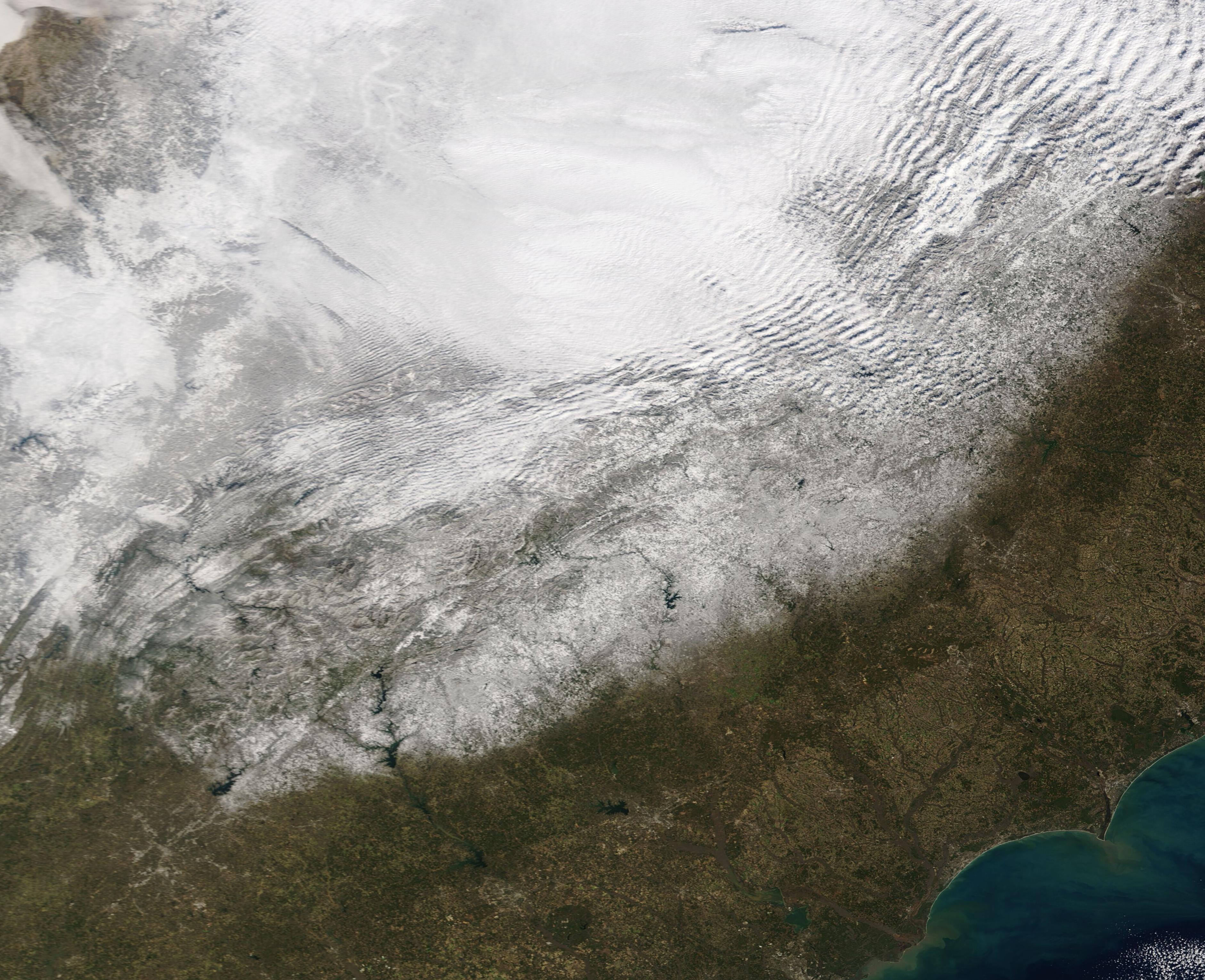
The Moderate Resolution Imaging Spectroradiometer (MODIS) on board NASA’s Terra satellite acquired a true-color image of a swath of snow painted by the robust winter storm.
Summary[edit]
.jpg&action=edit§ion=1)
| Description |
English: A strong “Saskatchewan Screamer” whipped up wicked weather across much of the United States in mid-January 2022, leaving a swath of snow and wind damage in its wake. The fast-moving low-pressure system developed over Saskatchewan, Canada then dropped below the border on January 13, bringing up to 12 inches of snow in northern North Dakota and western Minnesota. Des Moines, Iowa was buried under a whopping 14.3 inches of snow as the stormed screamed southward, bringing heavy snow to parts of Missouri, Arkansas, Tennessee—and tornadoes to Florida—before pivoting northeastward to roar across the Mid-Atlantic and Northeast. According to The Weather Channel, the heaviest snow totals from the January 13-17 storm fell in northeast Ohio, northwest Pennsylvania, and western New York. They report 27 inches of snow in Ashtabula, Ohio and 23.4 inches near Kenmore New York.
The Moderate Resolution Imaging Spectroradiometer (MODIS) on board NASA’s Terra satellite acquired a true-color image of a swath of snow painted by the robust winter storm. The band of visible snow is centered on the I-95 corridor, starting just north of Atlanta, Georgia and covered parts of Georgia, South Carolina, Tennessee, North Carolina and Virginia. Heavy cloud hangs over Kentucky, West Virginia, Ohio, and western Maryland. A “Saskatchewan Screamer” is a nickname for a fast-moving low-pressure system that sweeps southeast out of the Canadian province of Saskatchewan, typically carrying snow, strong winds, and cold air along with it. If a similar system develops to the west, over the province of Alberta, it is known as an Alberta Clipper. Move the origin to the east, and it can be called a Manitoba Mauler. |
||
| Date | Taken on 18 January 2022 | ||
| Source |
Snow in the Southeastern United States (direct link)
|
||
| Author | MODIS Land Rapid Response Team, NASA GSFC |
| This media is a product of the Terra mission Credit and attribution belongs to the mission team, if not already specified in the "author" row |
Licensing[edit]
.jpg&action=edit§ion=2)
| This file is in the public domain in the United States because it was solely created by NASA. NASA copyright policy states that "NASA material is not protected by copyright unless noted". (See Template:PD-USGov, NASA copyright policy page or JPL Image Use Policy.) | ||
 |
Warnings:
|
File history
Click on a date/time to view the file as it appeared at that time.
| Date/Time | Thumbnail | Dimensions | User | Comment | |
|---|---|---|---|---|---|
| current | 22:20, 9 January 2024 | | 3,760 × 3,058 (1.46 MB) | OptimusPrimeBot (talk | contribs) | #Spacemedia - Upload of http://modis.gsfc.nasa.gov/gallery/images/image01202022_250m.jpg via Commons:Spacemedia |
You cannot overwrite this file.
File usage on Commons
There are no pages that use this file.
.jpg&oldid=840280427)