File:Snow in Northeastern United States (MODIS 2021-03-01).jpg

Original file (4,261 × 3,387 pixels, file size: 2.2 MB, MIME type: image/jpeg)
Captions
Captions
Summary[edit]
.jpg&action=edit§ion=1)
| Description |
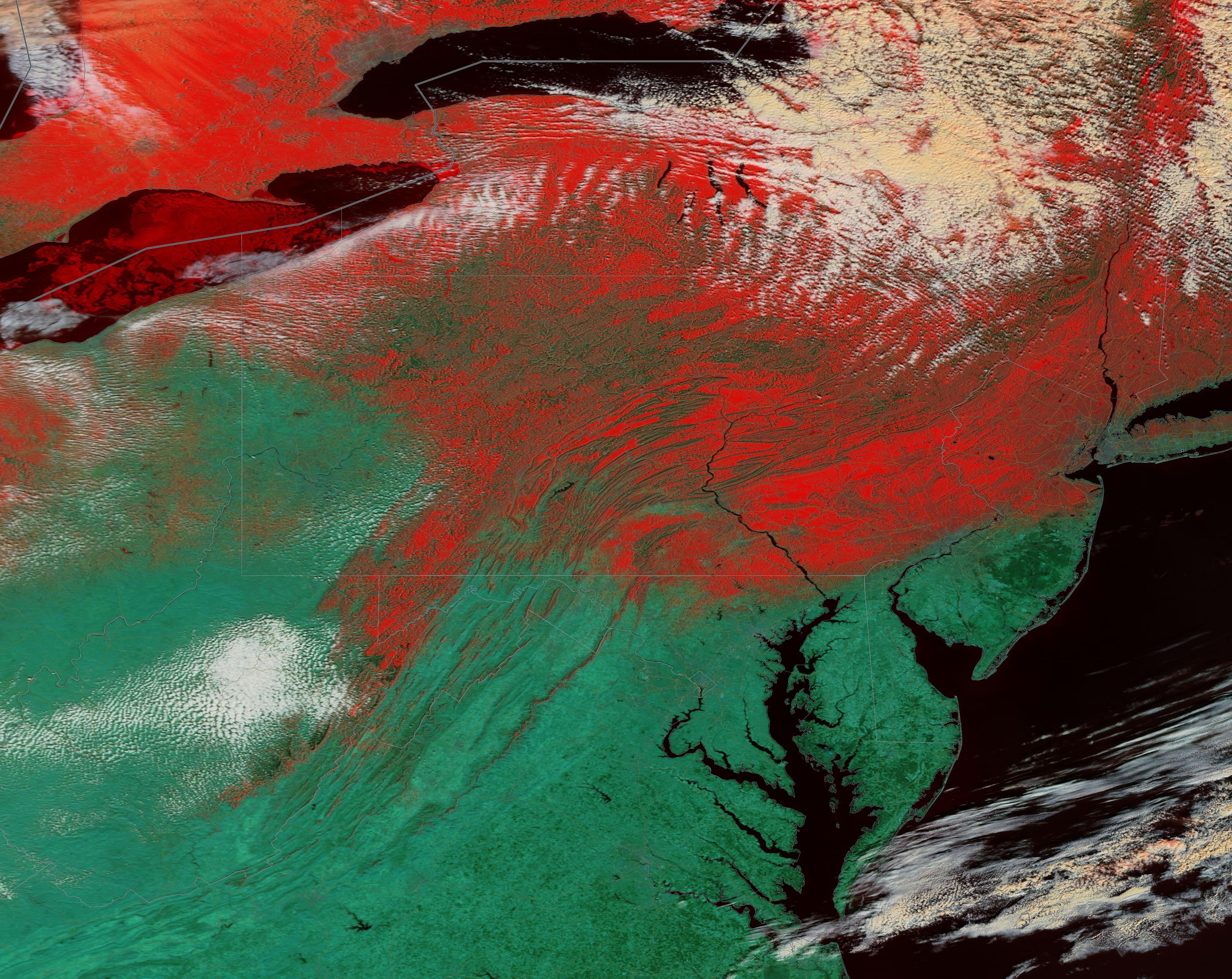
English: Several snowstorms swept across the United States in February 2021, leaving a lingering layer of snow atop parts of the Appalachian Mountains, the Mid-Atlantic, and the Northeast. The Moderate Resolution Imaging Spectroradiometer (MODIS) on board NASA’s Terra satellite acquired a stunning false-color image that highlighted snow and ice on February 25.
Even though a satellite image looks similar to a snapshot taken from a phone or camera, it’s not actually the same thing. Satellite instruments collect various data through “bands”, with each band collecting different data. To make an image, scientists will combine data from three bands, assigning each a color: red, blue, or green. Because each band collects different data, the resulting image will highlight (make visible) different aspects of what is happening on Earth. A true-color image (bands 1,4,3) appears very much like what we see with our own eyes, because these bands actually measure red, green, and blue (visible) light. A false-color image uses data from at least one non-visible wavelength, but the bands are still represented in red, green, or blue. As a result, the final image appears shows the Earth differently from how our eyes would see, revealing unique aspects of the land, water, or atmosphere that cannot be seen with our own eyes. This image uses the combination of Bands 3,6,7 to reveal snow and ice. These are highly reflective in visible light (Band 3) and very absorbent in short-wave infrared (Bands 6 and 7). When assigned the colors of red, green, and blue and combined into an image, snow and ice appear bright red—and the thicker the ice or snow, the brighter the red shows up. Small amounts of ice crystals, such as in high-level clouds, will show up in faint reddish-orange or peach tones. Vegetation reflects in Band 6, so will appear green. Bare soil will appear bright cyan (greenish blue) while liquid (lakes, streams and oceans) appears very dark and cloud show up as white. Using this color combination, it is easy to see that snow sits atop the ridges of the Appalachians from West Virginia northward and blankets the ground from northern Maryland to the states of Vermont and New Hampshire and across southern Quebec, Canada. It would be difficult to discern cloud from snow in a true-color image, but here it is simple to tell them apart. If you want to learn more about how false-color satellite imagery is created and utilized, you will want to check out an article published by NASA’s Earth Observatory. The article, titled “Why is that Forest Red and that Cloud Blue? How to Interpret a False-Color Satellite Image” is available here. |
||
| Date | Taken on 25 February 2021 | ||
| Source |
Snow in Northeastern United States (direct link)
|
||
| Author | MODIS Land Rapid Response Team, NASA GSFC |
| This media is a product of the Terra mission Credit and attribution belongs to the mission team, if not already specified in the "author" row |
Licensing[edit]
.jpg&action=edit§ion=2)
| This file is in the public domain in the United States because it was solely created by NASA. NASA copyright policy states that "NASA material is not protected by copyright unless noted". (See Template:PD-USGov, NASA copyright policy page or JPL Image Use Policy.) | ||
 |
Warnings:
|
File history
Click on a date/time to view the file as it appeared at that time.
| Date/Time | Thumbnail | Dimensions | User | Comment | |
|---|---|---|---|---|---|
| current | 17:59, 30 January 2024 | | 4,261 × 3,387 (2.2 MB) | OptimusPrimeBot (talk | contribs) | #Spacemedia - Upload of http://modis.gsfc.nasa.gov/gallery/images/image03012021_250m.jpg via Commons:Spacemedia |
You cannot overwrite this file.
File usage on Commons
There are no pages that use this file.
.jpg&oldid=847271750)