File:Snow-Covered Taklimakan Desert.jpg
Jump to navigation
Jump to search

Size of this preview: 780 × 600 pixels. Other resolutions: 312 × 240 pixels | 624 × 480 pixels | 999 × 768 pixels | 1,280 × 985 pixels | 2,560 × 1,969 pixels | 5,200 × 4,000 pixels.
Original file (5,200 × 4,000 pixels, file size: 2.69 MB, MIME type: image/jpeg)
Captions
Captions
Add a one-line explanation of what this file represents
Summary[edit]
| Description |
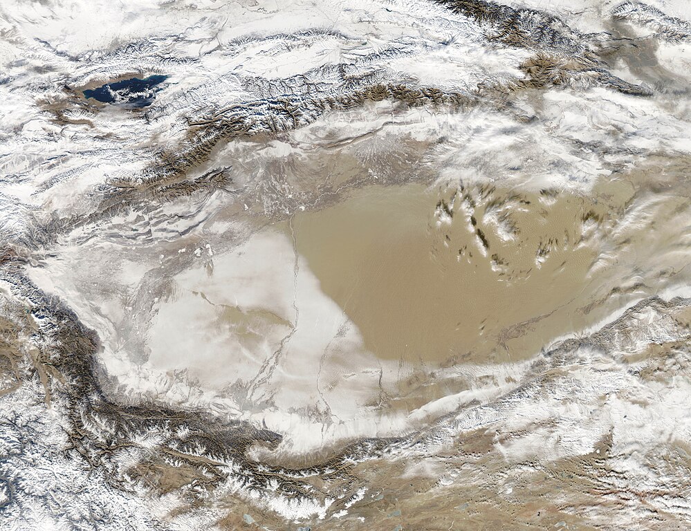
English: Snow-covered deserts are rare, but that’s exactly what the Moderate Resolution Imaging Spectroradiometer (MODIS) on NASA’s Aqua satellite observed as it passed over the Taklimakan Desert in western China on Jan. 2, 2013. Snow has covered much of the desert since a storm blew through the area on Dec. 26. The day after the storm, Chinese Central Television (CNTV) reported that the Xinjian Uygyr autonomous region was one of the areas hardest hit.
The Taklimakan is one of the world’s largest—and hottest—sandy deserts. Water flowing into the Tarim Basin has no outlet, so over the years, sediments have steadily accumulated. In parts of the desert, sand can pile up to 300 meters (roughly 1,000 feet) high. The mountains that enclose the sea of sand—the Tien Shan in the north and the Kunlun Shan in the south—were also covered with what appeared to be a significantly thicker layer of snow in January 2013. |
| Date | |
| Source | http://www.nasa.gov/multimedia/imagegallery/image_feature_2421.html |
| Author | NASA/Aqua |
Licensing[edit]
| This file is in the public domain in the United States because it was solely created by NASA. NASA copyright policy states that "NASA material is not protected by copyright unless noted". (See Template:PD-USGov, NASA copyright policy page or JPL Image Use Policy.) | ||
 |
Warnings:
|
File history
Click on a date/time to view the file as it appeared at that time.
| Date/Time | Thumbnail | Dimensions | User | Comment | |
|---|---|---|---|---|---|
| current | 05:45, 17 January 2013 | | 5,200 × 4,000 (2.69 MB) | Salamander724 (talk | contribs) | {{Information |Description ={{en|1=Snow-covered deserts are rare, but that’s exactly what the Moderate Resolution Imaging Spectroradiometer (MODIS) on NASA’s Aqua satellite observed as it passed over the Taklimakan Desert in western China on Jan... |
You cannot overwrite this file.
File usage on Commons
The following page uses this file:
- File:Snow-Covered Desert.jpg (file redirect)
File usage on other wikis
The following other wikis use this file:
- Usage on en.wikipedia.org
- Usage on te.wikipedia.org