File:Situation in the Donbas Region (August 22 2014).png
Jump to navigation
Jump to search

Size of this preview: 478 × 599 pixels. Other resolutions: 191 × 240 pixels | 383 × 480 pixels | 613 × 768 pixels | 817 × 1,024 pixels | 1,634 × 2,048 pixels | 5,985 × 7,500 pixels.
Original file (5,985 × 7,500 pixels, file size: 56.46 MB, MIME type: image/png)
Captions
Captions
Add a one-line explanation of what this file represents
Summary[edit]
.png&action=edit§ion=1)
| Description |
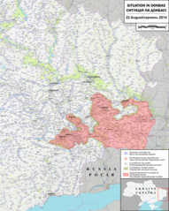
English: Map of the situation in Donbas, August 22 2014, prior to Russian forces opening a new front at Novoazovsk and sub-sequentially encircling Ilovaisk. Made using OpenTopoMap data. Source SVG file was too large for Wikimedia so I uploaded the PNG version. |
| Date | |
| Source | Own work |
| Author | Rr016 |
| Permission (Reusing this file) |
This vector image includes elements that have been taken or adapted from this file: |
Licensing[edit]
.png&action=edit§ion=2)
I, the copyright holder of this work, hereby publish it under the following license:
This file is licensed under the Creative Commons Attribution-Share Alike 4.0 International license.
- You are free:
- to share – to copy, distribute and transmit the work
- to remix – to adapt the work
- Under the following conditions:
- attribution – You must give appropriate credit, provide a link to the license, and indicate if changes were made. You may do so in any reasonable manner, but not in any way that suggests the licensor endorses you or your use.
- share alike – If you remix, transform, or build upon the material, you must distribute your contributions under the same or compatible license as the original.
File history
Click on a date/time to view the file as it appeared at that time.
| Date/Time | Thumbnail | Dimensions | User | Comment | |
|---|---|---|---|---|---|
| current | 18:58, 28 August 2022 | | 5,985 × 7,500 (56.46 MB) | Rr016 (talk | contribs) | Uploaded own work with UploadWizard |
You cannot overwrite this file.
File usage on Commons
The following 2 pages use this file:
.png&oldid=685831780)