File:Site of Fencehouses station (geograph 2584826).jpg
Site_of_Fencehouses_station_(geograph_2584826).jpg (640 × 480 pixels, file size: 72 KB, MIME type: image/jpeg)
Captions
Captions
Summary[edit]
.jpg&action=edit§ion=1)
| Description |
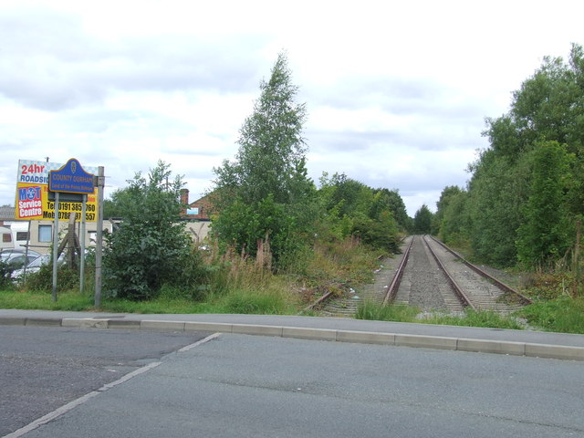
English: Site of Fencehouses station This was once the site of Fencehouses railway station. The railway through Fencehouses lost its regular passenger trains in the 1960s. The line remained in use, both for freight trains and occasionally for diverted passenger trains on days when the main line through Durham and Chester-le-Street was closed for engineering work. The line became disused in around 1992. Although no maintenance work is carried out, this railway line is still owned by Network Rail, and is being retained in case there is a need to bring it back into use in future. It would clearly need considerable work to restore the line to a useable state. At this location, the tracks are interrupted as tarmac has been laid across the site of a level crossing. The sign to the left of the image shows that the railway formed the boundary between Tyne & Wear and County Durham. |
| Date | |
| Source | From geograph.org.uk |
| Author | Malc McDonald |
| Permission (Reusing this file) |
Creative Commons Attribution Share-alike license 2.0 |
| Attribution (required by the license) | Malc McDonald / Site of Fencehouses station / |
| Camera location | | View this and other nearby images on: OpenStreetMap |
|---|
.jpg¶ms=054.846055_N_-001.506158_E_globe:Earth_type:camera_source:geograph-osgb36(NZ31815025)_heading:0.00&language=en)
| Object location | | View this and other nearby images on: OpenStreetMap |
|---|
.jpg¶ms=054.846230_N_-001.506310_E_globe:Earth_class:object_type:object_source:geograph-osgb36(NZ31805027)_heading:0.00&language=en)
Licensing[edit]
.jpg&action=edit§ion=2)

|
This image was taken from the Geograph project collection. See this photograph's page on the Geograph website for the photographer's contact details. The copyright on this image is owned by Malc McDonald and is licensed for reuse under the Creative Commons Attribution-ShareAlike 2.0 license.
|
- You are free:
- to share – to copy, distribute and transmit the work
- to remix – to adapt the work
- Under the following conditions:
- attribution – You must give appropriate credit, provide a link to the license, and indicate if changes were made. You may do so in any reasonable manner, but not in any way that suggests the licensor endorses you or your use.
- share alike – If you remix, transform, or build upon the material, you must distribute your contributions under the same or compatible license as the original.
File history
Click on a date/time to view the file as it appeared at that time.
| Date/Time | Thumbnail | Dimensions | User | Comment | |
|---|---|---|---|---|---|
| current | 18:04, 2 November 2020 | | 640 × 480 (72 KB) | Lamberhurst (talk | contribs) | Transferred from geograph.co.uk using [https://tools.wmflabs.org/geograph2commons/ geograph2commons] |
You cannot overwrite this file.
File usage on Commons
The following page uses this file:
File usage on other wikis
The following other wikis use this file:
- Usage on en.wikipedia.org
.jpg&oldid=549330023)