File:Sinal avançado ferroviário em Portugal (vermelho e amarelo).jpg
Original file (1,133 × 1,830 pixels, file size: 266 KB, MIME type: image/jpeg)
Captions
Captions
Summary[edit]
.jpg&action=edit§ion=1)
| Description |
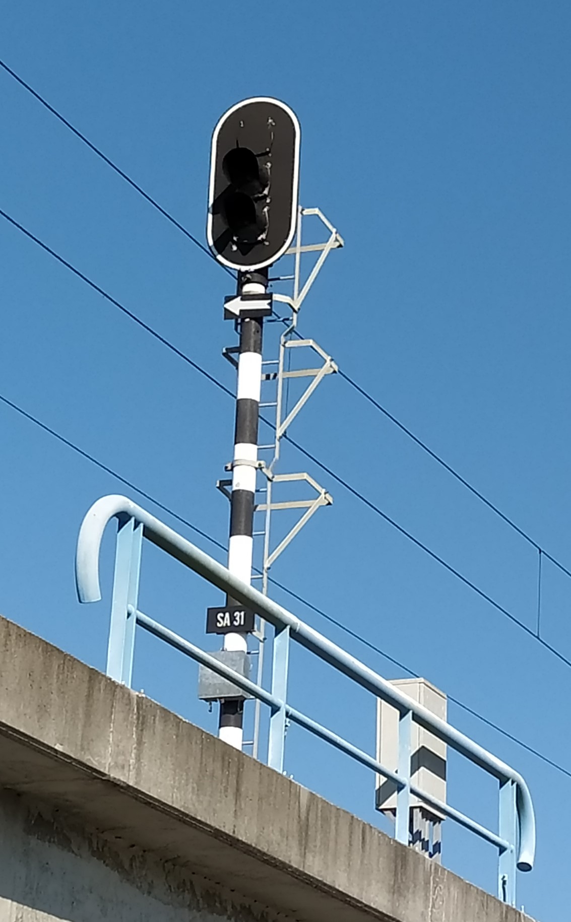
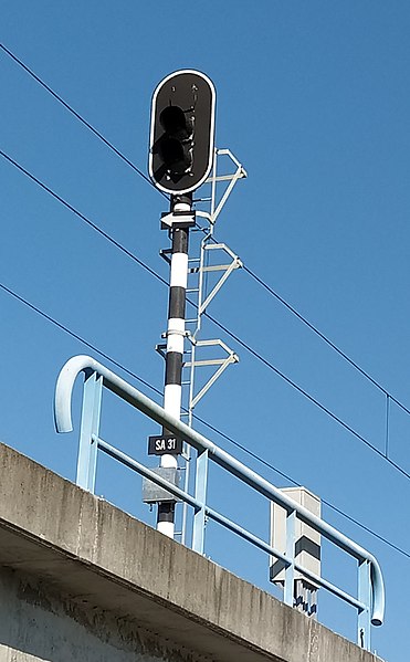
Português: Um sinal avançado ferroviário numa ponte de betão em Portugal, que passa sobre a ria de Aveiro e faz parte do ramal ferroviário do porto da mesma localidade.
O sinal tem dois focos luminosos, apagados: vermelho a meio e amarelo em baixo. Apesar de haver espaço acima para instalar um terceiro foco de cor verde, este nunca viria a ser utilizado no contexto em que o sinal se encontra, pelo que foi omitido. Debaixo dos focos, há uma seta a apontar para a esquerda. Isto indica que o sinal está instalado à direita da via férrea, contrário ao habitual, que seria à esquerda. Mais abaixo, há uma placa com a identificação deste sinal: "SA 31", abreviação de "Sinal Avançado n.º 31". Os postes destes sinais são sempre pintados às listas brancas e pretas com 30 cm de altura.English: A distant signal on a concrete bridge in Portugal, crossing over the Aveiro Lagoon. It is a part of the branch rail line going to the port of Aveiro.
This signal has two lights, turned off in the picture: red on top and yellow on the bottom. There is a slot on top to accomodate a green light; however, because there is no use for such a light in this context, it has been omitted. Under the lights, there's an arrow pointing left, indicating that this signal is installed on the right side of the track. This is contrary to the usual practice in Portugal of installing signals to the left of tracks. Further below, there's a plaque identifying this signal: "SA 31", short for "distant signal #31". The poles of every distant signal is painted with black-and-white stripes with a height of 30 cm each. |
| Date | |
| Source | Own work |
| Author | HedgiePT |
| Camera location | | View this and other nearby images on: OpenStreetMap |
|---|
.jpg¶ms=040.654589_N_-008.638040_E_globe:Earth_type:camera__&language=en)
Licensing[edit]
.jpg&action=edit§ion=2)
- You are free:
- to share – to copy, distribute and transmit the work
- to remix – to adapt the work
- Under the following conditions:
- attribution – You must give appropriate credit, provide a link to the license, and indicate if changes were made. You may do so in any reasonable manner, but not in any way that suggests the licensor endorses you or your use.
- share alike – If you remix, transform, or build upon the material, you must distribute your contributions under the same or compatible license as the original.
File history
Click on a date/time to view the file as it appeared at that time.
| Date/Time | Thumbnail | Dimensions | User | Comment | |
|---|---|---|---|---|---|
| current | 00:10, 31 October 2020 | | 1,133 × 1,830 (266 KB) | HedgiePT (talk | contribs) | Uploaded own work with UploadWizard |
You cannot overwrite this file.
File usage on Commons
The following 3 pages use this file:
.jpg&oldid=732923057)