File:Sidings at Craven Arms (geograph 6506393).jpg
Jump to navigation
Jump to search

Size of this preview: 800 × 525 pixels. Other resolutions: 320 × 210 pixels | 640 × 420 pixels | 1,024 × 672 pixels | 1,280 × 841 pixels | 2,560 × 1,681 pixels | 3,192 × 2,096 pixels.
Original file (3,192 × 2,096 pixels, file size: 2.69 MB, MIME type: image/jpeg)
Captions
Captions
Add a one-line explanation of what this file represents
Summary
[edit].jpg&action=edit§ion=1)
| Description |
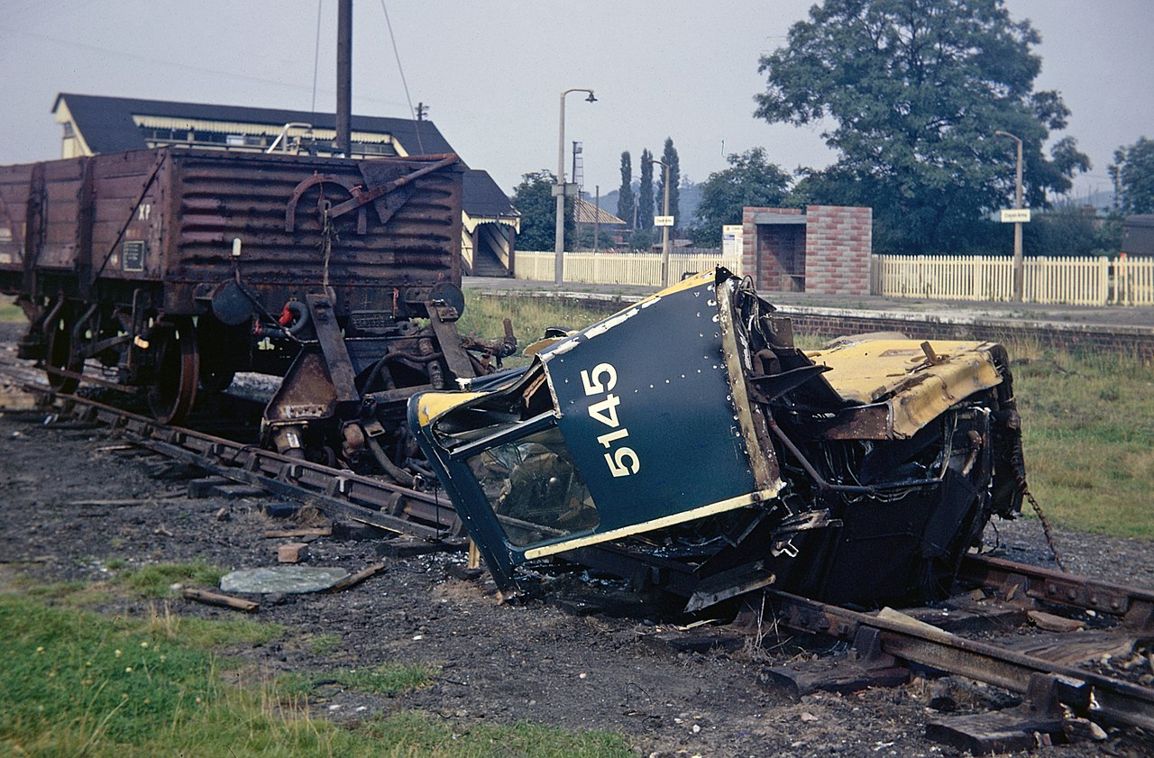
English: Sidings at Craven Arms In 1973 the goods yard at Craven Arms station was more or less defunct but it did contain this intriguing item. D5145, later designated class 24, was built at Derby in 1960 and led a fairly uneventful life until it was involved in a fatal collision at Kidsgrove in April 1973. The no 2 end cab was crushed to the bulkhead and was subsequently replaced at Derby Works. Why the battered remains of the original cab ended up here at Craven Arms is a mystery. |
| Date | |
| Source | From geograph.org.uk |
| Author | Stephen McKay |
| Permission (Reusing this file) |
Creative Commons Attribution Share-alike license 2.0 |
| Attribution (required by the license) | Stephen McKay / Sidings at Craven Arms / |
| Camera location | | View this and other nearby images on: OpenStreetMap |
|---|
.jpg¶ms=052.441994_N_-002.837926_E_globe:Earth_type:camera_source:geograph-osgb36(SO43148300)_heading:22.00&language=en)
| Object location | | View this and other nearby images on: OpenStreetMap |
|---|
.jpg¶ms=052.442000_N_-002.837780_E_globe:Earth_class:object_type:object_source:geograph-osgb36(SO43158300)_heading:22.00&language=en)
Licensing
[edit].jpg&action=edit§ion=2)

|
This image was taken from the Geograph project collection. See this photograph's page on the Geograph website for the photographer's contact details. The copyright on this image is owned by Stephen McKay and is licensed for reuse under the Creative Commons Attribution-ShareAlike 2.0 license.
|
This file is licensed under the Creative Commons Attribution-Share Alike 2.0 Generic license.
Attribution: Stephen McKay
- You are free:
- to share – to copy, distribute and transmit the work
- to remix – to adapt the work
- Under the following conditions:
- attribution – You must give appropriate credit, provide a link to the license, and indicate if changes were made. You may do so in any reasonable manner, but not in any way that suggests the licensor endorses you or your use.
- share alike – If you remix, transform, or build upon the material, you must distribute your contributions under the same or compatible license as the original.
File history
Click on a date/time to view the file as it appeared at that time.
| Date/Time | Thumbnail | Dimensions | User | Comment | |
|---|---|---|---|---|---|
| current | 12:27, 11 April 2021 | | 3,192 × 2,096 (2.69 MB) | Lamberhurst (talk | contribs) | Transferred from geograph.co.uk using [https://tools.wmflabs.org/geograph2commons/ geograph2commons] |
You cannot overwrite this file.
File usage on Commons
The following 3 pages use this file:
.jpg&oldid=648002112)