File:Shilluk land area in South Sudan.svg
Jump to navigation
Jump to search

Size of this PNG preview of this SVG file: 282 × 363 pixels. Other resolutions: 186 × 240 pixels | 373 × 480 pixels | 597 × 768 pixels | 795 × 1,024 pixels | 1,591 × 2,048 pixels.
Original file (SVG file, nominally 282 × 363 pixels, file size: 224 KB)
Captions
Captions
Add a one-line explanation of what this file represents
Summary[edit]
| Description |
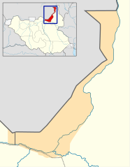
Français : Zone de répartition du peuple Shilluk au Sud-Soudan. English: Shilluk land area in South-Sudan. |
| Date | (UTC) |
| Source |
This file was derived from: South Sudan location map.svg: |
| Author |
|
| This is a retouched picture, which means that it has been digitally altered from its original version. Modifications: Added Shilluk land. The original can be viewed here: South Sudan location map.svg:
|
Licensing[edit]
I, the copyright holder of this work, hereby publish it under the following license:
This file is licensed under the Creative Commons Attribution-Share Alike 3.0 Unported license.
- You are free:
- to share – to copy, distribute and transmit the work
- to remix – to adapt the work
- Under the following conditions:
- attribution – You must give appropriate credit, provide a link to the license, and indicate if changes were made. You may do so in any reasonable manner, but not in any way that suggests the licensor endorses you or your use.
- share alike – If you remix, transform, or build upon the material, you must distribute your contributions under the same or compatible license as the original.
Original upload log[edit]
This image is a derivative work of the following images:
- File:South_Sudan_location_map.svg licensed with Cc-by-sa-3.0
- 2011-08-18T08:21:54Z Spesh531 1561x1133 (210177 Bytes) I am reverting and fixing all of the templates ot the best of my ability, I can need some help
- 2011-08-18T07:53:03Z NordNordWest 1500x1133 (175465 Bytes) you cannot change the area that is shown without adjusting all templates in which this map is used
- 2011-08-17T23:20:48Z Spesh531 1561x1133 (210177 Bytes) adding a disputed territory
- 2011-07-18T11:42:32Z NordNordWest 1500x1133 (175465 Bytes) corr
- 2011-07-08T12:04:42Z NordNordWest 1500x1133 (176591 Bytes) upd
- 2011-02-18T14:23:36Z NordNordWest 1500x1133 (182416 Bytes) =={{int:filedesc}}== {{Information |Description= {{de|Positionskarte vom [[:de:Südsudan|Südsudan]]}} Quadratische Plattkarte, N-S-Streckung 101 %. Geographische Begrenzung der Karte: * N: 12.7° N * S: 3.2° N * W: 23.7° O
Uploaded with derivativeFX
File history
Click on a date/time to view the file as it appeared at that time.
| Date/Time | Thumbnail | Dimensions | User | Comment | |
|---|---|---|---|---|---|
| current | 16:58, 8 January 2013 | | 282 × 363 (224 KB) | Flappiefh (talk | contribs) | == {{int:filedesc}} == {{Information |Description={{fr|Zone de répartition du peuple Shilluk au Sud-Soudan.}}{{en|Shilluk land area in South-Sudan.}} |Source={{Derived from|South_Sudan_location_map.svg|display=50}} |Date=2013-01-08 16:56 (UTC) |Author... |
You cannot overwrite this file.
File usage on Commons
There are no pages that use this file.
File usage on other wikis
The following other wikis use this file:
- Usage on en.wikipedia.org
- Usage on fr.wikipedia.org