File:Sharp Mountain NE peaks, USGS Mahanoy Pennsylvania Quadrant SE=maha92se.jpg
Jump to navigation
Jump to search

Size of this preview: 800 × 496 pixels. Other resolutions: 320 × 198 pixels | 640 × 397 pixels | 1,024 × 635 pixels | 1,262 × 782 pixels.
Original file (1,262 × 782 pixels, file size: 261 KB, MIME type: image/jpeg)
Captions
Captions
Add a one-line explanation of what this file represents
Summary[edit]
| Description |
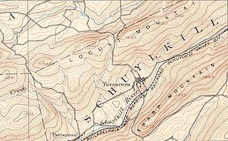
English: Cut down excerpt of 15 minute series USGS Hazelton Quadrant Map This map show the region just east of Tamaqua, Pennsylvania where the East Tip of Sharp Mountain ends in Tamaqua Gap.
related/continuation: File:Tamaqua, Pennsylvania Topography USGS Hazleton Quadrant Map of 1893= hzlt93sw.jpg |
| Date | |
| Source | PD-USGS |
| Author | USGS |
Licensing[edit]
This work is in the public domain in the United States because it is a work prepared by an officer or employee of the United States Government as part of that person’s official duties under the terms of Title 17, Chapter 1, Section 105 of the US Code.
Note: This only applies to original works of the Federal Government and not to the work of any individual U.S. state, territory, commonwealth, county, municipality, or any other subdivision. This template also does not apply to postage stamp designs published by the United States Postal Service since 1978. (See § 313.6(C)(1) of Compendium of U.S. Copyright Office Practices). It also does not apply to certain US coins; see The US Mint Terms of Use.
|
 | |
| This file has been identified as being free of known restrictions under copyright law, including all related and neighboring rights. | ||
File history
Click on a date/time to view the file as it appeared at that time.
| Date/Time | Thumbnail | Dimensions | User | Comment | |
|---|---|---|---|---|---|
| current | 03:56, 24 September 2013 | | 1,262 × 782 (261 KB) | Fabartus (talk | contribs) | User created page with UploadWizard |
You cannot overwrite this file.
File usage on Commons
There are no pages that use this file.