File:Shakemap, 2008 Kyrgyzstan earthquake.jpg
Jump to navigation
Jump to search

Size of this preview: 510 × 600 pixels. Other resolutions: 204 × 240 pixels | 612 × 720 pixels.
Original file (612 × 720 pixels, file size: 143 KB, MIME type: image/jpeg)
Captions
Captions
Add a one-line explanation of what this file represents
| Description |
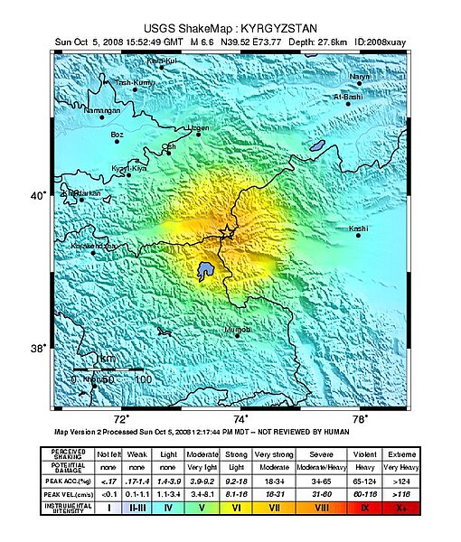
English: USGS ShakeMap of the 2008 Kyrgyzstan earthquake. |
|||
| Date | ||||
| Source | https://earthquake.usgs.gov/eqcenter/shakemap/global/shake/2008xuay | |||
| Author | United States Geological Survey | |||
| Permission (Reusing this file) |
|
File history
Click on a date/time to view the file as it appeared at that time.
| Date/Time | Thumbnail | Dimensions | User | Comment | |
|---|---|---|---|---|---|
| current | 20:49, 10 October 2008 | | 612 × 720 (143 KB) | AstroImager001 (talk | contribs) | {{Information |Description={{en|1=USGS ShakeMap of the 2008 Kyrgyzstan earthquake.}} |Source=http://earthquake.usgs.gov/eqcenter/shakemap/global/shake/2008xuay |Author=United States Geological Survey |Date=2008-10-05 |Permission={{PD-USGov-USGS}} |other_v |
You cannot overwrite this file.
File usage on Commons
The following page uses this file:
- File:Kyrgzstan earthquake shakemap.jpg (file redirect)
File usage on other wikis
The following other wikis use this file:
- Usage on ca.wikipedia.org
- Usage on en.wikipedia.org
- Usage on es.wikipedia.org
- Usage on fr.wikipedia.org
- Usage on ja.wikipedia.org
- Usage on nl.wikipedia.org
- Usage on pl.wikipedia.org
- Usage on ru.wikipedia.org
- Usage on tr.wikipedia.org
- Usage on www.wikidata.org