File:Senex - France postal and road map 1719.jpeg
Jump to navigation
Jump to search
Size of this preview: 677 × 599 pixels. Other resolutions: 271 × 240 pixels | 542 × 480 pixels | 868 × 768 pixels | 1,157 × 1,024 pixels | 2,313 × 2,048 pixels | 4,698 × 4,159 pixels.
Original file (4,698 × 4,159 pixels, file size: 20.97 MB, MIME type: image/jpeg)
Captions
Captions
Add a one-line explanation of what this file represents
Summary[edit]
| Description |
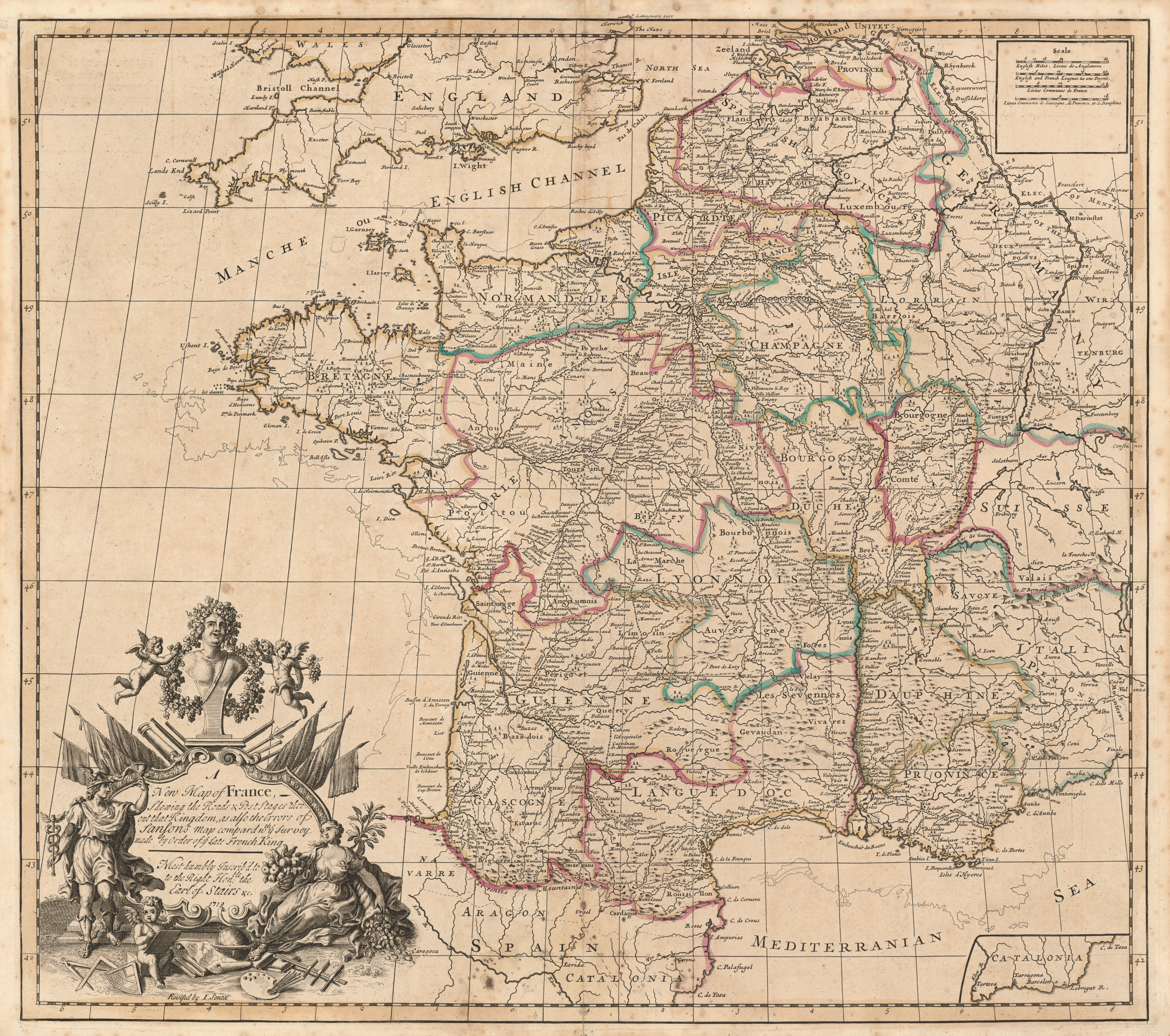
English: John Senex, 1678–1740. “A New Map of France: Shewing the Roads & Post Stages Thro-out That Kingdom, as Also the Errors of Sanson’s Map Compard with ye Survey Made by Order of ye Late French King” ([London: J. Senex], 1719). Copperplate map, with added color, 50 × 56 cm. [Historic Maps Collection].
English cartographer Senex compares his postal map to Sanson’s [see previous entry], over which he has superimposed a “corrected” version. The outline of Sanson’s map can be seen along the Atlantic and Mediterranean coasts. “[Y]e Survey Made by Order of ye Late French King” was a plan, approved by King Louis XIV (1638–1715) in 1679, for a much more accurate map of France based on the latest scientific techniques. This was begun by Jean Picard (1620–1682) and continued by Giovanni Dominico Cassini (1625–1712); preliminary work, based on triangulation, revised the outlines of the country and appeared in the 1693 map “Carte de France corrigée par ordre du roy sur les observations de Mss. de l’Academie des Sciences.” That is the source that Senex used for this “new” postal map. The postal routes have greatly expanded in the interim years. |
||||||||||||||||
| Date | |||||||||||||||||
| Source | http://libweb5.princeton.edu/visual_materials/maps/websites/thematic-maps/qualitative/senex-map-1719.jpg linked from this webpage | ||||||||||||||||
| Author |
|
||||||||||||||||
Licensing[edit]
|
This is a faithful photographic reproduction of a two-dimensional, public domain work of art. The work of art itself is in the public domain for the following reason:
The official position taken by the Wikimedia Foundation is that "faithful reproductions of two-dimensional public domain works of art are public domain".
This photographic reproduction is therefore also considered to be in the public domain in the United States. In other jurisdictions, re-use of this content may be restricted; see Reuse of PD-Art photographs for details. | ||||
File history
Click on a date/time to view the file as it appeared at that time.
| Date/Time | Thumbnail | Dimensions | User | Comment | |
|---|---|---|---|---|---|
| current | 22:37, 8 April 2018 | | 4,698 × 4,159 (20.97 MB) | Ww2censor (talk | contribs) | == {{int:filedesc}} == {{Information |Description={{en| John Senex, 1678–1740. “A New Map of France: Shewing the Roads & Post Stages Thro-out That Kingdom, as Also the Errors of Sanson’s Map Compard with ye Survey Made by Order of ye Late French King” ([London: J. Senex], 1719). Copperplate map, with added color, 50 × 56 cm. [Historic Maps Collection]. English cartographer Senex compares his postal map to Sanson’s [see previous entry], over which he has superimposed a “corrected” version. Th... |
You cannot overwrite this file.
File usage on Commons
The following 2 pages use this file: