File:Semresrr.jpg
Jump to navigation
Jump to search
Size of this preview: 422 × 599 pixels. Other resolutions: 169 × 240 pixels | 545 × 774 pixels.
Original file (545 × 774 pixels, file size: 122 KB, MIME type: image/jpeg)
Captions
Captions
Add a one-line explanation of what this file represents
Summary[edit]
| Description |
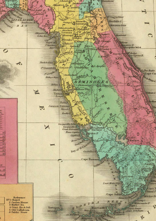
English: Reservation land of the Seminoles in the 1820s and 1830s. Published in 1831 by A. Finley Philadelphia in A New General Atlas Comprising a Complete Set of Maps, representing the Grand Divisions Of The Globe. David Rumsey Map Collection.
Downloaded from http://www.johnhorse.com/trail/01/c/08.htm Originally published in 1831:
|
| Source | see above |
| Author | Anthony Finley |
Licensing[edit]
This media file is in the public domain in the United States. This applies to U.S. works where the copyright has expired, often because its first publication occurred prior to January 1, 1929, and if not then due to lack of notice or renewal. See this page for further explanation.
|
 | |
 |
This image might not be in the public domain outside of the United States; this especially applies in the countries and areas that do not apply the rule of the shorter term for US works, such as Canada, Mainland China (not Hong Kong or Macao), Germany, Mexico, and Switzerland. The creator and year of publication are essential information and must be provided. See Wikipedia:Public domain and Wikipedia:Copyrights for more details.
|
Original upload log[edit]
The original description page was here. All following user names refer to en.wikipedia.
- 2006-10-21 18:04 Dalbury 229×325×8 (20506 bytes) Downloaded from http://www.johnhorse.com/trail/01/c/08.htm Published in 1831 by A. Finley Philadelphia in ''A New General Atlas Comprising a Complete Set of Maps, representing the Grand Divisions Of The Globe''.
File history
Click on a date/time to view the file as it appeared at that time.
| Date/Time | Thumbnail | Dimensions | User | Comment | |
|---|---|---|---|---|---|
| current | 11:59, 2 March 2008 | | 545 × 774 (122 KB) | SalomonCeb (talk | contribs) | Better version in http://www.johnhorse.com/trail/01/c/08zz.htm |
| 11:56, 2 March 2008 |  | 229 × 325 (20 KB) | SalomonCeb (talk | contribs) | {{Information |Description={{en|Reservation land of the Seminoles in the 1820s and 1830s. Published in 1831 by A. Finley Philadelphia in A New General Atlas Comprising a Complete Set of Maps, representing the Grand Divisions Of The Globe. David Rumsey Ma |
You cannot overwrite this file.
File usage on Commons
There are no pages that use this file.
File usage on other wikis
The following other wikis use this file:
- Usage on fr.wikipedia.org
- Usage on hu.wikipedia.org
- Usage on it.wikipedia.org