File:Second world war europe 1943-1945 map de.png
Jump to navigation
Jump to search

Size of this preview: 654 × 600 pixels. Other resolutions: 262 × 240 pixels | 523 × 480 pixels | 837 × 768 pixels | 1,088 × 998 pixels.
Original file (1,088 × 998 pixels, file size: 274 KB, MIME type: image/png)
Captions
Captions
Add a one-line explanation of what this file represents
Summary[edit]
| Description |
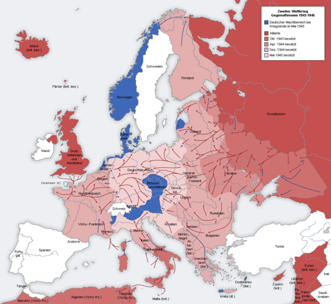
Deutsch: Zweiter Weltkrieg Europa 1943-1945 English: Second world war europe 1943-1945 in German |
| Date | |
| Source |
Deutsch: Eigene Karte, basierend auf den Karten der University of Texas Libraries English: Own map, based on the maps of the University of Texas Libraries |
| Author | San Jose |
| Other versions |
Derivative works of this file: |
Licensing[edit]

|
Permission is granted to copy, distribute and/or modify this document under the terms of the GNU Free Documentation License, Version 1.2 or any later version published by the Free Software Foundation; with no Invariant Sections, no Front-Cover Texts, and no Back-Cover Texts. A copy of the license is included in the section entitled GNU Free Documentation License. |
| This file is licensed under the Creative Commons Attribution-Share Alike 3.0 Unported license. | ||
| ||
| This licensing tag was added to this file as part of the GFDL licensing update. |
File history
Click on a date/time to view the file as it appeared at that time.
| Date/Time | Thumbnail | Dimensions | User | Comment | |
|---|---|---|---|---|---|
| current | 22:57, 24 October 2021 | | 1,088 × 998 (274 KB) | Rebelbear (talk | contribs) | Kanalinseln (dt.) |
| 19:07, 20 October 2012 |  | 1,088 × 998 (177 KB) | Ras67 (talk | contribs) | cropped and optimized | |
| 13:07, 26 May 2012 |  | 1,090 × 1,000 (233 KB) | Hanhil (talk | contribs) | Walcheren und Zuid-Beveland in den Niederlanden wurden 1944 von den allierten Truppen erobert. | |
| 13:32, 22 August 2005 |  | 1,090 × 1,000 (195 KB) | Rony (talk | contribs) |
You cannot overwrite this file.
File usage on Commons
The following 5 pages use this file:
File usage on other wikis
The following other wikis use this file:
- Usage on bg.wikipedia.org
- Usage on cs.wikipedia.org
- Usage on cs.wikibooks.org
- Usage on da.wikipedia.org
- Usage on de.wikipedia.org
- Benutzer:San Jose
- Deutsche Westfront 1944/1945
- Benutzer:David Wintzer/Karten
- Geschichte des Mittelmeerraumes
- Georg Lindemann
- Luftangriffe auf Dresden
- Disarmed Enemy Forces
- Fester Platz (Wehrmacht)
- Diskussion:Fester Platz (Wehrmacht)
- Diskussion:Oskar Schindler/Archiv
- Dritte Tschechoslowakische Republik
- Usage on es.wikipedia.org
- Usage on fr.wikipedia.org
- Usage on fy.wikipedia.org
- Usage on hu.wikipedia.org
- Usage on it.wikipedia.org
- Usage on ja.wikipedia.org
- Usage on ko.wikipedia.org
- Usage on ksh.wikipedia.org
- Usage on nds.wikipedia.org
- Usage on nl.wikipedia.org
- Usage on no.wikipedia.org
- Usage on rm.wikipedia.org
- Usage on ru.wikipedia.org
- Usage on sr.wikipedia.org
- Usage on stq.wikipedia.org
- Usage on zh.wikipedia.org